


<< Text Pages >> Kerkenes - Ancient Village or Settlement in Turkey
Submitted by AlexHunger on Friday, 04 August 2006 Page Views: 3560
Multi-periodSite Name: Kerkenes Alternative Name: Kerkenes DağıCountry: Turkey
NOTE: This site is 0.983 km away from the location you searched for.
Type: Ancient Village or Settlement
Nearest Town: Sorgun Nearest Village: Şahmuratlı
Latitude: 39.750000N Longitude: 35.060000E
Condition:
| 5 | Perfect |
| 4 | Almost Perfect |
| 3 | Reasonable but with some damage |
| 2 | Ruined but still recognisable as an ancient site |
| 1 | Pretty much destroyed, possibly visible as crop marks |
| 0 | No data. |
| -1 | Completely destroyed |
| 5 | Superb |
| 4 | Good |
| 3 | Ordinary |
| 2 | Not Good |
| 1 | Awful |
| 0 | No data. |
| 5 | Can be driven to, probably with disabled access |
| 4 | Short walk on a footpath |
| 3 | Requiring a bit more of a walk |
| 2 | A long walk |
| 1 | In the middle of nowhere, a nightmare to find |
| 0 | No data. |
| 5 | co-ordinates taken by GPS or official recorded co-ordinates |
| 4 | co-ordinates scaled from a detailed map |
| 3 | co-ordinates scaled from a bad map |
| 2 | co-ordinates of the nearest village |
| 1 | co-ordinates of the nearest town |
| 0 | no data |
Internal Links:
External Links:
Ancient Village or Settlement in Yozgat Province, Turkey
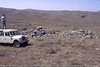
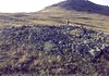
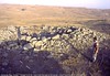
Kerkenes, a Phrygian city, is the largest pre-Hellenistic site on the Anatolian Plateau. The town had 7 kilometres of strong stone fortifications with 7 gates, that enclose 2.5 square kilometres. The city was burned, destroyed, and abandoned.
More information from the Middle East Technical University.
You may be viewing yesterday's version of this page. To see the most up to date information please register for a free account.
Do not use the above information on other web sites or publications without permission of the contributor.
Nearby Images from Flickr


The above images may not be of the site on this page, but were taken nearby. They are loaded from Flickr so please click on them for image credits.
Click here to see more info for this site
Nearby sites
Click here to view sites on an interactive map of the areaKey: Red: member's photo, Blue: 3rd party photo, Yellow: other image, Green: no photo - please go there and take one, Grey: site destroyed
Download sites to:
KML (Google Earth)
GPX (GPS waypoints)
CSV (Garmin/Navman)
CSV (Excel)
To unlock full downloads you need to sign up as a Contributory Member. Otherwise downloads are limited to 50 sites.
Turn off the page maps and other distractions
Nearby sites listing. In the following links * = Image available
7.0km N 355° Usakli Mound* Ancient Village or Settlement
10.8km SE 139° Cadir Hoyuk* Ancient Village or Settlement
23.3km WNW 291° Yozgat Ethnographic Museum Museum
23.5km SE 133° Alisar Hoyuk* Ancient Village or Settlement
26.0km ENE 76° Karakiz* Carving
39.2km SE 136° Sarikaya Roman Bath* Ancient Village or Settlement
41.7km NNW 341° Örükaya Roman Dam Ancient Mine, Quarry or other Industry
47.6km NW 310° Yazilikaya* Carving
48.4km NW 309° Hattuşa* Ancient Village or Settlement
51.6km NNW 332° Eskiyapar Ancient Village or Settlement
58.1km NNE 15° Shapinuwa Ancient Village or Settlement
60.6km NNW 330° Alacahöyük Hittite Dam* Misc. Earthwork
62.2km NNW 330° Alacahöyük* Ancient Village or Settlement
64.6km N 352° Pazarli Ancient Village or Settlement
74.5km NE 53° Masat Hoyuk Ancient Village or Settlement
82.0km WSW 246° Hashöyük Ancient Village or Settlement
85.0km SSW 194° Topakli Hoyuk Ancient Village or Settlement
88.4km N 354° Çorum Archaeological Museum Museum
91.1km NW 314° Boyali Hoyuk Ancient Village or Settlement
97.0km WSW 241° Yassihöyük Ancient Village or Settlement
100.8km NNE 28° Oluz Mound* Ancient Village or Settlement
102.3km SW 229° Kirsehir Museum Museum
109.9km SSW 208° Karaburna* Carving
111.5km SSE 153° Karum Kanes* Ancient Village or Settlement
111.6km SSE 153° Kültepe Kanes* Ancient Village or Settlement
View more nearby sites and additional images


 We would like to know more about this location. Please feel free to add a brief description and any relevant information in your own language.
 Wir möchten mehr über diese Stätte erfahren. Bitte zögern Sie nicht, eine kurze Beschreibung und relevante Informationen in Deutsch hinzuzufügen.
 Nous aimerions en savoir encore un peu sur les lieux. S'il vous plaît n'hesitez pas à ajouter une courte description et tous les renseignements pertinents dans votre propre langue.
 Quisieramos informarnos un poco más de las lugares. No dude en añadir una breve descripción y otros datos relevantes en su propio idioma.