


<< Our Photo Pages >> Netafim Neolithic sanctuary - Ancient Temple in Israel
Submitted by motist on Thursday, 15 July 2010 Page Views: 4939
Neolithic and Bronze AgeSite Name: Netafim Neolithic sanctuaryCountry: Israel
NOTE: This site is 9.658 km away from the location you searched for.
Type: Ancient Temple
Nearest Town: Eilat Nearest Village: Kibuts Eilot
Latitude: 29.593625N Longitude: 34.877713E
Condition:
| 5 | Perfect |
| 4 | Almost Perfect |
| 3 | Reasonable but with some damage |
| 2 | Ruined but still recognisable as an ancient site |
| 1 | Pretty much destroyed, possibly visible as crop marks |
| 0 | No data. |
| -1 | Completely destroyed |
| 5 | Superb |
| 4 | Good |
| 3 | Ordinary |
| 2 | Not Good |
| 1 | Awful |
| 0 | No data. |
| 5 | Can be driven to, probably with disabled access |
| 4 | Short walk on a footpath |
| 3 | Requiring a bit more of a walk |
| 2 | A long walk |
| 1 | In the middle of nowhere, a nightmare to find |
| 0 | No data. |
| 5 | co-ordinates taken by GPS or official recorded co-ordinates |
| 4 | co-ordinates scaled from a detailed map |
| 3 | co-ordinates scaled from a bad map |
| 2 | co-ordinates of the nearest village |
| 1 | co-ordinates of the nearest town |
| 0 | no data |
Internal Links:
External Links:
")
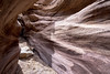
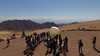
Wandering around i got to the Eastern margins of the site and sat down. The scenery of the landscape is beautiful facing east to the 'arava rift valley and the Edom mountain range in Jordan.
Looking around me on the ground i saw a terracotta figurine without head, but the hands was in ornate position (holding hands up to the heavens in prayer) and clearly feminine (see photo) so i started to look around and found the head and many votive articles made of terracotta, small miniature votive structures and bowls, chunk of a zoomorphic figurine and Red Sea shells.
In 1995 Dr. U. Avner and Mr. A. Holtser conducted an archaeological excavation and found no structure only some sea shells and bones of a fowl and of a quadruped.
I visited the excavation one day and found 2 more votive bowls.
Dr. Avner dated the site by the typology of the finding to the late 6Th millennium BCE.
You may be viewing yesterday's version of this page. To see the most up to date information please register for a free account.
Do not use the above information on other web sites or publications without permission of the contributor.
Nearby Images from Flickr

The above images may not be of the site on this page, but were taken nearby. They are loaded from Flickr so please click on them for image credits.
Click here to see more info for this site
Nearby sites
Click here to view sites on an interactive map of the areaKey: Red: member's photo, Blue: 3rd party photo, Yellow: other image, Green: no photo - please go there and take one, Grey: site destroyed
Download sites to:
KML (Google Earth)
GPX (GPS waypoints)
CSV (Garmin/Navman)
CSV (Excel)
To unlock full downloads you need to sign up as a Contributory Member. Otherwise downloads are limited to 50 sites.
Turn off the page maps and other distractions
Nearby sites listing. In the following links * = Image available
1.1km NE 34° North of Netafim spring* Ancient Temple
3.3km ENE 78° Roded cult sites* Ancient Temple
4.1km ENE 76° Wadi Roded Open Air Sanctuaries* Ancient Temple
4.3km E 91° Wadi Tawahin* Ancient Mine, Quarry or other Industry
4.9km ENE 71° Yedidyah pass Roded type cult site* Ancient Village or Settlement
6.6km SSE 152° Ramat Yotam 'roded' type site* Ancient Temple
6.7km N 360° Mount Uzia West Predators Trap* Misc. Earthwork
6.8km E 98° Shahmon Desert Kite* Misc. Earthwork
7.1km ENE 71° Shchoret habitation site* Ancient Village or Settlement
7.5km ENE 77° Shehoret Hills Desert Kite* Misc. Earthwork
7.9km ENE 75° Shchoret hills Open Air Mosque* Ancient Temple
8.1km E 81° Arround Shchoret hills* Ancient Village or Settlement
8.7km NNE 30° Upper Wadi Racham Camp* Standing Stones
9.6km NE 49° Mt. 'Amram Tumulus* Burial Chamber or Dolmen
10.2km NNE 15° North of Wadi Shani Masseboth* Standing Stones
10.8km NNE 29° Wadi Racham Matsebah* Standing Stones
11.1km N 4° SE' Se'ipim valley* Ancient Village or Settlement
11.3km S 186° Wadi Tweiba* Rock Art
12.1km NNE 18° Wadi 'Eteq Villas* Ancient Temple
12.2km N 7° E' Se'ipim valley* Ancient Village or Settlement
12.2km NNE 24° Flint workshop west of wadi Racham* Ancient Mine, Quarry or other Industry
12.3km NNE 25° S' of wadi 'Eteq* Ancient Temple
12.5km N 355° W' Se'ipim valley* Ancient Village or Settlement
13.2km NE 43° Nitsots hill open air sanctuary* Ancient Temple
13.5km N 1° Se'ipim Valley North Predators Trap* Misc. Earthwork
View more nearby sites and additional images


 We would like to know more about this location. Please feel free to add a brief description and any relevant information in your own language.
 Wir möchten mehr über diese Stätte erfahren. Bitte zögern Sie nicht, eine kurze Beschreibung und relevante Informationen in Deutsch hinzuzufügen.
 Nous aimerions en savoir encore un peu sur les lieux. S'il vous plaît n'hesitez pas à ajouter une courte description et tous les renseignements pertinents dans votre propre langue.
 Quisieramos informarnos un poco más de las lugares. No dude en añadir una breve descripción y otros datos relevantes en su propio idioma.