

<< Other Photo Pages >> Ramat Negev stone wine press - Ancient Mine, Quarry or other Industry in Israel
Submitted by motist on Tuesday, 25 July 2017 Page Views: 1228
Multi-periodSite Name: Ramat Negev stone wine press Alternative Name: Bir 'AslujCountry: Israel
NOTE: This site is 6.255 km away from the location you searched for.
Type: Ancient Mine, Quarry or other Industry
Nearest Town: Beer Sheva Nearest Village: Mashaby Sade
Latitude: 31.003414N Longitude: 34.768030E
Condition:
| 5 | Perfect |
| 4 | Almost Perfect |
| 3 | Reasonable but with some damage |
| 2 | Ruined but still recognisable as an ancient site |
| 1 | Pretty much destroyed, possibly visible as crop marks |
| 0 | No data. |
| -1 | Completely destroyed |
| 5 | Superb |
| 4 | Good |
| 3 | Ordinary |
| 2 | Not Good |
| 1 | Awful |
| 0 | No data. |
| 5 | Can be driven to, probably with disabled access |
| 4 | Short walk on a footpath |
| 3 | Requiring a bit more of a walk |
| 2 | A long walk |
| 1 | In the middle of nowhere, a nightmare to find |
| 0 | No data. |
| 5 | co-ordinates taken by GPS or official recorded co-ordinates |
| 4 | co-ordinates scaled from a detailed map |
| 3 | co-ordinates scaled from a bad map |
| 2 | co-ordinates of the nearest village |
| 1 | co-ordinates of the nearest town |
| 0 | no data |
Internal Links:
External Links:
")
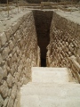
1,600-year-old stone wine press found in Ramat Negev
In the early Byzantine period Negev wines were perceived as boutique wines and highly esteemed, now a glimpse into their making is possible.
In the early Byzantine period Negev wines were perceived as boutique wines and highly esteemed, now a glimpse into their making is possible.
Together, they unearthed a 40 x 40 meters wine press (131 x 131 feet) complete with a stone pressing floor, a separation pit and a fermentation pool that could contain six and half cubic meters (6,500 Liters) of wine.
Haimi, who is in charge of an ongoing dig in Poland aimed to unearth the history of the Sobibor extermination camp, took a moment to speak to the Post while supervising the ancient wine press is kept hidden until the local council will decide what to do with it.
'Wine making at the time was done using human labor', he said, 'the workers would step on the grapes, then the pulp would be delivered to a basin where the clear liquid would surface and the dregs sink. This clear liquid is the Tirush' unfermented wine most Israelis associate with childhood Seder meals in which they were given the sweet, non-alcoholic Tirush, to drink the traditional four cups of wine.
"The tirush would be moved to fermentation pots. Negev wines were held at a very high esteem at the time, like the boutique wines of today,' said Haimi.
Wine production in the region went smoothly until a plague in the sixth century led to the decline of wine making in Southern Israel. The wine industry came to halt with the Arab conquest of the Levant and the end of the Byzantine period.
Anat Rasyuk from the Negev chapter of the Israeli Antiquity Authority said in a phone interview to the Jerusalem Post that the employment of students is a part of a larger educational effort meant to educate young Israelis about archeology.
'In some cases the students visit an active dig and help out', she explains, 'but in other cases this is a regular summer job. Students who happen to live next to an ongoing dig can apply to work there and be paid directly as they would in any other place. But when entire classes work they usually do so to support their schools.'
For example, she points out, 'some classes work to help ensure that all of their classmates have the funds to attend the educational tours in Poland. Their wages go to the school to fund the traveling expenses of students who would not otherwise be able to attend the program.'
The site had been covered to ensure it is protected until its future is decided upon. 'Ideally, it would be open to the pubic', said Rasyuk.
The Jerusalem Post By Hagay Hacohen
You may be viewing yesterday's version of this page. To see the most up to date information please register for a free account.
")
Do not use the above information on other web sites or publications without permission of the contributor.
Nearby Images from Flickr


The above images may not be of the site on this page, but were taken nearby. They are loaded from Flickr so please click on them for image credits.
Click here to see more info for this site
Nearby sites
Click here to view sites on an interactive map of the areaKey: Red: member's photo, Blue: 3rd party photo, Yellow: other image, Green: no photo - please go there and take one, Grey: site destroyed
Download sites to:
KML (Google Earth)
GPX (GPS waypoints)
CSV (Garmin/Navman)
CSV (Excel)
To unlock full downloads you need to sign up as a Contributory Member. Otherwise downloads are limited to 50 sites.
Turn off the page maps and other distractions
Nearby sites listing. In the following links * = Image available
10.3km ESE 113° Har Rakhama* Ancient Village or Settlement
13.7km S 171° The Lost City* Ancient Village or Settlement
15.0km NW 314° Haluza Ancient Village or Settlement
18.8km SW 224° Shivta National Park* Ancient Village or Settlement
21.1km S 189° Har Mihya* Rock Art
23.2km S 179° Tel 'Avdat* Ancient Village or Settlement
25.1km N 2° Bir Al Safadi* Ancient Village or Settlement
27.7km NNE 14° Tel Be'er Shev'a* Ancient Village or Settlement
28.3km E 85° Mamshit* Ancient Village or Settlement
30.5km N 4° Beer Sheva north* Ancient Village or Settlement
31.8km SW 216° Be'er Resisim* Ancient Village or Settlement
35.0km WSW 246° Tel Nitzana* Ancient Village or Settlement
36.1km NNE 21° Shoket Junction* Ancient Village or Settlement
36.3km ESE 107° Ma'ale-Akrabbim* Ancient Trackway
37.8km SSW 203° Wadi 'Akrav Petroglyphs* Rock Art
42.4km N 9° Khirbet Abu Hof (chaf)* Ancient Village or Settlement
44.5km NNW 340° Tel Haror Ancient Village or Settlement
45.3km S 170° Ramon crater open air sanctuary* Ancient Temple
45.4km SSE 160° Ramat Saharonim* Ancient Temple
45.5km SSW 194° Wadi Kabir Matseboth* Ancient Temple
45.8km NE 48° tel 'Arad* Ancient Village or Settlement
45.8km SSW 193° Wadi Kabir cistern* Ancient Mine, Quarry or other Industry
46.7km NNE 12° Khirbat Za'aq* Ancient Village or Settlement
47.3km SSE 160° Ein Saharonim* Stone Fort or Dun
47.6km SSE 163° Wadi Gvanim Ancient Bedouin cemetery* Barrow Cemetery
View more nearby sites and additional images


 We would like to know more about this location. Please feel free to add a brief description and any relevant information in your own language.
 Wir möchten mehr über diese Stätte erfahren. Bitte zögern Sie nicht, eine kurze Beschreibung und relevante Informationen in Deutsch hinzuzufügen.
 Nous aimerions en savoir encore un peu sur les lieux. S'il vous plaît n'hesitez pas à ajouter une courte description et tous les renseignements pertinents dans votre propre langue.
 Quisieramos informarnos un poco más de las lugares. No dude en añadir una breve descripción y otros datos relevantes en su propio idioma.