

<< Our Photo Pages >> Arapsun - Ancient Village or Settlement in Turkey
Submitted by AlexHunger on Friday, 12 October 2007 Page Views: 5529
Multi-periodSite Name: Arapsun Alternative Name: ZoropassosCountry: Turkey
NOTE: This site is 8.668 km away from the location you searched for.
Type: Ancient Village or Settlement
Nearest Town: Nevşehir Nearest Village: Gülşehir
Latitude: 38.745399N Longitude: 34.621700E
Condition:
| 5 | Perfect |
| 4 | Almost Perfect |
| 3 | Reasonable but with some damage |
| 2 | Ruined but still recognisable as an ancient site |
| 1 | Pretty much destroyed, possibly visible as crop marks |
| 0 | No data. |
| -1 | Completely destroyed |
| 5 | Superb |
| 4 | Good |
| 3 | Ordinary |
| 2 | Not Good |
| 1 | Awful |
| 0 | No data. |
| 5 | Can be driven to, probably with disabled access |
| 4 | Short walk on a footpath |
| 3 | Requiring a bit more of a walk |
| 2 | A long walk |
| 1 | In the middle of nowhere, a nightmare to find |
| 0 | No data. |
| 5 | co-ordinates taken by GPS or official recorded co-ordinates |
| 4 | co-ordinates scaled from a detailed map |
| 3 | co-ordinates scaled from a bad map |
| 2 | co-ordinates of the nearest village |
| 1 | co-ordinates of the nearest town |
| 0 | no data |
Be the first person to rate this site - see the 'Contribute!' box in the right hand menu.
Internal Links:
External Links:
")
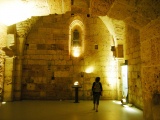
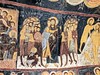
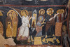
The origins of Arapsun, modern Gülşehir, date to about 7500 BCE judging from remains found in a cave. The town was ruled by the Hittites and then by the Phrygians, Persians, Greeks, then Romans. It became Zoropassos under the Byzantine empire.
You may be viewing yesterday's version of this page. To see the most up to date information please register for a free account.
Do not use the above information on other web sites or publications without permission of the contributor.
Nearby Images from Flickr

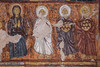
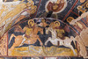
The above images may not be of the site on this page, but were taken nearby. They are loaded from Flickr so please click on them for image credits.
Click here to see more info for this site
Nearby sites
Click here to view sites on an interactive map of the areaKey: Red: member's photo, Blue: 3rd party photo, Yellow: other image, Green: no photo - please go there and take one, Grey: site destroyed
Download sites to:
KML (Google Earth)
GPX (GPS waypoints)
CSV (Garmin/Navman)
CSV (Excel)
To unlock full downloads you need to sign up as a Contributory Member. Otherwise downloads are limited to 50 sites.
Turn off the page maps and other distractions
Nearby sites listing. In the following links * = Image available
16.0km SSE 150° Nevsehir Underground City* Cave or Rock Shelter
20.8km NW 316° Karaburna* Carving
22.3km ESE 115° Rock Cones of Urgup (Cappadocia)* Natural Stone / Erratic / Other Natural Feature
30.6km SSW 204° Topada* Carving
30.7km WSW 250° Sivasa* Carving
32.0km WSW 242° Ovaören Mound* Ancient Village or Settlement
32.3km WSW 243° Topak Hoyuk* Ancient Village or Settlement
33.7km SSE 160° Kaymakli Underground City* Ancient Village or Settlement
34.1km NNE 31° Topakli Hoyuk Ancient Village or Settlement
42.5km SSE 167° Derinkuyu Underground City* Ancient Village or Settlement
43.3km SE 136° Sobessos* Ancient Village or Settlement
53.5km E 95° Örenşehir* Ancient Village or Settlement
54.3km S 187° Golludag* Ancient Village or Settlement
55.7km SW 218° Asikli Hoyuk* Ancient Village or Settlement
56.0km SW 218° Musular Ancient Village or Settlement
60.1km NW 318° Kirsehir Museum Museum
61.4km SSW 193° Divarli Hoyuk* Ancient Village or Settlement
64.7km S 190° Tepecik Çiftlik* Ancient Village or Settlement
68.8km NW 310° Malkaya* Carving
69.4km SW 232° Aksaray Museum* Museum
75.3km E 92° Kayseri Archaeological Museum* Museum
77.8km WSW 242° Acemhöyük* Ancient Village or Settlement
79.3km NW 324° Yassihöyük Ancient Village or Settlement
86.7km S 177° Nahita Ancient Village or Settlement
87.2km NNW 334° Hashöyük Ancient Village or Settlement
View more nearby sites and additional images

")
 We would like to know more about this location. Please feel free to add a brief description and any relevant information in your own language.
 Wir möchten mehr über diese Stätte erfahren. Bitte zögern Sie nicht, eine kurze Beschreibung und relevante Informationen in Deutsch hinzuzufügen.
 Nous aimerions en savoir encore un peu sur les lieux. S'il vous plaît n'hesitez pas à ajouter une courte description et tous les renseignements pertinents dans votre propre langue.
 Quisieramos informarnos un poco más de las lugares. No dude en añadir una breve descripción y otros datos relevantes en su propio idioma.