

<< Text Pages >> Tseri-Angali - Ancient Village or Settlement in Cyprus
Submitted by davidmorgan on Monday, 22 November 2010 Page Views: 4910
Multi-periodSite Name: Tseri-AngaliCountry: Cyprus
NOTE: This site is 13.041 km away from the location you searched for.
Type: Ancient Village or Settlement
Nearest Town: Nicosia Nearest Village: Tseri
Latitude: 35.062102N Longitude: 33.319333E
Condition:
| 5 | Perfect |
| 4 | Almost Perfect |
| 3 | Reasonable but with some damage |
| 2 | Ruined but still recognisable as an ancient site |
| 1 | Pretty much destroyed, possibly visible as crop marks |
| 0 | No data. |
| -1 | Completely destroyed |
| 5 | Superb |
| 4 | Good |
| 3 | Ordinary |
| 2 | Not Good |
| 1 | Awful |
| 0 | No data. |
| 5 | Can be driven to, probably with disabled access |
| 4 | Short walk on a footpath |
| 3 | Requiring a bit more of a walk |
| 2 | A long walk |
| 1 | In the middle of nowhere, a nightmare to find |
| 0 | No data. |
| 5 | co-ordinates taken by GPS or official recorded co-ordinates |
| 4 | co-ordinates scaled from a detailed map |
| 3 | co-ordinates scaled from a bad map |
| 2 | co-ordinates of the nearest village |
| 1 | co-ordinates of the nearest town |
| 0 | no data |
Be the first person to rate this site - see the 'Contribute!' box in the right hand menu.
Internal Links:
External Links:
Ancient Village or Settlement in Cyprus.
A settlement dating from the 7th century BCE discovered by local villagers in 1949. Lost and then rediscovered in 2006.
There have been recent excavations of a Roman cistern.
You may be viewing yesterday's version of this page. To see the most up to date information please register for a free account.
Do not use the above information on other web sites or publications without permission of the contributor.
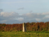
Nearby Images from Flickr


The above images may not be of the site on this page, but were taken nearby. They are loaded from Flickr so please click on them for image credits.
Click here to see more info for this site
Nearby sites
Click here to view sites on an interactive map of the areaKey: Red: member's photo, Blue: 3rd party photo, Yellow: other image, Green: no photo - please go there and take one, Grey: site destroyed
Download sites to:
KML (Google Earth)
GPX (GPS waypoints)
CSV (Garmin/Navman)
CSV (Excel)
To unlock full downloads you need to sign up as a Contributory Member. Otherwise downloads are limited to 50 sites.
Turn off the page maps and other distractions
Nearby sites listing. In the following links * = Image available
8.8km S 189° Kataliondas Kourvellos* Ancient Village or Settlement
10.7km ESE 119° Idalion Ancient Village or Settlement
11.1km SE 146° Ayia Varvara Asprokremnos Ancient Village or Settlement
11.3km SSW 212° Tamassos Ancient Village or Settlement
29.0km NNW 349° Karmi.* Chambered Tomb
29.6km S 176° Choirokoitia* Ancient Village or Settlement
31.5km NNE 17° Vrysi* Ancient Village or Settlement
32.3km ESE 119° Kition* Ancient Village or Settlement
32.3km ESE 119° Temple of Paphian Aphrodite* Ancient Temple
32.5km SE 127° Dromolaxia Vizatzia Ancient Village or Settlement
33.9km E 96° Pyla (Cyprus)* Ancient Temple
36.8km ESE 102° Pyla-Kokkinokremos Ancient Village or Settlement
39.5km SSW 199° Pyrgos-Mavrorachi Ancient Village or Settlement
42.3km SSW 205° Amathus* Ancient Village or Settlement
54.9km ENE 75° Salamis* Ancient Village or Settlement
59.2km SW 222° Kurion* Ancient Village or Settlement
77.1km SW 235° Petra Tou Romiou* Natural Stone / Erratic / Other Natural Feature
87.8km WSW 252° Lempa* Ancient Village or Settlement
88.2km WSW 253° Kissonerga-Skalia* Ancient Village or Settlement
88.8km W 270° Baths of Aphrodite Holy Well or Sacred Spring
89.2km WSW 249° Tombs of the Kings* Rock Cut Tomb
90.3km WSW 255° Maa-Palaeokastro Ancient Village or Settlement
92.7km W 272° Fontana Amorosa (Akamis Peninsula) Holy Well or Sacred Spring
116.8km NNW 336° Anemurium* Ancient Village or Settlement
132.0km NNE 18° Dana Island* Ancient Mine, Quarry or other Industry
View more nearby sites and additional images


 We would like to know more about this location. Please feel free to add a brief description and any relevant information in your own language.
 Wir möchten mehr über diese Stätte erfahren. Bitte zögern Sie nicht, eine kurze Beschreibung und relevante Informationen in Deutsch hinzuzufügen.
 Nous aimerions en savoir encore un peu sur les lieux. S'il vous plaît n'hesitez pas à ajouter une courte description et tous les renseignements pertinents dans votre propre langue.
 Quisieramos informarnos un poco más de las lugares. No dude en añadir una breve descripción y otros datos relevantes en su propio idioma.