


<< Our Photo Pages >> Philea Temple of Hathor - Ancient Temple in Egypt in Nubia
Submitted by AlexHunger on Saturday, 18 February 2006 Page Views: 8281
Roman, Greek and ClassicalSite Name: Philea Temple of HathorCountry: Egypt Region: Nubia Type: Ancient Temple
Nearest Town: Aswan Nearest Village: Philae Island
Latitude: 24.025510N Longitude: 32.884460E
Condition:
| 5 | Perfect |
| 4 | Almost Perfect |
| 3 | Reasonable but with some damage |
| 2 | Ruined but still recognisable as an ancient site |
| 1 | Pretty much destroyed, possibly visible as crop marks |
| 0 | No data. |
| -1 | Completely destroyed |
| 5 | Superb |
| 4 | Good |
| 3 | Ordinary |
| 2 | Not Good |
| 1 | Awful |
| 0 | No data. |
| 5 | Can be driven to, probably with disabled access |
| 4 | Short walk on a footpath |
| 3 | Requiring a bit more of a walk |
| 2 | A long walk |
| 1 | In the middle of nowhere, a nightmare to find |
| 0 | No data. |
| 5 | co-ordinates taken by GPS or official recorded co-ordinates |
| 4 | co-ordinates scaled from a detailed map |
| 3 | co-ordinates scaled from a bad map |
| 2 | co-ordinates of the nearest village |
| 1 | co-ordinates of the nearest town |
| 0 | no data |
Internal Links:
External Links:
I have visited· I would like to visit
Jansold visited on 3rd Mar 2003 - their rating: Cond: 4 Amb: 4 Access: 4
")
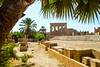
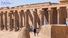
Small temple dedicated to Hathor as a mother goddess. There are nice reliefs of musicians and also of the god Bess, who was significant for childbirth.
You may be viewing yesterday's version of this page. To see the most up to date information please register for a free account.
")
Do not use the above information on other web sites or publications without permission of the contributor.
Nearby Images from Flickr

![Temple of Philae, Aswan, Egypt [Explored #351 on Thursday, April 18, 2024]](https://farm66.static.flickr.com/65535/53658915538_340b6e4f88_t.jpg)
The above images may not be of the site on this page, but were taken nearby. They are loaded from Flickr so please click on them for image credits.
Click here to see more info for this site
Nearby sites
Click here to view sites on an interactive map of the areaKey: Red: member's photo, Blue: 3rd party photo, Yellow: other image, Green: no photo - please go there and take one, Grey: site destroyed
Download sites to:
KML (Google Earth)
GPX (GPS waypoints)
CSV (Garmin/Navman)
CSV (Excel)
To unlock full downloads you need to sign up as a Contributory Member. Otherwise downloads are limited to 50 sites.
Turn off the page maps and other distractions
Nearby sites listing. In the following links * = Image available
1m E 90° Kiosk of Trajan* Ancient Temple
46m SSW 207° Philae Temple of Emhotep* Ancient Temple
68m SW 233° Philae Temple of Isis* Ancient Temple
4.0km NNW 340° Sehel Island* Rock Art
5.8km N 11° Aswan Broken Obelisk* Ancient Mine, Quarry or other Industry
6.1km N 6° Nubian Museum* Museum
6.5km N 2° Elephantine Temple of Khnum* Ancient Temple
6.6km N 2° Aswan Museum, Elephantine Island* Museum
6.6km N 3° Elephantine Island Nilometer* Ancient Mine, Quarry or other Industry
6.6km N 2° Temple of Satet* Ancient Temple
6.7km N 1° Elephantine Pyramid Pyramid / Mastaba
7.2km NNE 12° Qubbet el-Hawa Chambered Tomb
7.3km SSW 195° Temple of Beit El-Wali* Ancient Temple
7.4km NNW 332° Elephantine Island Hebrew Temple* Ancient Temple
7.4km SSW 193° Temple of Kalabsha* Ancient Temple
7.4km SSW 194° Temple of Dedwen* Ancient Temple
7.4km SSW 194° Stele of Seti I* Carving
7.4km SSW 194° Kiosk of Kertassi* Ancient Temple
7.4km SSW 194° Nubian Predynastic Reliefs* Carving
7.5km SSW 193° Temple of Gerf Hussein* Ancient Temple
8.5km N 3° Tomb of Harkhuf #34, Aswan* Rock Cut Tomb
8.5km N 3° Tomb of Sarenput II Tomb #31, Aswan* Rock Cut Tomb
8.5km N 3° Tomb of Pepi-nakht Tomb #35 Aswan* Rock Cut Tomb
8.5km N 3° Tombs of the Nobles, Aswan* Rock Cut Tomb
8.5km N 3° Tombs of Mekhu & Sabni #25 #26 (double tomb,) Aswan* Rock Cut Tomb
View more nearby sites and additional images


 We would like to know more about this location. Please feel free to add a brief description and any relevant information in your own language.
 Wir möchten mehr über diese Stätte erfahren. Bitte zögern Sie nicht, eine kurze Beschreibung und relevante Informationen in Deutsch hinzuzufügen.
 Nous aimerions en savoir encore un peu sur les lieux. S'il vous plaît n'hesitez pas à ajouter une courte description et tous les renseignements pertinents dans votre propre langue.
 Quisieramos informarnos un poco más de las lugares. No dude en añadir una breve descripción y otros datos relevantes en su propio idioma.