

<< Our Photo Pages >> Tareen basin and cup marks - Carving in Sudan
Submitted by KaiHofmann on Tuesday, 09 December 2014 Page Views: 2337
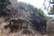
Multi-periodSite Name: Tareen basin and cup marksCountry: Sudan
NOTE: This site is 365.594 km away from the location you searched for.
Type: Carving
Nearest Town: Laqawa Nearest Village: Tareen
Latitude: 11.425317N Longitude: 29.161885E
Condition:
| 5 | Perfect |
| 4 | Almost Perfect |
| 3 | Reasonable but with some damage |
| 2 | Ruined but still recognisable as an ancient site |
| 1 | Pretty much destroyed, possibly visible as crop marks |
| 0 | No data. |
| -1 | Completely destroyed |
| 5 | Superb |
| 4 | Good |
| 3 | Ordinary |
| 2 | Not Good |
| 1 | Awful |
| 0 | No data. |
| 5 | Can be driven to, probably with disabled access |
| 4 | Short walk on a footpath |
| 3 | Requiring a bit more of a walk |
| 2 | A long walk |
| 1 | In the middle of nowhere, a nightmare to find |
| 0 | No data. |
| 5 | co-ordinates taken by GPS or official recorded co-ordinates |
| 4 | co-ordinates scaled from a detailed map |
| 3 | co-ordinates scaled from a bad map |
| 2 | co-ordinates of the nearest village |
| 1 | co-ordinates of the nearest town |
| 0 | no data |
Internal Links:
External Links:
")
A large ancient water basin and many oval shape cup marks on the hill north of the small village Tareen.
You may be viewing yesterday's version of this page. To see the most up to date information please register for a free account.
")
")
")
")
Do not use the above information on other web sites or publications without permission of the contributor.
Click here to see more info for this site
Nearby sites
Click here to view sites on an interactive map of the areaKey: Red: member's photo, Blue: 3rd party photo, Yellow: other image, Green: no photo - please go there and take one, Grey: site destroyed
Download sites to:
KML (Google Earth)
GPX (GPS waypoints)
CSV (Garmin/Navman)
CSV (Excel)
To unlock full downloads you need to sign up as a Contributory Member. Otherwise downloads are limited to 50 sites.
Turn off the page maps and other distractions
Nearby sites listing. In the following links * = Image available
5.3km WNW 281° Warina ancient settlement* Ancient Village or Settlement
24.4km SW 221° Dar Kabira Paintings* Rock Art
24.5km SW 220° Dar Kabira settlement* Ancient Village or Settlement
589.1km NE 38° Sudan National Museum Museum
743.9km NNE 18° Wadi Abu Dom Rock Art Rock Art
745.0km NE 38° El Kadada Neolithic Tomb Burial Chamber or Dolmen
780.9km NE 39° Abu Erteila Ancient Temple
784.8km NE 38° Meroë* Ancient Village or Settlement
787.5km NE 38° Meroë Pyramids* Pyramid / Mastaba
820.4km NNE 19° Zuma Tumuli Round Barrow(s)
823.1km NNE 19° El-Kurru Tumuli Round Barrow(s)
823.8km NNE 19° El-Kurru Pyramids* Pyramid / Mastaba
834.9km NNE 20° Sanam Temple Ancient Temple
839.8km NNE 20° Gebel Barkal Temple of Mut Ancient Temple
839.8km NNE 20° Gebel Barkal Temple B700 Ancient Temple
840.9km NNE 20° Gebel Barkal Temple of Amon* Ancient Temple
840.9km NNE 20° Karima Pyramids* Pyramid / Mastaba
841.0km NNE 20° Gebel Barkal Mountain and Rock Formation* Natural Stone / Erratic / Other Natural Feature
847.1km NNE 20° Nuri Pyramids* Pyramid / Mastaba
889.5km E 83° Gorgora Rock Shelter* Cave or Rock Shelter
908.2km NE 34° Statue of Taharqa Carving
977.1km N 9° Sesebi* Ancient Village or Settlement
997.9km NW 307° Terkéï Massif Rock Art* Rock Art
1009.5km N 7° Soleb* Ancient Temple
1022.2km N 7° Sedeinga* Pyramid / Mastaba
View more nearby sites and additional images


 We would like to know more about this location. Please feel free to add a brief description and any relevant information in your own language.
 Wir möchten mehr über diese Stätte erfahren. Bitte zögern Sie nicht, eine kurze Beschreibung und relevante Informationen in Deutsch hinzuzufügen.
 Nous aimerions en savoir encore un peu sur les lieux. S'il vous plaît n'hesitez pas à ajouter une courte description et tous les renseignements pertinents dans votre propre langue.
 Quisieramos informarnos un poco más de las lugares. No dude en añadir una breve descripción y otros datos relevantes en su propio idioma.