

<< Other Photo Pages >> Gerzeh cemetery - Barrow Cemetery in Egypt in Upper Egypt (South)
Submitted by Andy B on Saturday, 01 June 2013 Page Views: 6044
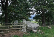
Neolithic and Bronze AgeSite Name: Gerzeh cemetery Alternative Name: Girza, Jirzah, Tomb 80, Tomb 67, Tomb 105, Tomb 205Country: Egypt Region: Upper Egypt (South) Type: Barrow Cemetery
Nearest Town: al-Girza
Latitude: 29.450000N Longitude: 31.200000E
Condition:
| 5 | Perfect |
| 4 | Almost Perfect |
| 3 | Reasonable but with some damage |
| 2 | Ruined but still recognisable as an ancient site |
| 1 | Pretty much destroyed, possibly visible as crop marks |
| 0 | No data. |
| -1 | Completely destroyed |
| 5 | Superb |
| 4 | Good |
| 3 | Ordinary |
| 2 | Not Good |
| 1 | Awful |
| 0 | No data. |
| 5 | Can be driven to, probably with disabled access |
| 4 | Short walk on a footpath |
| 3 | Requiring a bit more of a walk |
| 2 | A long walk |
| 1 | In the middle of nowhere, a nightmare to find |
| 0 | No data. |
| 5 | co-ordinates taken by GPS or official recorded co-ordinates |
| 4 | co-ordinates scaled from a detailed map |
| 3 | co-ordinates scaled from a bad map |
| 2 | co-ordinates of the nearest village |
| 1 | co-ordinates of the nearest town |
| 0 | no data |
Internal Links:
External Links:
I have visited· I would like to visit
Andy B has visited here
")
At the beginning of 1911 Gerald Wainwright was working for Flanders Petrie, helping excavate the tomb area north of Meydum Near the village of Gerzeh he found a cemetery with many intact tombs from the Pre-Dynastic era. It was particularly the middle years of this period – c. 3600-3300 BC – which were represented, and Petrie, accordingly, called the period Gerzean. The finds from Gerzeh were of great interest since it was the first time that finds from this period had been made so far north in Egypt.
The tombs were principally rectangular or oval graves. The burial lay in the foetal position, surrounded by grave-goods: jars of pottery or stone, together with, in certain cases, strings of beads made of semi-precious stones and faience. The jars were filled with, or represented, food drink and fragrant ointments and oils. Many of the tombs contained small, miniature stone jars
The Gerzean is the second of three phases of the Naqada Culture, and so is called Naqada II. It is preceded by the Amratian (Naqada I) and followed by the Protodynastic or Semainian (Naqada III).
For more on the Gerzeh culture see Wikipedia, for more on the various tombs of the cemetary see Digital Egypt. Info also sourced also from the Pitrie project.
NOTE: Although we have listed as a 'barrow' cemetery, there are not any significant above ground barrows as far as we know.
Note: Predynastic Egyptians accessorised with iron beads made from meteorites
You may be viewing yesterday's version of this page. To see the most up to date information please register for a free account.
")
")
")
Do not use the above information on other web sites or publications without permission of the contributor.
Nearby Images from Flickr

The above images may not be of the site on this page, but were taken nearby. They are loaded from Flickr so please click on them for image credits.
Click here to see more info for this site
Nearby sites
Click here to view sites on an interactive map of the areaKey: Red: member's photo, Blue: 3rd party photo, Yellow: other image, Green: no photo - please go there and take one, Grey: site destroyed
Download sites to:
KML (Google Earth)
GPX (GPS waypoints)
CSV (Garmin/Navman)
CSV (Excel)
To unlock full downloads you need to sign up as a Contributory Member. Otherwise downloads are limited to 50 sites.
Turn off the page maps and other distractions
Nearby sites listing. In the following links * = Image available
7.7km SSW 212° Rahotep Mastaba* Chambered Cairn
8.0km SSW 211° Meidum Mastaba* Pyramid / Mastaba
8.0km SSW 211° Meidum Broken Pyramid* Pyramid / Mastaba
12.4km N 9° Senusret I Pyramid Pyramid / Mastaba
14.1km N 10° Amenemhat I Pyramid Pyramid / Mastaba
16.0km WSW 242° Seila Pyramid Pyramid / Mastaba
29.8km WNW 285° Karanis Aushim Temple* Ancient Temple
32.5km SW 223° Al Lahoun Mastabas* Pyramid / Mastaba
32.5km SW 223° Senusret II Pyramid* Pyramid / Mastaba
32.6km N 3° Mazghuna 2 Pyramid Pyramid / Mastaba
32.7km N 3° Mazghuna 1 Pyramid Pyramid / Mastaba
35.1km SW 236° Amenmenhat III Pyramid at Hawwara* Pyramid / Mastaba
35.3km WSW 236° Hawwara Necropolis* Barrow Cemetery
37.7km N 1° Queen Hetepheres Pyramid* Pyramid / Mastaba
37.9km N 1° Sneferu's Bent Pyramid* Pyramid / Mastaba
38.0km N 3° Amenemhat III Pyramid at Dashour.* Pyramid / Mastaba
38.4km N 2° Dashour Valley Temple* Ancient Temple
38.5km WSW 247° Egypt's Earliest Farm Settlement Discovered Ancient Village or Settlement
39.8km N 3° Amenmenhat II Pyramid Pyramid / Mastaba
39.9km N 1° Red Pyramid* Pyramid / Mastaba
41.1km N 3° Senusret III Pyramid Pyramid / Mastaba
42.4km N 3° Khendjer's Pyramid Pyramid / Mastaba
43.3km N 2° Shepseskaf's Mastaba* Pyramid / Mastaba
43.4km N 2° Pepy II Pyramid* Pyramid / Mastaba
43.6km N 2° Ibi I Pyramid Pyramid / Mastaba
View more nearby sites and additional images


 We would like to know more about this location. Please feel free to add a brief description and any relevant information in your own language.
 Wir möchten mehr über diese Stätte erfahren. Bitte zögern Sie nicht, eine kurze Beschreibung und relevante Informationen in Deutsch hinzuzufügen.
 Nous aimerions en savoir encore un peu sur les lieux. S'il vous plaît n'hesitez pas à ajouter une courte description et tous les renseignements pertinents dans votre propre langue.
 Quisieramos informarnos un poco más de las lugares. No dude en añadir una breve descripción y otros datos relevantes en su propio idioma.