


<< Our Photo Pages >> Sanctuary of Eurymedon - Cave or Rock Shelter in Turkey
Submitted by davidmorgan on Friday, 15 February 2008 Page Views: 7134
Natural PlacesSite Name: Sanctuary of Eurymedon Alternative Name: Zindan Mağarası, Tymbriada, Zindan CaveCountry: Turkey
NOTE: This site is 22.258 km away from the location you searched for.
Type: Cave or Rock Shelter
Nearest Town: Eğirdir Nearest Village: Aksu
Latitude: 37.811522N Longitude: 31.085408E
Condition:
| 5 | Perfect |
| 4 | Almost Perfect |
| 3 | Reasonable but with some damage |
| 2 | Ruined but still recognisable as an ancient site |
| 1 | Pretty much destroyed, possibly visible as crop marks |
| 0 | No data. |
| -1 | Completely destroyed |
| 5 | Superb |
| 4 | Good |
| 3 | Ordinary |
| 2 | Not Good |
| 1 | Awful |
| 0 | No data. |
| 5 | Can be driven to, probably with disabled access |
| 4 | Short walk on a footpath |
| 3 | Requiring a bit more of a walk |
| 2 | A long walk |
| 1 | In the middle of nowhere, a nightmare to find |
| 0 | No data. |
| 5 | co-ordinates taken by GPS or official recorded co-ordinates |
| 4 | co-ordinates scaled from a detailed map |
| 3 | co-ordinates scaled from a bad map |
| 2 | co-ordinates of the nearest village |
| 1 | co-ordinates of the nearest town |
| 0 | no data |
Internal Links:
External Links:
I have visited· I would like to visit
davidmorgan has visited here
")
A Roman sanctuary of the river god Eurymedon, a statue of whom was found here and is now in the Isparta museum.
You may be viewing yesterday's version of this page. To see the most up to date information please register for a free account.
")
")
")
Do not use the above information on other web sites or publications without permission of the contributor.
Nearby Images from Flickr

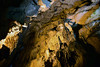
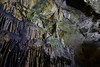
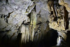
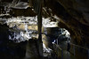

The above images may not be of the site on this page, but were taken nearby. They are loaded from Flickr so please click on them for image credits.
Click here to see more info for this site
Nearby sites
Click here to view sites on an interactive map of the areaKey: Red: member's photo, Blue: 3rd party photo, Yellow: other image, Green: no photo - please go there and take one, Grey: site destroyed
Download sites to:
KML (Google Earth)
GPX (GPS waypoints)
CSV (Garmin/Navman)
CSV (Excel)
To unlock full downloads you need to sign up as a Contributory Member. Otherwise downloads are limited to 50 sites.
Turn off the page maps and other distractions
Nearby sites listing. In the following links * = Image available
28.0km SSW 199° Adada (Pisidia)* Ancient Village or Settlement
39.8km NE 46° Arakli Mound Ancient Village or Settlement
49.4km SW 225° Cremna* Ancient Village or Settlement
51.7km E 88° Eflatun Pinar* Holy Well or Sacred Spring
52.1km WSW 253° Sagalassos* Ancient Village or Settlement
54.4km NNE 13° Temple of Men Askaenos* Ancient Temple
55.6km N 9° Pisidian Antioch* Ancient Village or Settlement
63.6km SSW 207° Milyos* Ancient Village or Settlement
64.9km S 177° Selge* Ancient Village or Settlement
67.3km S 191° Pednelissos* Ancient Village or Settlement
70.4km NW 313° Tatarli Tumulus Artificial Mound
71.0km W 262° Burdur Museum Museum
73.4km ESE 103° Fasillar* Carving
74.8km SW 215° Sia (Pisidia) Ancient Village or Settlement
79.8km SW 220° Panemoteichos* Ancient Village or Settlement
82.0km SSW 213° Doseme Bogazi* Ancient Trackway
83.2km WSW 257° Kurucay Hoyuk* Ancient Village or Settlement
83.5km SW 219° Bademagaci Hoyuk* Ancient Village or Settlement
88.5km SW 218° Ariassos* Ancient Village or Settlement
91.5km S 185° Sillyon* Ancient Village or Settlement
91.6km WSW 254° Hacilar* Ancient Village or Settlement
93.5km SSW 209° Karain Cave* Cave or Rock Shelter
95.9km SSE 160° Etenna Ancient Village or Settlement
96.7km SSW 192° Perge* Ancient Village or Settlement
97.3km S 175° Aspendos* Ancient Village or Settlement
View more nearby sites and additional images


 We would like to know more about this location. Please feel free to add a brief description and any relevant information in your own language.
 Wir möchten mehr über diese Stätte erfahren. Bitte zögern Sie nicht, eine kurze Beschreibung und relevante Informationen in Deutsch hinzuzufügen.
 Nous aimerions en savoir encore un peu sur les lieux. S'il vous plaît n'hesitez pas à ajouter une courte description et tous les renseignements pertinents dans votre propre langue.
 Quisieramos informarnos un poco más de las lugares. No dude en añadir una breve descripción y otros datos relevantes en su propio idioma.