

, Aubrey Burl")
<< Text Pages >> Pismis Kale - Hillfort in Turkey
Submitted by davidmorgan on Wednesday, 19 February 2020 Page Views: 459
Iron Age and Later PrehistorySite Name: Pismis Kale Alternative Name: Pişmiş KaleCountry: Turkey
NOTE: This site is 12.369 km away from the location you searched for.
Type: Hillfort
Nearest Town: Afyon Nearest Village: Çukurca
Latitude: 39.215600N Longitude: 30.725800E
Condition:
| 5 | Perfect |
| 4 | Almost Perfect |
| 3 | Reasonable but with some damage |
| 2 | Ruined but still recognisable as an ancient site |
| 1 | Pretty much destroyed, possibly visible as crop marks |
| 0 | No data. |
| -1 | Completely destroyed |
| 5 | Superb |
| 4 | Good |
| 3 | Ordinary |
| 2 | Not Good |
| 1 | Awful |
| 0 | No data. |
| 5 | Can be driven to, probably with disabled access |
| 4 | Short walk on a footpath |
| 3 | Requiring a bit more of a walk |
| 2 | A long walk |
| 1 | In the middle of nowhere, a nightmare to find |
| 0 | No data. |
| 5 | co-ordinates taken by GPS or official recorded co-ordinates |
| 4 | co-ordinates scaled from a detailed map |
| 3 | co-ordinates scaled from a bad map |
| 2 | co-ordinates of the nearest village |
| 1 | co-ordinates of the nearest town |
| 0 | no data |
Internal Links:
External Links:
Hillfort in Eskişehir Province, Turkey
A Phrygian fortified rock outcrop which features carved stairs.
You may be viewing yesterday's version of this page. To see the most up to date information please register for a free account.
Do not use the above information on other web sites or publications without permission of the contributor.
Nearby Images from Flickr
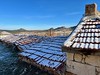
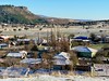
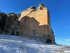
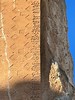
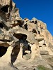
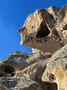
The above images may not be of the site on this page, but were taken nearby. They are loaded from Flickr so please click on them for image credits.
Click here to see more info for this site
Nearby sites
Click here to view sites on an interactive map of the areaKey: Red: member's photo, Blue: 3rd party photo, Yellow: other image, Green: no photo - please go there and take one, Grey: site destroyed
Download sites to:
KML (Google Earth)
GPX (GPS waypoints)
CSV (Garmin/Navman)
CSV (Excel)
To unlock full downloads you need to sign up as a Contributory Member. Otherwise downloads are limited to 50 sites.
Turn off the page maps and other distractions
Nearby sites listing. In the following links * = Image available
1.4km W 280° Areyastis Monument* Sculptured Stone
2.1km SSW 211° Midas City* Ancient Village or Settlement
2.7km WNW 295° Gerdek Kaya* Rock Cut Tomb
10.1km W 271° Kümbet North Tomb* Rock Cut Tomb
10.2km W 267° Kümbet Lion Tomb* Rock Cut Tomb
10.2km W 268° Kümbet Rock Sanctuary* Ancient Temple
25.5km SW 223° Aslantas* Carving
25.5km SW 223° Yilantas* Rock Cut Tomb
26.2km SW 223° Maltas* Rock Cut Tomb
28.3km WSW 244° Aslankaya* Carving
37.9km N 2° Kulluoba Hoyuk Ancient Village or Settlement
54.2km SSW 196° Afyon Archaeological Museum* Museum
74.9km E 80° Pessinous* Ancient Temple
80.7km NNW 331° Demircihoyuk Ancient Village or Settlement
84.5km WNW 299° Seyitömer Höyük* Ancient Village or Settlement
96.2km W 269° Aizanoi* Ancient Village or Settlement
101.6km E 79° Yagri* Ancient Village or Settlement
108.9km SSE 158° Pisidian Antioch* Ancient Village or Settlement
110.1km S 190° Tatarli Tumulus Artificial Mound
111.7km SSE 157° Temple of Men Askaenos* Ancient Temple
117.9km ENE 65° Gordion* Ancient Village or Settlement
119.5km ENE 66° Gordion Museum Museum
119.6km ENE 66° Midas Tumulus* Artificial Mound
121.0km NNW 329° Bilecik* Ancient Village or Settlement
123.3km WNW 291° Deliklitaş Sculptured Stone
View more nearby sites and additional images


 We would like to know more about this location. Please feel free to add a brief description and any relevant information in your own language.
 Wir möchten mehr über diese Stätte erfahren. Bitte zögern Sie nicht, eine kurze Beschreibung und relevante Informationen in Deutsch hinzuzufügen.
 Nous aimerions en savoir encore un peu sur les lieux. S'il vous plaît n'hesitez pas à ajouter une courte description et tous les renseignements pertinents dans votre propre langue.
 Quisieramos informarnos un poco más de las lugares. No dude en añadir una breve descripción y otros datos relevantes en su propio idioma.