


<< Text Pages >> Dimeh Al-Siba - Ancient Village or Settlement in Egypt in Lower Egypt (North)
Submitted by jackdaw1 on Friday, 07 December 2012 Page Views: 3528
Multi-periodSite Name: Dimeh Al-Siba Alternative Name: Soknopaios TempleCountry: Egypt Region: Lower Egypt (North) Type: Ancient Village or Settlement
Nearest Town: Fayoum Nearest Village: Qarun Lake
Latitude: 29.535757N Longitude: 30.668629E
Condition:
| 5 | Perfect |
| 4 | Almost Perfect |
| 3 | Reasonable but with some damage |
| 2 | Ruined but still recognisable as an ancient site |
| 1 | Pretty much destroyed, possibly visible as crop marks |
| 0 | No data. |
| -1 | Completely destroyed |
| 5 | Superb |
| 4 | Good |
| 3 | Ordinary |
| 2 | Not Good |
| 1 | Awful |
| 0 | No data. |
| 5 | Can be driven to, probably with disabled access |
| 4 | Short walk on a footpath |
| 3 | Requiring a bit more of a walk |
| 2 | A long walk |
| 1 | In the middle of nowhere, a nightmare to find |
| 0 | No data. |
| 5 | co-ordinates taken by GPS or official recorded co-ordinates |
| 4 | co-ordinates scaled from a detailed map |
| 3 | co-ordinates scaled from a bad map |
| 2 | co-ordinates of the nearest village |
| 1 | co-ordinates of the nearest town |
| 0 | no data |
Be the first person to rate this site - see the 'Contribute!' box in the right hand menu.
Internal Links:
External Links:
Ancient Town in Lower Egypt (North)
The Italian archaeological mission of Salento-Litchi University has found a pair of gigantic seated lion statues on Monday. They were found erected at the entrance of Soknopaios Temple at the Ptolemaic town, Dimeh Al-Siba, in Fayoum.
Dimeh Al-Siba, which means ‘Island of the Crocodile god,’ is located eleven kilometres to the north of Qarun Lake. It was founded by Ptolemy II on top of a Neolithic residential area.
The Ptolemaic-era town contains a collection of residential houses, a large temple to worship Sknopaios, in ancient Egypt Sobek-en-Pai (crocodile), a bakery and a market.
During excavation work carried out by archaeologist and director of the Italian mission, Mario Capasso, a pair of lion statues appeared on the sand surface.
The lion statues are skillfully carved of limestone and were presumably used to decorate the entrance gate of the temple.
Mohamed Ibrahim, Antiquities Minister, describes the discovery as interesting, as it confirm that the temple was constructed according to an architectural plan used in main temples in large cities and capital.
“It is also the first time that the gigantic lion shaped statues have been unearthed in a small Greco-Roman settlement in Fayoum,” said Ibrahim
Both statues are in a very well-preserved condition and are now at the Fayoum storehouse for restoration.
More, with photos at Ahram.org
You may be viewing yesterday's version of this page. To see the most up to date information please register for a free account.
Do not use the above information on other web sites or publications without permission of the contributor.
Nearby Images from Flickr
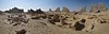
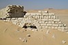

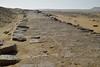

The above images may not be of the site on this page, but were taken nearby. They are loaded from Flickr so please click on them for image credits.
Click here to see more info for this site
Nearby sites
Click here to view sites on an interactive map of the areaKey: Red: member's photo, Blue: 3rd party photo, Yellow: other image, Green: no photo - please go there and take one, Grey: site destroyed
Download sites to:
KML (Google Earth)
GPX (GPS waypoints)
CSV (Garmin/Navman)
CSV (Excel)
To unlock full downloads you need to sign up as a Contributory Member. Otherwise downloads are limited to 50 sites.
Turn off the page maps and other distractions
Nearby sites listing. In the following links * = Image available
2.3km WNW 293° Possible Pyramids near Kafr Al Masallat* Pyramid / Mastaba
6.7km N 8° Qasr el- Sagha* Ancient Temple
14.4km NNW 342° Widan el-Faras Ancient Mine, Quarry or other Industry
22.7km E 95° Karanis Aushim Temple* Ancient Temple
29.1km SSE 147° Egypt's Earliest Farm Settlement Discovered Ancient Village or Settlement
36.6km SE 143° Hawwara Necropolis* Barrow Cemetery
36.7km SE 142° Amenmenhat III Pyramid at Hawwara* Pyramid / Mastaba
38.1km S 184° Medinet Maadi temple of Renenutet Ancient Temple
41.0km ESE 114° Seila Pyramid Pyramid / Mastaba
44.3km SE 139° Al Lahoun Mastabas* Pyramid / Mastaba
44.4km SE 139° Senusret II Pyramid* Pyramid / Mastaba
50.0km ESE 109° Rahotep Mastaba* Chambered Cairn
50.0km ESE 109° Meidum Mastaba* Pyramid / Mastaba
50.0km ESE 109° Meidum Broken Pyramid* Pyramid / Mastaba
52.3km E 100° Gerzeh cemetery* Barrow Cemetery
53.5km E 87° Senusret I Pyramid Pyramid / Mastaba
54.0km E 85° Amenemhat I Pyramid Pyramid / Mastaba
58.0km ENE 66° Mazghuna 2 Pyramid Pyramid / Mastaba
58.0km ENE 66° Mazghuna 1 Pyramid Pyramid / Mastaba
59.4km ENE 62° Queen Hetepheres Pyramid* Pyramid / Mastaba
59.4km ENE 61° Sneferu's Bent Pyramid* Pyramid / Mastaba
60.2km ENE 60° Red Pyramid* Pyramid / Mastaba
60.3km ENE 61° Dashour Valley Temple* Ancient Temple
60.7km ENE 62° Amenemhat III Pyramid at Dashour.* Pyramid / Mastaba
61.4km ENE 60° Amenmenhat II Pyramid Pyramid / Mastaba
View more nearby sites and additional images


 We would like to know more about this location. Please feel free to add a brief description and any relevant information in your own language.
 Wir möchten mehr über diese Stätte erfahren. Bitte zögern Sie nicht, eine kurze Beschreibung und relevante Informationen in Deutsch hinzuzufügen.
 Nous aimerions en savoir encore un peu sur les lieux. S'il vous plaît n'hesitez pas à ajouter une courte description et tous les renseignements pertinents dans votre propre langue.
 Quisieramos informarnos un poco más de las lugares. No dude en añadir una breve descripción y otros datos relevantes en su propio idioma.