


<< Other Photo Pages >> La Pierre-des-Fievres - Burial Chamber or Dolmen in France in Auvergne:Haute-Loire (43)
Submitted by TheCaptain on Wednesday, 08 September 2010 Page Views: 3049
Neolithic and Bronze AgeSite Name: La Pierre-des-Fievres Alternative Name: Dolmen dit la Pierre des FièvresCountry: France
NOTE: This site is 3.401 km away from the location you searched for.
Département: Auvergne:Haute-Loire (43) Type: Burial Chamber or Dolmen
Nearest Town: Le Puy-en-Velay Nearest Village: Le Puy-en-Velay
Latitude: 45.045600N Longitude: 3.884300E
Condition:
| 5 | Perfect |
| 4 | Almost Perfect |
| 3 | Reasonable but with some damage |
| 2 | Ruined but still recognisable as an ancient site |
| 1 | Pretty much destroyed, possibly visible as crop marks |
| 0 | No data. |
| -1 | Completely destroyed |
| 5 | Superb |
| 4 | Good |
| 3 | Ordinary |
| 2 | Not Good |
| 1 | Awful |
| 0 | No data. |
| 5 | Can be driven to, probably with disabled access |
| 4 | Short walk on a footpath |
| 3 | Requiring a bit more of a walk |
| 2 | A long walk |
| 1 | In the middle of nowhere, a nightmare to find |
| 0 | No data. |
| 5 | co-ordinates taken by GPS or official recorded co-ordinates |
| 4 | co-ordinates scaled from a detailed map |
| 3 | co-ordinates scaled from a bad map |
| 2 | co-ordinates of the nearest village |
| 1 | co-ordinates of the nearest town |
| 0 | no data |
Internal Links:
External Links:
I have visited· I would like to visit
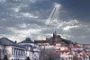
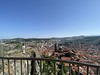
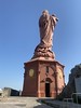
TheCaptain visited on 28th Jul 2005 - their rating: Cond: 1 Access: 4 The Cathedral of Puy-en-Velay is said to be built on the site of an ancient dolmen, part of which is still in existance as La Pierre des Fievres which is kept and presented near to one of the entrances. It is said that this stone is a part of the coverstone for the dolmen which stood in this sacred place for thousands of years before the coming of Christianity. It is believed that the dolmen was complete until the 9th century, when it was broken by a bolt of lightning, but that the Pilgrims to this place ensured that a part of it was kept here. The stone is highly venerated, and many miracles are attributed to it, including many which involve curing fever, after which it is named. For many years the stone was kept within the Cathedral, but then was put in a place outside so that ill people could have easier access to touch it. To this day, the Cathedral and a dolmen are a symbol of this town of Pilgrimmage, which is an important stopping place on the way of St James.
")
It is believed that the dolmen was complete until the 9th century, when it was broken by a bolt of lightning, but that the Pilgrims to this place ensured that a part of it was kept here.
The stone is highly venerated, and many miracles are attributed to it, including many which involve curing fever, after which it is named. For many years the stone was kept within the Cathedral, but then was put in a place outside so that ill people could have easier access to touch it.
To this day, the Cathedral and a dolmen are a symbol of this town of Pilgrimmage, which is an important stopping place on the way of St James.
You may be viewing yesterday's version of this page. To see the most up to date information please register for a free account.
Do not use the above information on other web sites or publications without permission of the contributor.
TheCaptain has found this location on Google Street View:
Nearby Images from Flickr


The above images may not be of the site on this page, but were taken nearby. They are loaded from Flickr so please click on them for image credits.
Click here to see more info for this site
Nearby sites
Click here to view sites on an interactive map of the areaKey: Red: member's photo, Blue: 3rd party photo, Yellow: other image, Green: no photo - please go there and take one, Grey: site destroyed
Download sites to:
KML (Google Earth)
GPX (GPS waypoints)
CSV (Garmin/Navman)
CSV (Excel)
To unlock full downloads you need to sign up as a Contributory Member. Otherwise downloads are limited to 50 sites.
Turn off the page maps and other distractions
Nearby sites listing. In the following links * = Image available
499m NNW 344° Dolmen de Saint-Michel d'Aiguilhe* Burial Chamber or Dolmen
8.2km NW 326° Menhir de la Peyrebiaire* Standing Stone (Menhir)
9.1km NNE 17° Lou-Donat* Standing Stone (Menhir)
10.9km S 172° Dolmen de Collandre Burial Chamber or Dolmen
12.2km SW 228° Dolmen de Séneujols* Burial Chamber or Dolmen
17.5km E 85° Pierre à Cupules de Monedeyre Rock Art
19.9km SSE 167° Camp Celtique d’Antoune Ancient Village or Settlement
21.3km NNE 23° Artites Dolmen Burial Chamber or Dolmen
23.8km E 88° Chièze Menhir* Standing Stone (Menhir)
25.3km N 355° Pierre Plantée (Monteil)* Standing Stone (Menhir)
25.4km NNW 345° Pierre à Cupules de Chadoir Rock Art
25.4km ENE 78° Saint-Jeurés Menhir* Standing Stone (Menhir)
26.3km NE 51° Roche à Cupules des Barris Standing Stones
26.9km WNW 291° Tombe des Fées Dolmen* Burial Chamber or Dolmen
28.7km SSW 193° Menhir des Joncherettes Standing Stone (Menhir)
29.0km E 86° Dolmen de Vacheresses Burial Chamber or Dolmen
29.7km S 187° Pierres à Cupules de Saint-Étienne-du-Vigan Rock Art
30.2km E 95° Dolmen des Pennes* Burial Chamber or Dolmen
30.9km WNW 294° Marjallat Dolmen Burial Chamber or Dolmen
31.0km ENE 76° Croix-Menhir de Mendigoules* Standing Stone (Menhir)
33.0km ESE 120° L'Ère du Tchier de Borée* Modern Stone Circle etc
34.1km N 351° Pierre Plantée des Fades* Standing Stone (Menhir)
34.3km NNW 348° Dolmen des Fades* Burial Chamber or Dolmen
34.5km ESE 117° Dolmen des Baumes* Burial Chamber or Dolmen
34.7km W 270° Dolmen de la Thuile aux Fées* Burial Chamber or Dolmen
View more nearby sites and additional images


 We would like to know more about this location. Please feel free to add a brief description and any relevant information in your own language.
 Wir möchten mehr über diese Stätte erfahren. Bitte zögern Sie nicht, eine kurze Beschreibung und relevante Informationen in Deutsch hinzuzufügen.
 Nous aimerions en savoir encore un peu sur les lieux. S'il vous plaît n'hesitez pas à ajouter une courte description et tous les renseignements pertinents dans votre propre langue.
 Quisieramos informarnos un poco más de las lugares. No dude en añadir una breve descripción y otros datos relevantes en su propio idioma.