


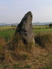
<< Our Photo Pages >> Menhir de la Peyrebiaire - Standing Stone (Menhir) in France in Auvergne:Haute-Loire (43)
Submitted by ocdolmen on Monday, 02 November 2009 Page Views: 3954
Neolithic and Bronze AgeSite Name: Menhir de la Peyrebiaire Alternative Name: Nolhac menhirCountry: France
NOTE: This site is 5.739 km away from the location you searched for.
Département: Auvergne:Haute-Loire (43) Type: Standing Stone (Menhir)
Nearest Town: Puy en Velay Nearest Village: Saint-Paulien
Latitude: 45.106884N Longitude: 3.825256E
Condition:
| 5 | Perfect |
| 4 | Almost Perfect |
| 3 | Reasonable but with some damage |
| 2 | Ruined but still recognisable as an ancient site |
| 1 | Pretty much destroyed, possibly visible as crop marks |
| 0 | No data. |
| -1 | Completely destroyed |
| 5 | Superb |
| 4 | Good |
| 3 | Ordinary |
| 2 | Not Good |
| 1 | Awful |
| 0 | No data. |
| 5 | Can be driven to, probably with disabled access |
| 4 | Short walk on a footpath |
| 3 | Requiring a bit more of a walk |
| 2 | A long walk |
| 1 | In the middle of nowhere, a nightmare to find |
| 0 | No data. |
| 5 | co-ordinates taken by GPS or official recorded co-ordinates |
| 4 | co-ordinates scaled from a detailed map |
| 3 | co-ordinates scaled from a bad map |
| 2 | co-ordinates of the nearest village |
| 1 | co-ordinates of the nearest town |
| 0 | no data |
Internal Links:
External Links:
")
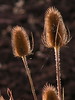
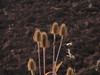
Nice 2 metre tall basalt monolith.
You may be viewing yesterday's version of this page. To see the most up to date information please register for a free account.
Do not use the above information on other web sites or publications without permission of the contributor.
davidmorgan has found this location on Google Street View:
Nearby Images from Flickr
The above images may not be of the site on this page, but were taken nearby. They are loaded from Flickr so please click on them for image credits.
Click here to see more info for this site
Nearby sites
Click here to view sites on an interactive map of the areaKey: Red: member's photo, Blue: 3rd party photo, Yellow: other image, Green: no photo - please go there and take one, Grey: site destroyed
Download sites to:
KML (Google Earth)
GPX (GPS waypoints)
CSV (Garmin/Navman)
CSV (Excel)
To unlock full downloads you need to sign up as a Contributory Member. Otherwise downloads are limited to 50 sites.
Turn off the page maps and other distractions
Nearby sites listing. In the following links * = Image available
7.5km ENE 75° Lou-Donat* Standing Stone (Menhir)
7.8km SE 145° Dolmen de Saint-Michel d'Aiguilhe* Burial Chamber or Dolmen
8.2km SE 146° La Pierre-des-Fievres* Burial Chamber or Dolmen
15.6km SSW 196° Dolmen de Séneujols* Burial Chamber or Dolmen
17.9km N 354° Pierre à Cupules de Chadoir Rock Art
18.2km NE 46° Artites Dolmen Burial Chamber or Dolmen
18.5km N 7° Pierre Plantée (Monteil)* Standing Stone (Menhir)
18.6km SSE 160° Dolmen de Collandre Burial Chamber or Dolmen
20.6km W 278° Tombe des Fées Dolmen* Burial Chamber or Dolmen
22.7km ESE 104° Pierre à Cupules de Monedeyre Rock Art
24.3km WNW 283° Marjallat Dolmen Burial Chamber or Dolmen
26.8km N 355° Dolmen des Fades* Burial Chamber or Dolmen
26.9km N 358° Pierre Plantée des Fades* Standing Stone (Menhir)
26.9km ENE 69° Roche à Cupules des Barris Standing Stones
27.6km N 358° Pierre des Soeurs Standing Stone (Menhir)
27.8km SSE 160° Camp Celtique d’Antoune Ancient Village or Settlement
28.7km W 279° Habitat préhistorique sous Abri du Blot Cave or Rock Shelter
29.0km ESE 102° Chièze Menhir* Standing Stone (Menhir)
29.5km E 93° Saint-Jeurés Menhir* Standing Stone (Menhir)
30.8km WSW 257° Dolmen de la Thuile aux Fées* Burial Chamber or Dolmen
31.6km NNW 349° Pierre Couverte (Chassouneyre) Burial Chamber or Dolmen
33.1km N 357° Triaille Dolmen Burial Chamber or Dolmen
33.9km E 98° Dolmen de Vacheresses Burial Chamber or Dolmen
34.4km WNW 297° Dolmen des Quatre Roches Burial Chamber or Dolmen
34.8km E 89° Croix-Menhir de Mendigoules* Standing Stone (Menhir)
View more nearby sites and additional images


 We would like to know more about this location. Please feel free to add a brief description and any relevant information in your own language.
 Wir möchten mehr über diese Stätte erfahren. Bitte zögern Sie nicht, eine kurze Beschreibung und relevante Informationen in Deutsch hinzuzufügen.
 Nous aimerions en savoir encore un peu sur les lieux. S'il vous plaît n'hesitez pas à ajouter une courte description et tous les renseignements pertinents dans votre propre langue.
 Quisieramos informarnos un poco más de las lugares. No dude en añadir una breve descripción y otros datos relevantes en su propio idioma.