

<< Our Photo Pages >> Dolmen de Taux - Burial Chamber or Dolmen in France in Picardie:Aisne (02)
Submitted by AlexHunger on Tuesday, 17 May 2005 Page Views: 3697
Neolithic and Bronze AgeSite Name: Dolmen de TauxCountry: France
NOTE: This site is 3.85 km away from the location you searched for.
Département: Picardie:Aisne (02) Type: Burial Chamber or Dolmen
Nearest Town: Soissons Nearest Village: Hartennes-et-Taux
Latitude: 49.287890N Longitude: 3.351410E
Condition:
| 5 | Perfect |
| 4 | Almost Perfect |
| 3 | Reasonable but with some damage |
| 2 | Ruined but still recognisable as an ancient site |
| 1 | Pretty much destroyed, possibly visible as crop marks |
| 0 | No data. |
| -1 | Completely destroyed |
| 5 | Superb |
| 4 | Good |
| 3 | Ordinary |
| 2 | Not Good |
| 1 | Awful |
| 0 | No data. |
| 5 | Can be driven to, probably with disabled access |
| 4 | Short walk on a footpath |
| 3 | Requiring a bit more of a walk |
| 2 | A long walk |
| 1 | In the middle of nowhere, a nightmare to find |
| 0 | No data. |
| 5 | co-ordinates taken by GPS or official recorded co-ordinates |
| 4 | co-ordinates scaled from a detailed map |
| 3 | co-ordinates scaled from a bad map |
| 2 | co-ordinates of the nearest village |
| 1 | co-ordinates of the nearest town |
| 0 | no data |
Internal Links:
External Links:
")
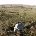
Large Dolmen, masoned rocks on sides
Location Source: T4T35.fr
You may be viewing yesterday's version of this page. To see the most up to date information please register for a free account.
Do not use the above information on other web sites or publications without permission of the contributor.
Nearby Images from Flickr
The above images may not be of the site on this page, but were taken nearby. They are loaded from Flickr so please click on them for image credits.
Click here to see more info for this site
Nearby sites
Click here to view sites on an interactive map of the areaKey: Red: member's photo, Blue: 3rd party photo, Yellow: other image, Green: no photo - please go there and take one, Grey: site destroyed
Download sites to:
KML (Google Earth)
GPX (GPS waypoints)
CSV (Garmin/Navman)
CSV (Excel)
To unlock full downloads you need to sign up as a Contributory Member. Otherwise downloads are limited to 50 sites.
Turn off the page maps and other distractions
Nearby sites listing. In the following links * = Image available
9.2km NE 52° Allée Couverte de la Forte-Terre Burial Chamber or Dolmen
9.3km ESE 105° Dolmen de la Butte de Housse Burial Chamber or Dolmen
12.6km SSW 207° Grotte Sépulcrale du Bouillon Cave or Rock Shelter
14.1km E 91° Banc des Trois-Seigneurs Rock Art
14.1km N 6° Pierre Frite de Crouy Natural Stone / Erratic / Other Natural Feature
14.8km WSW 254° Hypogée de la Pierre Fortière* Chambered Tomb
16.5km NNW 344° Dolmen dit la Pierre Laye* Burial Chamber or Dolmen
19.9km W 268° la Pierre Clouise* Polissoir
21.3km WSW 237° Menhir de Précy-à-Mont* Standing Stone (Menhir)
21.5km SE 128° Allée Couverte de Caranda* Burial Chamber or Dolmen
26.8km WNW 295° Cromlech du Parc-aux-Loups Stone Circle
28.4km N 355° Dolmen de Verneuil-sous-Coucy Burial Chamber or Dolmen
29.0km SSE 153° Pierre des Cosaques* Polissoir
30.6km W 262° Grotte Sepulcrale du Laris-Goguet Chambered Tomb
30.7km W 264° Grotte Sepulcrale de Lari-Baré Cave or Rock Shelter
32.3km ENE 70° Le Champ Tortu Burial Chamber or Dolmen
32.6km SW 215° Allée Couverte du Bois des Marêts Passage Grave
32.8km SW 215° Belleville Hypogee Ancient Village or Settlement
32.9km NW 323° Grès de Saint-Lucien Standing Stone (Menhir)
33.2km WNW 294° La Pierre Torniche* Burial Chamber or Dolmen
34.3km SW 217° Dolmen du Bois de Belleville Burial Chamber or Dolmen
35.6km NNW 331° Pierre de Saint-Hubert (B) Standing Stone (Menhir)
35.7km NNW 331° Pierre de Saint-Hubert (A) Standing Stone (Menhir)
35.9km W 271° Grotte du Mont-Megre Cave or Rock Shelter
36.1km W 265° Dolmen de Séry-Magneval Burial Chamber or Dolmen
View more nearby sites and additional images


 We would like to know more about this location. Please feel free to add a brief description and any relevant information in your own language.
 Wir möchten mehr über diese Stätte erfahren. Bitte zögern Sie nicht, eine kurze Beschreibung und relevante Informationen in Deutsch hinzuzufügen.
 Nous aimerions en savoir encore un peu sur les lieux. S'il vous plaît n'hesitez pas à ajouter une courte description et tous les renseignements pertinents dans votre propre langue.
 Quisieramos informarnos un poco más de las lugares. No dude en añadir una breve descripción y otros datos relevantes en su propio idioma.