

<< Our Photo Pages >> Menhir de Saint-Michel - Standing Stone (Menhir) in France in Languedoc:Hérault (34)
Submitted by regina on Wednesday, 10 February 2016 Page Views: 1302
Neolithic and Bronze AgeSite Name: Menhir de Saint-MichelCountry: France
NOTE: This site is 0.308 km away from the location you searched for.
Département: Languedoc:Hérault (34) Type: Standing Stone (Menhir)
Nearest Town: Lodève Nearest Village: Saint-Michel
Latitude: 43.855180N Longitude: 3.390470E
Condition:
| 5 | Perfect |
| 4 | Almost Perfect |
| 3 | Reasonable but with some damage |
| 2 | Ruined but still recognisable as an ancient site |
| 1 | Pretty much destroyed, possibly visible as crop marks |
| 0 | No data. |
| -1 | Completely destroyed |
| 5 | Superb |
| 4 | Good |
| 3 | Ordinary |
| 2 | Not Good |
| 1 | Awful |
| 0 | No data. |
| 5 | Can be driven to, probably with disabled access |
| 4 | Short walk on a footpath |
| 3 | Requiring a bit more of a walk |
| 2 | A long walk |
| 1 | In the middle of nowhere, a nightmare to find |
| 0 | No data. |
| 5 | co-ordinates taken by GPS or official recorded co-ordinates |
| 4 | co-ordinates scaled from a detailed map |
| 3 | co-ordinates scaled from a bad map |
| 2 | co-ordinates of the nearest village |
| 1 | co-ordinates of the nearest town |
| 0 | no data |
Internal Links:
External Links:
I have visited· I would like to visit
regina has visited here
")
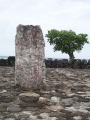
The menhir is about 2 m. long, but covered with stones.
You may be viewing yesterday's version of this page. To see the most up to date information please register for a free account.
Do not use the above information on other web sites or publications without permission of the contributor.
Nearby Images from Flickr
The above images may not be of the site on this page, but were taken nearby. They are loaded from Flickr so please click on them for image credits.
Click here to see more info for this site
Nearby sites
Click here to view sites on an interactive map of the areaKey: Red: member's photo, Blue: 3rd party photo, Yellow: other image, Green: no photo - please go there and take one, Grey: site destroyed
Download sites to:
KML (Google Earth)
GPX (GPS waypoints)
CSV (Garmin/Navman)
CSV (Excel)
To unlock full downloads you need to sign up as a Contributory Member. Otherwise downloads are limited to 50 sites.
Turn off the page maps and other distractions
Nearby sites listing. In the following links * = Image available
776m WNW 286° Menhir de la Bergerie de l'Hôpital* Standing Stone (Menhir)
1.1km NNW 338° Menhir de Rajolas 3* Standing Stone (Menhir)
1.2km NNW 327° Menhir de Rajolas 2* Standing Stone (Menhir)
1.4km SSE 163° Menhir des Rastelenques* Standing Stone (Menhir)
1.4km NNW 335° Menhir de Rajolas 1* Standing Stone (Menhir)
1.4km WSW 241° Dolmen Saut du Lièvre 3* Burial Chamber or Dolmen
1.5km E 83° Dolmen des Peyrières* Burial Chamber or Dolmen
1.5km SW 232° Dolmen Saut du Lièvre 5* Chambered Cairn
1.6km SW 233° Dolmen Saut du Lièvre 4* Burial Chamber or Dolmen
1.8km S 184° Menhir de Cour Lavagnes* Standing Stone (Menhir)
1.8km S 184° Menhir Cour Lavagnes 2* Standing Stones
1.8km S 184° Tumuli de Cours Lavagnès (3)* Round Barrow(s)
1.8km WSW 246° Puech Fulcran Dolmen* Burial Chamber or Dolmen
1.9km WSW 244° Menhir Saut du Lièvre* Standing Stone (Menhir)
2.1km SSW 195° Menhir Les Plos* Standing Stone (Menhir)
2.1km WNW 281° Menhir de Combe Rouge* Standing Stone (Menhir)
2.3km NNE 12° Dolmen des Buissières 5* Burial Chamber or Dolmen
2.4km ENE 77° Groupe de Menhirs Gamboules* Standing Stones
2.4km N 0° Menhir des Buissières* Standing Stone (Menhir)
2.4km N 3° Dolmens des Buissières 1-4* Burial Chamber or Dolmen
2.5km ENE 68° Menhir 4 Gamboules* Standing Stone (Menhir)
2.6km NW 304° Le Cros menhir Standing Stone (Menhir)
2.6km E 87° Menhir de St. Geniez* Standing Stone (Menhir)
2.7km NNE 25° Dolmen de Latude 6* Burial Chamber or Dolmen
2.9km SSW 203° Les Barasques Menhirs* Standing Stone (Menhir)
View more nearby sites and additional images


 We would like to know more about this location. Please feel free to add a brief description and any relevant information in your own language.
 Wir möchten mehr über diese Stätte erfahren. Bitte zögern Sie nicht, eine kurze Beschreibung und relevante Informationen in Deutsch hinzuzufügen.
 Nous aimerions en savoir encore un peu sur les lieux. S'il vous plaît n'hesitez pas à ajouter une courte description et tous les renseignements pertinents dans votre propre langue.
 Quisieramos informarnos un poco más de las lugares. No dude en añadir una breve descripción y otros datos relevantes en su propio idioma.