


<< Our Photo Pages >> Boezinge - Modern Stone Circle etc in Belgium in Oost-Vlaanderen
Submitted by thecaptain on Thursday, 14 August 2014 Page Views: 13771
Modern SitesSite Name: BoezingeCountry: Belgium
NOTE: This site is 22.085 km away from the location you searched for.
Province: Oost-Vlaanderen Type: Modern Stone Circle etc
Nearest Town: Ieper Nearest Village: Boezinge
Latitude: 50.897310N Longitude: 2.874160E
Condition:
| 5 | Perfect |
| 4 | Almost Perfect |
| 3 | Reasonable but with some damage |
| 2 | Ruined but still recognisable as an ancient site |
| 1 | Pretty much destroyed, possibly visible as crop marks |
| 0 | No data. |
| -1 | Completely destroyed |
| 5 | Superb |
| 4 | Good |
| 3 | Ordinary |
| 2 | Not Good |
| 1 | Awful |
| 0 | No data. |
| 5 | Can be driven to, probably with disabled access |
| 4 | Short walk on a footpath |
| 3 | Requiring a bit more of a walk |
| 2 | A long walk |
| 1 | In the middle of nowhere, a nightmare to find |
| 0 | No data. |
| 5 | co-ordinates taken by GPS or official recorded co-ordinates |
| 4 | co-ordinates scaled from a detailed map |
| 3 | co-ordinates scaled from a bad map |
| 2 | co-ordinates of the nearest village |
| 1 | co-ordinates of the nearest town |
| 0 | no data |
Internal Links:
External Links:
I have visited· I would like to visit
maByr has visited here
")
Update by Alta-Falisa, 13 August 2014.
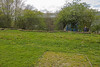
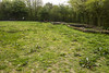
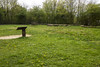
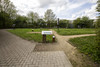
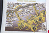
In 1927, the town of Plourgat (Brittany) presented a 16th century Calvary, which was erected in the village of Boezinge, in the midst of this WWI-battelfield.
A survivor of this first gas attack, J.B.Lebret, presented the stones, taken from a megalith at Hénanbihen (see photo of the original monument), to reconstruct a dolmen.
Source : "De Inventaris van het Wereldoorlogerfgoed".
You may be viewing yesterday's version of this page. To see the most up to date information please register for a free account.
")
")
")
Do not use the above information on other web sites or publications without permission of the contributor.
Nearby Images from Flickr
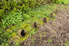
The above images may not be of the site on this page, but were taken nearby. They are loaded from Flickr so please click on them for image credits.
Click here to see more info for this site
Nearby sites
Click here to view sites on an interactive map of the areaKey: Red: member's photo, Blue: 3rd party photo, Yellow: other image, Green: no photo - please go there and take one, Grey: site destroyed
Download sites to:
KML (Google Earth)
GPX (GPS waypoints)
CSV (Garmin/Navman)
CSV (Excel)
To unlock full downloads you need to sign up as a Contributory Member. Otherwise downloads are limited to 50 sites.
Turn off the page maps and other distractions
Nearby sites listing. In the following links * = Image available
10.1km ESE 120° Porch am Tir Nan Myfyr* Stone Circle
16.7km SW 218° Petit Janne de Yourcenar* Standing Stone (Menhir)
20.1km SSW 211° La Pierre-qui-Tourne de Bailleul Standing Stone (Menhir)
39.8km SSE 147° Mont des Tombes Hillfort
46.1km ESE 109° Peetje en Meetje * Burial Chamber or Dolmen
47.0km ESE 109° Kluisberg* Natural Stone / Erratic / Other Natural Feature
48.0km S 179° Tombe de Pont-a-Vendin Burial Chamber or Dolmen
48.1km SE 132° Musée archéologique de Tournai* Museum
53.6km ESE 106° Menhir van Jolybos* Modern Stone Circle etc
53.6km ESE 106° Dolmen van Jolybos* Modern Stone Circle etc
55.0km SE 131° Tumulus du Trou de Billemont* Artificial Mound
56.2km SE 137° Brunehault* Standing Stone (Menhir)
56.7km SSW 200° Dolmen dit la Table des Fées* Burial Chamber or Dolmen
57.2km SSE 162° Douai Musée d'Archéologie* Museum
57.5km SSW 201° Le Gal de Gauchin* Standing Stone (Menhir)
62.7km SSW 193° Les Pierres Jumelles (Mont-Saint-Éloi)* Standing Stones
63.6km E 91° Provincial Archeological Museum* Museum
66.7km ESE 122° Archéosite* Museum
68.5km SSE 162° Menhir dit la Borne-Grand-Père* Marker Stone
69.3km S 174° Cromlech dit Les-Sept-Bonnettes* Stone Circle
69.4km S 169° Dolmen dit les Pierres Chavattes* Burial Chamber or Dolmen
70.6km S 171° La Pierre du Diable (Lécluse)* Standing Stone (Menhir)
71.5km SE 130° Bernissart, Jardin Géologique* Museum
71.8km SSE 167° Palluel Menhir Statue* Standing Stone (Menhir)
71.8km ENE 67° Penitentiesteen van H. Bavo* Early Christian Sculptured Stone
View more nearby sites and additional images


 We would like to know more about this location. Please feel free to add a brief description and any relevant information in your own language.
 Wir möchten mehr über diese Stätte erfahren. Bitte zögern Sie nicht, eine kurze Beschreibung und relevante Informationen in Deutsch hinzuzufügen.
 Nous aimerions en savoir encore un peu sur les lieux. S'il vous plaît n'hesitez pas à ajouter une courte description et tous les renseignements pertinents dans votre propre langue.
 Quisieramos informarnos un poco más de las lugares. No dude en añadir una breve descripción y otros datos relevantes en su propio idioma.