


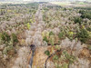
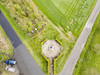
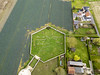
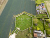
<< Other Photo Pages >> Porch am Tir Nan Myfyr - Stone Circle in Belgium in West-Vlaanderen
Submitted by maByr on Wednesday, 26 July 2017 Page Views: 2141
Neolithic and Bronze AgeSite Name: Porch am Tir Nan Myfyr Alternative Name: Land of Neverending Mind, Steencirkel BeselareCountry: Belgium
NOTE: This site is 23.736 km away from the location you searched for.
Province: West-Vlaanderen Type: Stone Circle
Nearest Town: Kortrijk Nearest Village: Beselare
Latitude: 50.852200N Longitude: 2.999500E
Condition:
| 5 | Perfect |
| 4 | Almost Perfect |
| 3 | Reasonable but with some damage |
| 2 | Ruined but still recognisable as an ancient site |
| 1 | Pretty much destroyed, possibly visible as crop marks |
| 0 | No data. |
| -1 | Completely destroyed |
| 5 | Superb |
| 4 | Good |
| 3 | Ordinary |
| 2 | Not Good |
| 1 | Awful |
| 0 | No data. |
| 5 | Can be driven to, probably with disabled access |
| 4 | Short walk on a footpath |
| 3 | Requiring a bit more of a walk |
| 2 | A long walk |
| 1 | In the middle of nowhere, a nightmare to find |
| 0 | No data. |
| 5 | co-ordinates taken by GPS or official recorded co-ordinates |
| 4 | co-ordinates scaled from a detailed map |
| 3 | co-ordinates scaled from a bad map |
| 2 | co-ordinates of the nearest village |
| 1 | co-ordinates of the nearest town |
| 0 | no data |
Internal Links:
External Links:
I have visited· I would like to visit
maByr visited - their rating: Cond: 5 Amb: 5 Access: 3
")
Source of phots and more information : tirnanog
You may be viewing yesterday's version of this page. To see the most up to date information please register for a free account.
")
Do not use the above information on other web sites or publications without permission of the contributor.
Nearby Images from Flickr
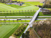
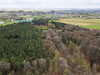
The above images may not be of the site on this page, but were taken nearby. They are loaded from Flickr so please click on them for image credits.
Click here to see more info for this site
Nearby sites
Click here to view sites on an interactive map of the areaKey: Red: member's photo, Blue: 3rd party photo, Yellow: other image, Green: no photo - please go there and take one, Grey: site destroyed
Download sites to:
KML (Google Earth)
GPX (GPS waypoints)
CSV (Garmin/Navman)
CSV (Excel)
To unlock full downloads you need to sign up as a Contributory Member. Otherwise downloads are limited to 50 sites.
Turn off the page maps and other distractions
Nearby sites listing. In the following links * = Image available
10.1km WNW 300° Boezinge* Modern Stone Circle etc
20.8km WSW 247° Petit Janne de Yourcenar* Standing Stone (Menhir)
22.8km WSW 238° La Pierre-qui-Tourne de Bailleul Standing Stone (Menhir)
31.2km SSE 156° Mont des Tombes Hillfort
36.2km ESE 106° Peetje en Meetje * Burial Chamber or Dolmen
37.1km ESE 106° Kluisberg* Natural Stone / Erratic / Other Natural Feature
38.3km SE 135° Musée archéologique de Tournai* Museum
43.7km S 191° Tombe de Pont-a-Vendin Burial Chamber or Dolmen
43.9km ESE 103° Menhir van Jolybos* Modern Stone Circle etc
43.9km ESE 103° Dolmen van Jolybos* Modern Stone Circle etc
45.1km SE 134° Tumulus du Trou de Billemont* Artificial Mound
46.6km SE 141° Brunehault* Standing Stone (Menhir)
50.1km S 169° Douai Musée d'Archéologie* Museum
54.9km E 86° Provincial Archeological Museum* Museum
55.8km SSW 210° Dolmen dit la Table des Fées* Burial Chamber or Dolmen
56.6km ESE 123° Archéosite* Museum
56.9km SSW 211° Le Gal de Gauchin* Standing Stone (Menhir)
60.6km SSW 202° Les Pierres Jumelles (Mont-Saint-Éloi)* Standing Stones
61.4km SSE 169° Menhir dit la Borne-Grand-Père* Marker Stone
61.6km SE 132° Bernissart, Jardin Géologique* Museum
63.3km S 176° Dolmen dit les Pierres Chavattes* Burial Chamber or Dolmen
64.0km S 182° Cromlech dit Les-Sept-Bonnettes* Stone Circle
64.8km S 178° La Pierre du Diable (Lécluse)* Standing Stone (Menhir)
65.4km S 174° Palluel Menhir Statue* Standing Stone (Menhir)
65.9km S 171° La-Pierre-qui-Pousse (Aubigny-au-Bac)* Standing Stone (Menhir)
View more nearby sites and additional images


 We would like to know more about this location. Please feel free to add a brief description and any relevant information in your own language.
 Wir möchten mehr über diese Stätte erfahren. Bitte zögern Sie nicht, eine kurze Beschreibung und relevante Informationen in Deutsch hinzuzufügen.
 Nous aimerions en savoir encore un peu sur les lieux. S'il vous plaît n'hesitez pas à ajouter une courte description et tous les renseignements pertinents dans votre propre langue.
 Quisieramos informarnos un poco más de las lugares. No dude en añadir una breve descripción y otros datos relevantes en su propio idioma.