 with our Megalithic Portal iPhone app")

<< Text Pages >> Telandros - Ancient Village or Settlement in Turkey
Submitted by SolarMegalith on Thursday, 19 July 2012 Page Views: 3657
Multi-periodSite Name: Telandros Alternative Name: TelandrusCountry: Turkey
NOTE: This site is 11.849 km away from the location you searched for.
Type: Ancient Village or Settlement
Latitude: 36.674524N Longitude: 28.915857E
Condition:
| 5 | Perfect |
| 4 | Almost Perfect |
| 3 | Reasonable but with some damage |
| 2 | Ruined but still recognisable as an ancient site |
| 1 | Pretty much destroyed, possibly visible as crop marks |
| 0 | No data. |
| -1 | Completely destroyed |
| 5 | Superb |
| 4 | Good |
| 3 | Ordinary |
| 2 | Not Good |
| 1 | Awful |
| 0 | No data. |
| 5 | Can be driven to, probably with disabled access |
| 4 | Short walk on a footpath |
| 3 | Requiring a bit more of a walk |
| 2 | A long walk |
| 1 | In the middle of nowhere, a nightmare to find |
| 0 | No data. |
| 5 | co-ordinates taken by GPS or official recorded co-ordinates |
| 4 | co-ordinates scaled from a detailed map |
| 3 | co-ordinates scaled from a bad map |
| 2 | co-ordinates of the nearest village |
| 1 | co-ordinates of the nearest town |
| 0 | no data |
Internal Links:
External Links:
Ancient Lycian City in Muğla Province, Turkey
Ruins of an ancient Lycian city with remains of a temple and necropolis.
You may be viewing yesterday's version of this page. To see the most up to date information please register for a free account.
Do not use the above information on other web sites or publications without permission of the contributor.
Nearby Images from Flickr

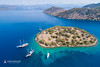
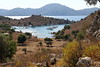
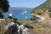

The above images may not be of the site on this page, but were taken nearby. They are loaded from Flickr so please click on them for image credits.
Click here to see more info for this site
Nearby sites
Click here to view sites on an interactive map of the areaKey: Red: member's photo, Blue: 3rd party photo, Yellow: other image, Green: no photo - please go there and take one, Grey: site destroyed
Download sites to:
KML (Google Earth)
GPX (GPS waypoints)
CSV (Garmin/Navman)
CSV (Excel)
To unlock full downloads you need to sign up as a Contributory Member. Otherwise downloads are limited to 50 sites.
Turn off the page maps and other distractions
Nearby sites listing. In the following links * = Image available
7.7km SW 221° Lydae* Ancient Village or Settlement
18.8km ESE 108° Fethiye Museum Museum
19.1km ESE 109° Telmessos* Ancient Village or Settlement
28.4km E 81° Cadianda* Ancient Village or Settlement
31.1km WNW 303° Kaunos* Ancient Village or Settlement
36.7km SE 124° Pinara* Ancient Village or Settlement
38.6km SE 140° Sidyma* Ancient Village or Settlement
41.1km E 79° Araxa (Lycia)* Rock Cut Tomb
46.9km ESE 106° Tlos Settlement* Ancient Village or Settlement
47.3km SE 143° Pydnai* Ancient Village or Settlement
50.5km SE 134° Xanthos* Ancient Village or Settlement
50.7km SE 139° Letoon* Ancient Village or Settlement
54.7km NE 53° Boubon Ancient Village or Settlement
57.5km E 95° Kastabara* Ancient Village or Settlement
58.2km SE 142° Patara* Ancient Village or Settlement
58.4km ENE 75° Oinoanda* Ancient Village or Settlement
58.6km W 279° Amos (Caria) Ancient Village or Settlement
66.5km WSW 248° Rhodos Temple of Aphrodite Ancient Temple
67.0km ENE 62° Balboura* Ancient Village or Settlement
67.8km WSW 248° Nymfaia Rodos* Ancient Temple
67.8km WSW 247° Ferenikis Park* Chambered Tomb
67.9km WSW 248° Temple of Zeus Polieos and Athina Polias* Ancient Temple
68.2km WSW 248° Rhodos Temple of Apollo* Ancient Temple
68.6km W 280° Kastabos Temple of Hemithea Ancient Temple
73.3km SE 131° Gökçeören* Rock Cut Tomb
View more nearby sites and additional images


 We would like to know more about this location. Please feel free to add a brief description and any relevant information in your own language.
 Wir möchten mehr über diese Stätte erfahren. Bitte zögern Sie nicht, eine kurze Beschreibung und relevante Informationen in Deutsch hinzuzufügen.
 Nous aimerions en savoir encore un peu sur les lieux. S'il vous plaît n'hesitez pas à ajouter une courte description et tous les renseignements pertinents dans votre propre langue.
 Quisieramos informarnos un poco más de las lugares. No dude en añadir una breve descripción y otros datos relevantes en su propio idioma.