


<< Text Pages >> Deir el-Hagar Temple - Ancient Temple in Egypt in Nubia
Submitted by AlexHunger on Friday, 07 November 2008 Page Views: 4177
Roman, Greek and ClassicalSite Name: Deir el-Hagar TempleCountry: Egypt
NOTE: This site is 97.416 km away from the location you searched for.
Region: Nubia Type: Ancient Temple
Nearest Town: Dakhla Oasis Nearest Village: Dachla Oasis
Latitude: 25.665095N Longitude: 28.813215E
Condition:
| 5 | Perfect |
| 4 | Almost Perfect |
| 3 | Reasonable but with some damage |
| 2 | Ruined but still recognisable as an ancient site |
| 1 | Pretty much destroyed, possibly visible as crop marks |
| 0 | No data. |
| -1 | Completely destroyed |
| 5 | Superb |
| 4 | Good |
| 3 | Ordinary |
| 2 | Not Good |
| 1 | Awful |
| 0 | No data. |
| 5 | Can be driven to, probably with disabled access |
| 4 | Short walk on a footpath |
| 3 | Requiring a bit more of a walk |
| 2 | A long walk |
| 1 | In the middle of nowhere, a nightmare to find |
| 0 | No data. |
| 5 | co-ordinates taken by GPS or official recorded co-ordinates |
| 4 | co-ordinates scaled from a detailed map |
| 3 | co-ordinates scaled from a bad map |
| 2 | co-ordinates of the nearest village |
| 1 | co-ordinates of the nearest town |
| 0 | no data |
Internal Links:
External Links:
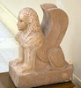
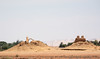
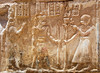
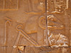
Ancient Temple in the western Desert of Egypt
Ancient temple of Amon-Ra , Mut and Kondschu in the western desert of Egypt, probably on old caravan route.
Discovered by German explorer Gerhard Rohlfs in 1874
You may be viewing yesterday's version of this page. To see the most up to date information please register for a free account.
Do not use the above information on other web sites or publications without permission of the contributor.
Nearby Images from Flickr


The above images may not be of the site on this page, but were taken nearby. They are loaded from Flickr so please click on them for image credits.
Click here to see more info for this site
Nearby sites
Click here to view sites on an interactive map of the areaKey: Red: member's photo, Blue: 3rd party photo, Yellow: other image, Green: no photo - please go there and take one, Grey: site destroyed
Download sites to:
KML (Google Earth)
GPX (GPS waypoints)
CSV (Garmin/Navman)
CSV (Excel)
To unlock full downloads you need to sign up as a Contributory Member. Otherwise downloads are limited to 50 sites.
Turn off the page maps and other distractions
Nearby sites listing. In the following links * = Image available
174.9km E 98° Umm El-Mawagir Ancient Village or Settlement
189.6km NNW 341° White Desert (Farafra)* Natural Stone / Erratic / Other Natural Feature
218.6km NNW 327° Farafra Oasis* Rock Art
284.0km NE 55° Khnum-Nakht and Nekht-Ankh Tomb Rock Cut Tomb
288.8km NE 54° Asyut Ancient Village or Settlement
298.4km N 1° Bahariya Museum of the Golden Mummies* Museum
298.8km N 1° Qaret Qasr es Salim Tombs* Rock Cut Tomb
299.4km N 1° Ain el-Mouftella Temple of Amun* Ancient Temple
299.4km ENE 57° Tjebu tombs Barrow Cemetery
301.7km ENE 61° El-Hammamiya Tombs Rock Cut Tomb
301.9km ENE 62° Tjebu Governor Tombs Rock Cut Tomb
302.5km ENE 62° Tjebu Temple Ancient Temple
302.8km ENE 76° Sanakht's Mastaba Pyramid / Mastaba
303.9km ENE 76° Djoser Netjerikhef Mastaba Pyramid / Mastaba
304.7km NE 43° Al Amarna* Ancient Palace
307.4km NE 40° Hermopolis Temple of Thoth* Ancient Temple
314.9km ENE 79° Shunet ez Zebib* Ancient Temple
315.7km ENE 79° Abydos Temple of Ramses II Ancient Temple
315.9km E 79° Osirieon* Ancient Temple
316.0km E 79° Abydos Temple of Seti I* Ancient Temple
316.3km E 79° Abydos Senusret III Funerary Complex Rock Cut Tomb
317.6km E 79° Pyramid of Ahmose Pyramid / Mastaba
318.0km ENE 75° Naga el-Deir Necropolis Barrow Cemetery
320.1km E 79° Sinki Pyramid Pyramid / Mastaba
331.7km NE 37° Zawyet el-Amwat Pyramid Pyramid / Mastaba
View more nearby sites and additional images


 We would like to know more about this location. Please feel free to add a brief description and any relevant information in your own language.
 Wir möchten mehr über diese Stätte erfahren. Bitte zögern Sie nicht, eine kurze Beschreibung und relevante Informationen in Deutsch hinzuzufügen.
 Nous aimerions en savoir encore un peu sur les lieux. S'il vous plaît n'hesitez pas à ajouter une courte description et tous les renseignements pertinents dans votre propre langue.
 Quisieramos informarnos un poco más de las lugares. No dude en añadir una breve descripción y otros datos relevantes en su propio idioma.