 with our Megalithic Portal iPhone app")


<< Our Photo Pages >> Tropaeum Traiani - Sculptured Stone in Romania
Submitted by mfrincu on Saturday, 22 August 2015 Page Views: 1616
Multi-periodSite Name: Tropaeum Traiani Alternative Name: Tropheum TraianiCountry: Romania
NOTE: This site is 4.442 km away from the location you searched for.
Type: Sculptured Stone
Nearest Town: Constanta Nearest Village: Adamclisi
Latitude: 44.102000N Longitude: 27.955000E
Condition:
| 5 | Perfect |
| 4 | Almost Perfect |
| 3 | Reasonable but with some damage |
| 2 | Ruined but still recognisable as an ancient site |
| 1 | Pretty much destroyed, possibly visible as crop marks |
| 0 | No data. |
| -1 | Completely destroyed |
| 5 | Superb |
| 4 | Good |
| 3 | Ordinary |
| 2 | Not Good |
| 1 | Awful |
| 0 | No data. |
| 5 | Can be driven to, probably with disabled access |
| 4 | Short walk on a footpath |
| 3 | Requiring a bit more of a walk |
| 2 | A long walk |
| 1 | In the middle of nowhere, a nightmare to find |
| 0 | No data. |
| 5 | co-ordinates taken by GPS or official recorded co-ordinates |
| 4 | co-ordinates scaled from a detailed map |
| 3 | co-ordinates scaled from a bad map |
| 2 | co-ordinates of the nearest village |
| 1 | co-ordinates of the nearest town |
| 0 | no data |
Internal Links:
External Links:
")
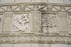
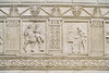
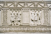
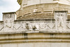
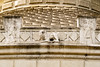
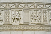
The monument was built between 106-109 to comemorate the battle of Adamclisi faught in the winter of 101 A.D. against an alliance of Dacian, Germanic and Sarmatian tribes. Almost 4000 legionaries died in the battle. The current monument is an exact replica of the original and was built between 1974-1977. 80 percent of the original site can be found in the Adamclisi museum. Nearby, a Roman earth mound containing the remains of an important Roman officer can be seen as well.
You may be viewing yesterday's version of this page. To see the most up to date information please register for a free account.
Do not use the above information on other web sites or publications without permission of the contributor.
Nearby Images from Flickr
The above images may not be of the site on this page, but were taken nearby. They are loaded from Flickr so please click on them for image credits.
Click here to see more info for this site
Nearby sites
Click here to view sites on an interactive map of the areaKey: Red: member's photo, Blue: 3rd party photo, Yellow: other image, Green: no photo - please go there and take one, Grey: site destroyed
Download sites to:
KML (Google Earth)
GPX (GPS waypoints)
CSV (Garmin/Navman)
CSV (Excel)
To unlock full downloads you need to sign up as a Contributory Member. Otherwise downloads are limited to 50 sites.
Turn off the page maps and other distractions
Nearby sites listing. In the following links * = Image available
1.9km S 187° Adamclisi Museum of Antiquities* Museum
44.9km NNE 14° Capidava* Ancient Village or Settlement
56.7km E 82° Constanta Museum of National History and Archaeology* Museum
59.4km ESE 122° Callatis* Ancient Village or Settlement
59.5km ESE 122° Callatis Museum of Archaeology Museum
79.3km SSE 167° Cybele Temple* Ancient Temple
81.5km NE 52° Histria Museum of History* Museum
81.9km NE 52° Histria* Ancient Village or Settlement
82.5km NE 50° Istria burial site* Barrow Cemetery
86.0km NE 52° Fertility menhir* Standing Stone (Menhir)
99.4km SSW 192° Pobiti Kamani* Natural Stone / Erratic / Other Natural Feature
99.5km S 182° Varna Museum of Archaeology Museum
103.1km WSW 248° Sveshtari Thracian Tomb* Chambered Cairn
103.4km SW 220° Pliska Mound Artificial Mound
106.8km SW 219° Pliska Menhirs* Standing Stones
107.0km NE 47° Argamum* Ancient Village or Settlement
115.0km SSW 200° Solnitsata* Ancient Village or Settlement
124.7km NNE 22° Telita-Celic Dere* Barrow Cemetery
138.9km WNW 285° Cernica Neolithic Tombs* Barrow Cemetery
152.4km WNW 285° National Museum of Romanian History Museum
161.5km S 187° Nesebar Necropolis* Burial Chamber or Dolmen
189.4km NW 322° Turtudui menhir* Standing Stone (Menhir)
189.5km NW 321° Menhir near Fundul Pesterii* Standing Stone (Menhir)
189.5km NW 321° Fundul Pesterii Cave* Rock Art
199.7km S 184° Beglik Tash* Natural Stone / Erratic / Other Natural Feature
View more nearby sites and additional images


 We would like to know more about this location. Please feel free to add a brief description and any relevant information in your own language.
 Wir möchten mehr über diese Stätte erfahren. Bitte zögern Sie nicht, eine kurze Beschreibung und relevante Informationen in Deutsch hinzuzufügen.
 Nous aimerions en savoir encore un peu sur les lieux. S'il vous plaît n'hesitez pas à ajouter une courte description et tous les renseignements pertinents dans votre propre langue.
 Quisieramos informarnos un poco más de las lugares. No dude en añadir una breve descripción y otros datos relevantes en su propio idioma.