


<< Other Photo Pages >> Cabyle - Ancient Village or Settlement in Bulgaria
Submitted by AlexHunger on Saturday, 05 August 2006 Page Views: 6027
Multi-periodSite Name: Cabyle Alternative Name: KabileCountry: Bulgaria
NOTE: This site is 7.35 km away from the location you searched for.
Type: Ancient Village or Settlement
Nearest Town: Yambol Nearest Village: Kabile
Latitude: 42.549350N Longitude: 26.484128E
Condition:
| 5 | Perfect |
| 4 | Almost Perfect |
| 3 | Reasonable but with some damage |
| 2 | Ruined but still recognisable as an ancient site |
| 1 | Pretty much destroyed, possibly visible as crop marks |
| 0 | No data. |
| -1 | Completely destroyed |
| 5 | Superb |
| 4 | Good |
| 3 | Ordinary |
| 2 | Not Good |
| 1 | Awful |
| 0 | No data. |
| 5 | Can be driven to, probably with disabled access |
| 4 | Short walk on a footpath |
| 3 | Requiring a bit more of a walk |
| 2 | A long walk |
| 1 | In the middle of nowhere, a nightmare to find |
| 0 | No data. |
| 5 | co-ordinates taken by GPS or official recorded co-ordinates |
| 4 | co-ordinates scaled from a detailed map |
| 3 | co-ordinates scaled from a bad map |
| 2 | co-ordinates of the nearest village |
| 1 | co-ordinates of the nearest town |
| 0 | no data |
Internal Links:
External Links:
Ancient Village or Settlement in Bulgaria
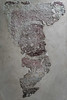
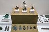
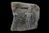
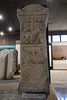
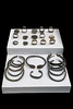
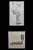
The Thracian royal city of Cabyle is located on a plateau and is crowned with a stone acropolis. It was inhabited between 2000 BCE and 700 CE, becoming a Roman outpost at the end of the 1st century CE. Part of the Kabile National Archaeology Reserve
You may be viewing yesterday's version of this page. To see the most up to date information please register for a free account.
Do not use the above information on other web sites or publications without permission of the contributor.
davidmorgan has found this location on Google Street View:
Nearby Images from Flickr
The above images may not be of the site on this page, but were taken nearby. They are loaded from Flickr so please click on them for image credits.
Click here to see more info for this site
Nearby sites
Click here to view sites on an interactive map of the areaKey: Red: member's photo, Blue: 3rd party photo, Yellow: other image, Green: no photo - please go there and take one, Grey: site destroyed
Download sites to:
KML (Google Earth)
GPX (GPS waypoints)
CSV (Garmin/Navman)
CSV (Excel)
To unlock full downloads you need to sign up as a Contributory Member. Otherwise downloads are limited to 50 sites.
Turn off the page maps and other distractions
Nearby sites listing. In the following links * = Image available
31.6km SSE 162° Baalar Kayryak Artificial Mound
59.2km SSW 201° Balgarska Poliana Dolmen* Chambered Tomb
59.4km SSW 200° Gaidarov Dolap dolmen Chambered Tomb
72.0km SW 214° Chuchul Kamak Standing Stone (Menhir)
72.4km SE 130° The Big Stone Natural Stone / Erratic / Other Natural Feature
72.7km W 259° Stara Zagora Neolithic dwellings* Ancient Village or Settlement
74.3km SSW 205° Mound near Izvorovo* Round Barrow(s)
74.9km ESE 121° Dolmen Ashlamata* Passage Grave
75.2km SE 131° Dolmen Belevren 3* Burial Chamber or Dolmen
75.4km SE 130° Dolmen Belevren 4* Burial Chamber or Dolmen
75.9km SSE 156° Vaysal Dolmen* Burial Chamber or Dolmen
76.1km SE 131° Dolmen Belevren 1* Burial Chamber or Dolmen
76.4km SE 131° Dolmen Belevren 2* Burial Chamber or Dolmen
76.9km SSE 161° Standing Stones of Türbe Standing Stones
77.3km SSE 158° Kircesme Multiple Stone Rows Multiple Stone Rows / Avenue
77.4km SSE 160° Hacidanisment Menhir* Standing Stone (Menhir)
77.4km SSW 201° Eshmedzhika Dolmen Burial Chamber or Dolmen
79.2km SSE 153° Berberoglu Ayazmasi Standing Stones
80.6km SSE 164° Dolmen North Lalapasa* Burial Chamber or Dolmen
81.8km SSE 165° Lalapasa Dolmen* Burial Chamber or Dolmen
83.3km S 171° Kirikkoy Stones Stone Circle
89.2km W 276° Kazanlak Tholos Chambered Cairn
89.5km W 275° Kazanlak Museum of History Museum
89.6km SW 215° Ostur kamuk Dolmen Burial Chamber or Dolmen
90.7km W 272° Buzovgrad Megalith* Burial Chamber or Dolmen
View more nearby sites and additional images


 We would like to know more about this location. Please feel free to add a brief description and any relevant information in your own language.
 Wir möchten mehr über diese Stätte erfahren. Bitte zögern Sie nicht, eine kurze Beschreibung und relevante Informationen in Deutsch hinzuzufügen.
 Nous aimerions en savoir encore un peu sur les lieux. S'il vous plaît n'hesitez pas à ajouter une courte description et tous les renseignements pertinents dans votre propre langue.
 Quisieramos informarnos un poco más de las lugares. No dude en añadir una breve descripción y otros datos relevantes en su propio idioma.