

<< Text Pages >> Sarafova mound - Chambered Tomb in Bulgaria
Submitted by davidmorgan on Thursday, 06 August 2015 Page Views: 1283
Neolithic and Bronze AgeSite Name: Sarafova moundCountry: Bulgaria
NOTE: This site is 26.957 km away from the location you searched for.
Type: Chambered Tomb
Nearest Town: Kazanlak Nearest Village: Kran
Latitude: 42.675688N Longitude: 25.381448E
Condition:
| 5 | Perfect |
| 4 | Almost Perfect |
| 3 | Reasonable but with some damage |
| 2 | Ruined but still recognisable as an ancient site |
| 1 | Pretty much destroyed, possibly visible as crop marks |
| 0 | No data. |
| -1 | Completely destroyed |
| 5 | Superb |
| 4 | Good |
| 3 | Ordinary |
| 2 | Not Good |
| 1 | Awful |
| 0 | No data. |
| 5 | Can be driven to, probably with disabled access |
| 4 | Short walk on a footpath |
| 3 | Requiring a bit more of a walk |
| 2 | A long walk |
| 1 | In the middle of nowhere, a nightmare to find |
| 0 | No data. |
| 5 | co-ordinates taken by GPS or official recorded co-ordinates |
| 4 | co-ordinates scaled from a detailed map |
| 3 | co-ordinates scaled from a bad map |
| 2 | co-ordinates of the nearest village |
| 1 | co-ordinates of the nearest town |
| 0 | no data |
Internal Links:
External Links:
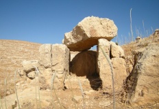
Chambered Tomb in Bulgaria
A Thracian tomb within a mound dating from between the 6th and 2nd centuries BCE. It contains a corridor and two chambers.
You may be viewing yesterday's version of this page. To see the most up to date information please register for a free account.
Do not use the above information on other web sites or publications without permission of the contributor.
Nearby Images from Flickr

The above images may not be of the site on this page, but were taken nearby. They are loaded from Flickr so please click on them for image credits.
Click here to see more info for this site
Nearby sites
Click here to view sites on an interactive map of the areaKey: Red: member's photo, Blue: 3rd party photo, Yellow: other image, Green: no photo - please go there and take one, Grey: site destroyed
Download sites to:
KML (Google Earth)
GPX (GPS waypoints)
CSV (Garmin/Navman)
CSV (Excel)
To unlock full downloads you need to sign up as a Contributory Member. Otherwise downloads are limited to 50 sites.
Turn off the page maps and other distractions
Nearby sites listing. In the following links * = Image available
749m WSW 243° Kran Bronze Age sanctuary Ancient Village or Settlement
3.0km WNW 302° Ostrusha mound* Chambered Tomb
4.4km NW 319° Helvetia mound Chambered Tomb
4.4km NW 322° Shushmanets mound Chambered Tomb
4.5km NW 318° Griffins mound Chambered Tomb
4.8km NW 305° Goliama Kosmatka mound* Ancient Temple
5.8km SSE 165° Kazanlak Tholos Chambered Cairn
6.1km S 170° Kazanlak Museum of History Museum
6.5km WNW 294° Golyama Arsenalka mound Chambered Tomb
11.7km S 182° Buzovgrad Megalith* Burial Chamber or Dolmen
33.6km SE 146° Stara Zagora Neolithic dwellings* Ancient Village or Settlement
38.9km SW 216° The Brothers Megalith* Standing Stones
64.9km WSW 246° Staro Zhelezare Stone Circle
70.7km WSW 255° Starosel Tomb* Ancient Temple
78.3km SW 222° Plovdiv Archaelogical Museum Museum
78.3km SW 222° Eumolpias Ancient Village or Settlement
89.6km SE 145° Chuchul Kamak Standing Stone (Menhir)
91.3km E 98° Cabyle* Ancient Village or Settlement
96.1km SSE 156° Ostur kamuk Dolmen Burial Chamber or Dolmen
98.1km SSW 200° Belintash Ancient Temple
98.3km SE 135° Balgarska Poliana Dolmen* Chambered Tomb
99.3km SE 134° Gaidarov Dolap dolmen Chambered Tomb
100.6km SE 144° Mound near Izvorovo* Round Barrow(s)
104.2km WSW 242° Yunatsite* Ancient Village or Settlement
106.3km S 190° Nenkovo Rock Womb* Cave or Rock Shelter
View more nearby sites and additional images


 We would like to know more about this location. Please feel free to add a brief description and any relevant information in your own language.
 Wir möchten mehr über diese Stätte erfahren. Bitte zögern Sie nicht, eine kurze Beschreibung und relevante Informationen in Deutsch hinzuzufügen.
 Nous aimerions en savoir encore un peu sur les lieux. S'il vous plaît n'hesitez pas à ajouter une courte description et tous les renseignements pertinents dans votre propre langue.
 Quisieramos informarnos un poco más de las lugares. No dude en añadir una breve descripción y otros datos relevantes en su propio idioma.