


<< Our Photo Pages >> Dimitras Temple - Ancient Temple in Greece in Greek Islands
Submitted by AlexHunger on Sunday, 29 October 2006 Page Views: 10096
Neolithic and Bronze AgeSite Name: Dimitras Temple Alternative Name: Temple of GyroulaCountry: Greece
NOTE: This site is 1.255 km away from the location you searched for.
Region: Greek Islands Type: Ancient Temple
Nearest Town: Island of Naxos Nearest Village: Sangrí
Latitude: 37.029035N Longitude: 25.431267E
Condition:
| 5 | Perfect |
| 4 | Almost Perfect |
| 3 | Reasonable but with some damage |
| 2 | Ruined but still recognisable as an ancient site |
| 1 | Pretty much destroyed, possibly visible as crop marks |
| 0 | No data. |
| -1 | Completely destroyed |
| 5 | Superb |
| 4 | Good |
| 3 | Ordinary |
| 2 | Not Good |
| 1 | Awful |
| 0 | No data. |
| 5 | Can be driven to, probably with disabled access |
| 4 | Short walk on a footpath |
| 3 | Requiring a bit more of a walk |
| 2 | A long walk |
| 1 | In the middle of nowhere, a nightmare to find |
| 0 | No data. |
| 5 | co-ordinates taken by GPS or official recorded co-ordinates |
| 4 | co-ordinates scaled from a detailed map |
| 3 | co-ordinates scaled from a bad map |
| 2 | co-ordinates of the nearest village |
| 1 | co-ordinates of the nearest town |
| 0 | no data |
Internal Links:
External Links:
I have visited· I would like to visit
Bjorn MegalithJunkie have visited here
")
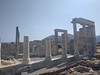
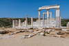
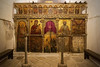
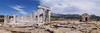
The Ionian temple was dedicated to goddess Dimitra and dates to between 530-520 BCE. The sanctuary of Gyroula is made entirely of white marble. The temple was most probably dedicated to the worship of Demeter and her daughter.The temple was converted into a Church during the 6th century CE. There is a museum with artifacts from the site.
You may be viewing yesterday's version of this page. To see the most up to date information please register for a free account.
")
")
Do not use the above information on other web sites or publications without permission of the contributor.
Nearby Images from Flickr


The above images may not be of the site on this page, but were taken nearby. They are loaded from Flickr so please click on them for image credits.
Click here to see more info for this site
Nearby sites
Click here to view sites on an interactive map of the areaKey: Red: member's photo, Blue: 3rd party photo, Yellow: other image, Green: no photo - please go there and take one, Grey: site destroyed
Download sites to:
KML (Google Earth)
GPX (GPS waypoints)
CSV (Garmin/Navman)
CSV (Excel)
To unlock full downloads you need to sign up as a Contributory Member. Otherwise downloads are limited to 50 sites.
Turn off the page maps and other distractions
Nearby sites listing. In the following links * = Image available
4.9km NNE 31° Menhir of Naxos* Standing Stone (Menhir)
6.1km E 84° Zeus' Cave* Cave or Rock Shelter
6.1km NNE 19° Potami Kouros* Carving
6.3km NNE 17° Flerio Kouros* Carving
7.0km NW 320° Yria Temple* Ancient Temple
9.4km ENE 59° Archaeological Museum of Apiranthos* Museum
10.4km NNW 330° Portara* Ancient Temple
19.6km NNE 32° Apollonas Kouros* Carving
20.0km S 175° Irakleia Spiral shaped petroglyph 2* Rock Art
20.2km S 174° Irakleia - Cyclades Petroglyph 1* Rock Art
20.2km S 174° Irakleia spiral shaped Petroglyph 4* Rock Art
20.3km S 174° Iracleia Calculation Grid* Carving
21.5km S 176° Irakleia Spiral shaped petroglyphs 3 * Rock Art
24.6km SE 128° Keros* Sculptured Stone
33.3km W 263° Spileo Stalaktiton* Cave or Rock Shelter
43.8km NNW 341° Delos Archaeological Museum* Museum
43.8km NNW 341° Delos (Greece)* Ancient Temple
44.4km N 349° Platys Gialos Trilithon* Ancient Village or Settlement
44.6km N 350° Leno Tower* Stone Fort or Dun
47.5km N 355° Paleokastro* Hillfort
47.7km N 349° Mykonos Archaeological Museum Museum
50.1km SW 217° Episkopi (Sikinos)* Ancient Temple
68.1km S 180° Museum of Prehistoric Thera* Museum
72.9km S 177° Episkopi Gonia cemetery* Rock Cut Tomb
73.4km S 177° Zoodochos Pigi* Rock Cut Tomb
View more nearby sites and additional images


 We would like to know more about this location. Please feel free to add a brief description and any relevant information in your own language.
 Wir möchten mehr über diese Stätte erfahren. Bitte zögern Sie nicht, eine kurze Beschreibung und relevante Informationen in Deutsch hinzuzufügen.
 Nous aimerions en savoir encore un peu sur les lieux. S'il vous plaît n'hesitez pas à ajouter une courte description et tous les renseignements pertinents dans votre propre langue.
 Quisieramos informarnos un poco más de las lugares. No dude en añadir una breve descripción y otros datos relevantes en su propio idioma.