


<< Our Photo Pages >> Sigulda Pils - Modern Stone Circle etc in Latvia
Submitted by Alta-Falisa on Monday, 11 August 2014 Page Views: 2324
Modern SitesSite Name: Sigulda PilsCountry: Latvia
NOTE: This site is 25.38 km away from the location you searched for.
Type: Modern Stone Circle etc
Nearest Town: Sigulda
Latitude: 57.164420N Longitude: 24.850990E
Condition:
| 5 | Perfect |
| 4 | Almost Perfect |
| 3 | Reasonable but with some damage |
| 2 | Ruined but still recognisable as an ancient site |
| 1 | Pretty much destroyed, possibly visible as crop marks |
| 0 | No data. |
| -1 | Completely destroyed |
| 5 | Superb |
| 4 | Good |
| 3 | Ordinary |
| 2 | Not Good |
| 1 | Awful |
| 0 | No data. |
| 5 | Can be driven to, probably with disabled access |
| 4 | Short walk on a footpath |
| 3 | Requiring a bit more of a walk |
| 2 | A long walk |
| 1 | In the middle of nowhere, a nightmare to find |
| 0 | No data. |
| 5 | co-ordinates taken by GPS or official recorded co-ordinates |
| 4 | co-ordinates scaled from a detailed map |
| 3 | co-ordinates scaled from a bad map |
| 2 | co-ordinates of the nearest village |
| 1 | co-ordinates of the nearest town |
| 0 | no data |
Internal Links:
External Links:
")
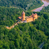
Decorative stone in the garden of Siguldas Jaunā pils (Sigulda's New Castle).
June 2014.
You may be viewing yesterday's version of this page. To see the most up to date information please register for a free account.
")
")
Do not use the above information on other web sites or publications without permission of the contributor.
Nearby Images from Flickr


The above images may not be of the site on this page, but were taken nearby. They are loaded from Flickr so please click on them for image credits.
Click here to see more info for this site
Nearby sites
Click here to view sites on an interactive map of the areaKey: Red: member's photo, Blue: 3rd party photo, Yellow: other image, Green: no photo - please go there and take one, Grey: site destroyed
Download sites to:
KML (Google Earth)
GPX (GPS waypoints)
CSV (Garmin/Navman)
CSV (Excel)
To unlock full downloads you need to sign up as a Contributory Member. Otherwise downloads are limited to 50 sites.
Turn off the page maps and other distractions
Nearby sites listing. In the following links * = Image available
2.0km N 359° Turaida Engraved Stone* Natural Stone / Erratic / Other Natural Feature
31.8km E 93° Ūdri (Pūķi) cross stone* Ancient Cross
50.8km WSW 242° Stone Head of Salaspils replica* Modern Stone Circle etc
51.1km WSW 242° Stone Head of Salaspils* Sculptured Stone
51.2km WSW 243° Latvian National History Museum* Museum
55.8km NNE 23° Davini Great stone (Daviņu Lielais akmens)* Rock Art
60.0km SSE 159° Meļķitāru Muldas akmens* Natural Stone / Erratic / Other Natural Feature
61.8km SSE 164° Kraukļu akmens* Natural Stone / Erratic / Other Natural Feature
70.1km SSE 148° Pastmuižas Velnakmens* Natural Stone / Erratic / Other Natural Feature
79.8km SE 141° Stukmaņu Pētera akmens* Natural Stone / Erratic / Other Natural Feature
111.0km SE 137° Vaiķu Laukakmens* Natural Stone / Erratic / Other Natural Feature
126.5km WSW 239° Pokaini Forest* Ancient Village or Settlement
129.6km W 280° Vandzenes akmens (Stone of Vandzene)* Natural Stone / Erratic / Other Natural Feature
133.5km E 85° Jaunannas Akmen* Marker Stone
140.6km E 95° Medņu dižakmens* Natural Stone / Erratic / Other Natural Feature
145.2km E 90° Lāča Darzs* Modern Stone Circle etc
149.5km SE 138° Nīcgales Lielais Akmens* Natural Stone / Erratic / Other Natural Feature
149.8km WNW 297° Kolkasrags, Jūras Panemtiem* Modern Stone Circle etc
174.1km WSW 242° Vadakstes Valdnieku* Modern Stone Circle etc
174.7km NE 38° Toomemäe ohvrikivi* Holed Stone
180.0km SSE 160° Lūžų akmuo su dubeniu* Holed Stone
185.6km SW 229° Tryškių akmuo* Natural Stone / Erratic / Other Natural Feature
187.3km S 176° Puntuko akmuo* Natural Stone / Erratic / Other Natural Feature
189.9km ENE 70° Izborsk* Hillfort
190.7km S 170° Zarasų akmuo su dubeniu* Holed Stone
View more nearby sites and additional images


 We would like to know more about this location. Please feel free to add a brief description and any relevant information in your own language.
 Wir möchten mehr über diese Stätte erfahren. Bitte zögern Sie nicht, eine kurze Beschreibung und relevante Informationen in Deutsch hinzuzufügen.
 Nous aimerions en savoir encore un peu sur les lieux. S'il vous plaît n'hesitez pas à ajouter une courte description et tous les renseignements pertinents dans votre propre langue.
 Quisieramos informarnos un poco más de las lugares. No dude en añadir una breve descripción y otros datos relevantes en su propio idioma.