

<< Our Photo Pages >> Lissos (Crete) - Ancient Village or Settlement in Greece in Crete
Submitted by Kuba on Friday, 29 November 2019 Page Views: 890
Multi-periodSite Name: Lissos (Crete) Alternative Name: Λίσσος, Lissus, LisoCountry: Greece Region: Crete Type: Ancient Village or Settlement
Nearest Town: Palaiochora Nearest Village: Sougia
Latitude: 35.243522N Longitude: 23.785521E
Condition:
| 5 | Perfect |
| 4 | Almost Perfect |
| 3 | Reasonable but with some damage |
| 2 | Ruined but still recognisable as an ancient site |
| 1 | Pretty much destroyed, possibly visible as crop marks |
| 0 | No data. |
| -1 | Completely destroyed |
| 5 | Superb |
| 4 | Good |
| 3 | Ordinary |
| 2 | Not Good |
| 1 | Awful |
| 0 | No data. |
| 5 | Can be driven to, probably with disabled access |
| 4 | Short walk on a footpath |
| 3 | Requiring a bit more of a walk |
| 2 | A long walk |
| 1 | In the middle of nowhere, a nightmare to find |
| 0 | No data. |
| 5 | co-ordinates taken by GPS or official recorded co-ordinates |
| 4 | co-ordinates scaled from a detailed map |
| 3 | co-ordinates scaled from a bad map |
| 2 | co-ordinates of the nearest village |
| 1 | co-ordinates of the nearest town |
| 0 | no data |
Internal Links:
External Links:
I have visited· I would like to visit
Kuba visited - their rating: Cond: 2 Amb: 5 Access: 3
 (PID:205749)")
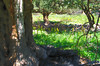
The ruins of ancient Lissos, a harbour settlement to Elyros. It's located in a secluded small valley today partially covered by vegetation. Established in the classical period, it enjoyed prosperity until it was destroyed in 9 century by the Muslims.
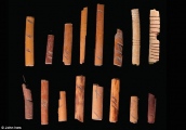
Today there are few remains, but still you can see the ruins of it's impressive Asclepeion (with a relatively well preserved moisaic floor) and the remains of Roman necropolis with vaulted tombs. During the archaeological works there have been also found traces of a theatre, an aqueduct and temples, alongside a numerous and rich votive objects, coins and statues that can be seen in Archaeological Museum of Heraklion and Archaeological Museum of Chania.
The only way to get to ancient Lissos is by boat or walking from Sougia (1,5 h) or Palaiochora (several hours), as it's located on a E4 hiking trail, a fact contributing to the site being off the radar for most of tourists. In the winter months you can be sure to have the site all for yourself (not counting herds of goats benefiting from a source of water located there).
You may be viewing yesterday's version of this page. To see the most up to date information please register for a free account.
 (PID:205750)")
 (PID:205748)")
Do not use the above information on other web sites or publications without permission of the contributor.
Nearby Images from Flickr

The above images may not be of the site on this page, but were taken nearby. They are loaded from Flickr so please click on them for image credits.
Click here to see more info for this site
Nearby sites
Click here to view sites on an interactive map of the areaKey: Red: member's photo, Blue: 3rd party photo, Yellow: other image, Green: no photo - please go there and take one, Grey: site destroyed
Download sites to:
KML (Google Earth)
GPX (GPS waypoints)
CSV (Garmin/Navman)
CSV (Excel)
To unlock full downloads you need to sign up as a Contributory Member. Otherwise downloads are limited to 50 sites.
Turn off the page maps and other distractions
Nearby sites listing. In the following links * = Image available
5.0km N 10° Elyros* Ancient Village or Settlement
35.4km NNW 326° Falasarna* Ancient Village or Settlement
36.9km NE 35° Chania Archaeological Museum* Museum
37.1km NE 35° Kydonia* Ancient Village or Settlement
38.5km NE 53° Stylos Tholos Tomb* Chambered Tomb
38.7km NE 54° Stylos Settlement* Ancient Village or Settlement
40.5km NE 53° Aptera* Ancient Village or Settlement
45.8km NE 50° Minoa (Marathi)* Ancient Village or Settlement
46.8km N 358° Diktynnaion Ancient Temple
50.5km NE 40° Arkoudiotissa Cave* Cave or Rock Shelter
62.0km E 82° Nekropolis Minois* Chambered Tomb
64.0km ENE 77° Archaeological Museum of Rethymno* Museum
65.0km E 83° Vrysinas Ancient Temple
71.3km E 89° Ancient Sanctuary of Hermes* Ancient Temple
81.4km E 83° Elefderna* Ancient Village or Settlement
81.5km E 83° Orthi Petra Rock Cut Tomb
83.5km E 80° Margarites Tholos Tomb* Chambered Tomb
85.7km E 96° Apodoulou (Settlement) Ancient Village or Settlement
86.6km E 96° Apodoulou (Tomb) Passage Grave
91.8km ESE 107° Matala* Rock Cut Tomb
92.4km ESE 106° Kommos* Ancient Village or Settlement
93.7km ESE 103° Kamilari Tholos Tomb* Chambered Tomb
93.8km ESE 102° Agia Triada* Ancient Village or Settlement
94.2km ESE 105° Pitsidia Ancient Village or Settlement
94.9km E 92° Ideon Andron* Cave or Rock Shelter
View more nearby sites and additional images


 We would like to know more about this location. Please feel free to add a brief description and any relevant information in your own language.
 Wir möchten mehr über diese Stätte erfahren. Bitte zögern Sie nicht, eine kurze Beschreibung und relevante Informationen in Deutsch hinzuzufügen.
 Nous aimerions en savoir encore un peu sur les lieux. S'il vous plaît n'hesitez pas à ajouter une courte description et tous les renseignements pertinents dans votre propre langue.
 Quisieramos informarnos un poco más de las lugares. No dude en añadir una breve descripción y otros datos relevantes en su propio idioma.