


<< Our Photo Pages >> Lygourio Pyramid - Pyramid / Mastaba in Greece in Peloponnese Peninsula
Submitted by Antonios on Wednesday, 25 June 2008 Page Views: 5856
Multi-periodSite Name: Lygourio Pyramid Alternative Name: AsclipionCountry: Greece
NOTE: This site is 4.858 km away from the location you searched for.
Region: Peloponnese Peninsula Type: Pyramid / Mastaba
Nearest Town: Nafplio Nearest Village: Lygourio
Latitude: 37.616930N Longitude: 23.030850E
Condition:
| 5 | Perfect |
| 4 | Almost Perfect |
| 3 | Reasonable but with some damage |
| 2 | Ruined but still recognisable as an ancient site |
| 1 | Pretty much destroyed, possibly visible as crop marks |
| 0 | No data. |
| -1 | Completely destroyed |
| 5 | Superb |
| 4 | Good |
| 3 | Ordinary |
| 2 | Not Good |
| 1 | Awful |
| 0 | No data. |
| 5 | Can be driven to, probably with disabled access |
| 4 | Short walk on a footpath |
| 3 | Requiring a bit more of a walk |
| 2 | A long walk |
| 1 | In the middle of nowhere, a nightmare to find |
| 0 | No data. |
| 5 | co-ordinates taken by GPS or official recorded co-ordinates |
| 4 | co-ordinates scaled from a detailed map |
| 3 | co-ordinates scaled from a bad map |
| 2 | co-ordinates of the nearest village |
| 1 | co-ordinates of the nearest town |
| 0 | no data |
Internal Links:
External Links:
")
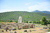
The scant remains of the megalithic cyclopean pyramid at Lygourio. The nearby church of Hagia Marina was constructed from the pyramids reclaimed material. It was dated to 2100 BCE via the method of thermoluminescence.
You may be viewing yesterday's version of this page. To see the most up to date information please register for a free account.
")
")
")
")
Do not use the above information on other web sites or publications without permission of the contributor.
Nearby Images from Flickr


The above images may not be of the site on this page, but were taken nearby. They are loaded from Flickr so please click on them for image credits.
Click here to see more info for this site
Nearby sites
Click here to view sites on an interactive map of the areaKey: Red: member's photo, Blue: 3rd party photo, Yellow: other image, Green: no photo - please go there and take one, Grey: site destroyed
Download sites to:
KML (Google Earth)
GPX (GPS waypoints)
CSV (Garmin/Navman)
CSV (Excel)
To unlock full downloads you need to sign up as a Contributory Member. Otherwise downloads are limited to 50 sites.
Turn off the page maps and other distractions
Nearby sites listing. In the following links * = Image available
8.2km WSW 252° Arkadiko Tholos Tomb* Chambered Tomb
8.6km WSW 253° Kazarma Bridge* Ancient Trackway
9.4km NE 54° Epidaurus Temple of Asklepios* Ancient Temple
16.5km W 267° Tiryns Mycenaean dam* Ancient Mine, Quarry or other Industry
17.0km SW 234° Asine* Ancient Village or Settlement
18.6km WNW 284° Dendra* Chambered Tomb
19.1km WNW 286° Midea* Ancient Village or Settlement
19.4km W 263° Tiryns Tholos* Chambered Cairn
20.4km W 265° Tiryns.* Stone Fort or Dun
21.4km WSW 255° Nafplio Museum* Museum
23.3km SSE 158° Franchthi Cave* Cave or Rock Shelter
23.6km WNW 288° Plataniti Temple of Hera* Ancient Temple
26.3km W 274° Argos Museum* Museum
27.2km WNW 298° Mycenae.* Hillfort
27.2km WNW 297° Treasury of Atreus* Chambered Cairn
27.3km WNW 298° Mycenae Museum* Museum
27.3km WNW 298° Tholos Of Aegistus* Chambered Cairn
27.4km WNW 298° Tholos Of Clytaemnestra* Chambered Cairn
27.4km WNW 298° Tholos Of the Lions* Chambered Cairn
27.5km W 273° Argos Agora* Ancient Village or Settlement
27.5km WNW 297° Panagitsa Tomb* Cairn
27.5km WNW 297° Pano Fournos Tomb* Cairn
27.7km WNW 297° Mycene tomb (9) of the Cyclops* Chambered Tomb
27.7km WNW 297° Tomb of the Genii Cairn
27.8km WNW 297° Cyclopean Tomb* Cairn
View more nearby sites and additional images


 We would like to know more about this location. Please feel free to add a brief description and any relevant information in your own language.
 Wir möchten mehr über diese Stätte erfahren. Bitte zögern Sie nicht, eine kurze Beschreibung und relevante Informationen in Deutsch hinzuzufügen.
 Nous aimerions en savoir encore un peu sur les lieux. S'il vous plaît n'hesitez pas à ajouter une courte description et tous les renseignements pertinents dans votre propre langue.
 Quisieramos informarnos un poco más de las lugares. No dude en añadir una breve descripción y otros datos relevantes en su propio idioma.