


<< Other Photo Pages >> Pavlopetri - Ancient Village or Settlement in Greece in Peloponnese Peninsula
Submitted by coldrum on Thursday, 11 June 2015 Page Views: 17678
Multi-periodSite Name: PavlopetriCountry: Greece Region: Peloponnese Peninsula Type: Ancient Village or Settlement
Nearest Town: Neapoli Voion
Latitude: 36.516980N Longitude: 22.988650E
Condition:
| 5 | Perfect |
| 4 | Almost Perfect |
| 3 | Reasonable but with some damage |
| 2 | Ruined but still recognisable as an ancient site |
| 1 | Pretty much destroyed, possibly visible as crop marks |
| 0 | No data. |
| -1 | Completely destroyed |
| 5 | Superb |
| 4 | Good |
| 3 | Ordinary |
| 2 | Not Good |
| 1 | Awful |
| 0 | No data. |
| 5 | Can be driven to, probably with disabled access |
| 4 | Short walk on a footpath |
| 3 | Requiring a bit more of a walk |
| 2 | A long walk |
| 1 | In the middle of nowhere, a nightmare to find |
| 0 | No data. |
| 5 | co-ordinates taken by GPS or official recorded co-ordinates |
| 4 | co-ordinates scaled from a detailed map |
| 3 | co-ordinates scaled from a bad map |
| 2 | co-ordinates of the nearest village |
| 1 | co-ordinates of the nearest town |
| 0 | no data |
Internal Links:
External Links:
")
The ancient town of Pavlopetri lies in three to four metres of water just off the coast of southern Laconia in Greece. The ruins date from at least 2800 BC through to intact buildings, courtyards, streets, chamber tombs and some thirty-seven cist graves which are thought to belong to the Mycenaean period (c.1680-1180 BC). This Bronze Age phase of Greece provides the historical setting for much Ancient Greek literature and myth, including Homer's Age of Heroes.
The submerged buildings, courtyards, streets, tombs and graves, lie just off a sandy stretch of beach close to an area popular with holiday makers and campers. Under threat from tourism and industry the remains are being damaged by boats dragging their anchors, inquisitive snorkelers on the hunt for souvenirs and the growth of marine organisms which are also taking their toll degrading the fragile 3,500 year old walls.
Note: Video Talk: Humanity and a Million Years of Sea Level Change by Dr Nicholas Flemming from the Institute of Oceanography at the University of Southampton, see the latest comment on our page
You may be viewing yesterday's version of this page. To see the most up to date information please register for a free account.
")
")
")
Do not use the above information on other web sites or publications without permission of the contributor.
Nearby Images from Flickr


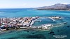
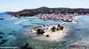
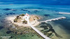

The above images may not be of the site on this page, but were taken nearby. They are loaded from Flickr so please click on them for image credits.
Click here to see more info for this site
Nearby sites
Click here to view sites on an interactive map of the areaKey: Red: member's photo, Blue: 3rd party photo, Yellow: other image, Green: no photo - please go there and take one, Grey: site destroyed
Download sites to:
KML (Google Earth)
GPX (GPS waypoints)
CSV (Garmin/Navman)
CSV (Excel)
To unlock full downloads you need to sign up as a Contributory Member. Otherwise downloads are limited to 50 sites.
Turn off the page maps and other distractions
Nearby sites listing. In the following links * = Image available
24.0km N 8° Epidaurus Limera* Ancient Village or Settlement
31.2km NNE 16° Zarax* Ancient Village or Settlement
46.7km WSW 254° Tainarios* Ancient Temple
55.8km WNW 284° Alepotrypa Cave* Cave or Rock Shelter
58.4km WNW 288° Kalamakia Cave* Cave or Rock Shelter
68.6km NW 319° Agios Vasileios Ancient Palace
72.7km NW 321° Vafio* Chambered Tomb
75.1km NW 320° Sanctuary of Apollo, Amycleos* Ancient Temple
77.4km NW 322° Menelaion* Ancient Temple
77.8km NNW 347° Soha tombs Ancient Village or Settlement
79.4km NW 321° Sparta museum* Museum
79.9km NW 321° Tomb of Leonidas* Ancient Temple
80.5km NW 321° Sparta (Greece)* Ancient Village or Settlement
96.7km WNW 289° Apollo Temple of Koroni* Ancient Temple
99.4km NNE 14° Hermione Temple of Poseidon Ancient Temple
101.5km N 7° Franchthi Cave* Cave or Rock Shelter
102.9km WNW 292° Sanctuary of Apollo Korythos* Ancient Temple
106.4km WNW 298° Petalidi* Ancient Temple
107.3km WNW 289° Kaplani Tomb Passage Grave
110.1km WNW 300° Nichoria* Ancient Village or Settlement
112.9km N 355° Asine* Ancient Village or Settlement
114.2km NNE 16° Troizen Temple Ancient Temple
114.2km NNE 16° Troezen* Ancient Village or Settlement
114.3km NNE 16° Sanctuary of Asclepios Ancient Temple
114.4km NNE 19° Galatas Mycenaean Tombs* Cairn
View more nearby sites and additional images


 We would like to know more about this location. Please feel free to add a brief description and any relevant information in your own language.
 Wir möchten mehr über diese Stätte erfahren. Bitte zögern Sie nicht, eine kurze Beschreibung und relevante Informationen in Deutsch hinzuzufügen.
 Nous aimerions en savoir encore un peu sur les lieux. S'il vous plaît n'hesitez pas à ajouter une courte description et tous les renseignements pertinents dans votre propre langue.
 Quisieramos informarnos un poco más de las lugares. No dude en añadir una breve descripción y otros datos relevantes en su propio idioma.