


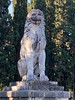
<< Our Photo Pages >> Lion of Chaeronea - Carving in Greece in Central Greece
Submitted by davidmorgan on Saturday, 13 December 2008 Page Views: 8549
Multi-periodSite Name: Lion of ChaeroneaCountry: Greece
NOTE: This site is 0.261 km away from the location you searched for.
Region: Central Greece Type: Carving
Nearest Town: Cheronia
Latitude: 38.494939N Longitude: 22.848303E
Condition:
| 5 | Perfect |
| 4 | Almost Perfect |
| 3 | Reasonable but with some damage |
| 2 | Ruined but still recognisable as an ancient site |
| 1 | Pretty much destroyed, possibly visible as crop marks |
| 0 | No data. |
| -1 | Completely destroyed |
| 5 | Superb |
| 4 | Good |
| 3 | Ordinary |
| 2 | Not Good |
| 1 | Awful |
| 0 | No data. |
| 5 | Can be driven to, probably with disabled access |
| 4 | Short walk on a footpath |
| 3 | Requiring a bit more of a walk |
| 2 | A long walk |
| 1 | In the middle of nowhere, a nightmare to find |
| 0 | No data. |
| 5 | co-ordinates taken by GPS or official recorded co-ordinates |
| 4 | co-ordinates scaled from a detailed map |
| 3 | co-ordinates scaled from a bad map |
| 2 | co-ordinates of the nearest village |
| 1 | co-ordinates of the nearest town |
| 0 | no data |
Internal Links:
External Links:
I have visited· I would like to visit
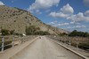
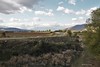
bat400 visited on 29th May 2011 - their rating: Cond: 4 Amb: 3 Access: 5 The open area where the monument is sited is now a grassy depression with a semicircular plaza around it.
davidmorgan have visited here
")
A monument to the Thebans who were wiped out by the Macedonians Philip II and his son Alexander in 338 BCE.
Added by bat400: Pausanias (2nd C AD) wrote in his Description of Greece: "As you approach the city you see a common grave of the Thebans who were killed in the struggle against Philip. It has no inscription, but is surmounted by a lion, probably a reference to the spirit of the men." (English Translation: W.H.S. Jones, Litt.D., and H.A. Ormerod, M.A. Cambridge, MA, Harvard University Press; 1918. )
Fragments of this monument were discovered in 1818 at the site of a grave mound later found to have 254 sets of remains, supporting it as the burial mound of the Theban Sacred Band. The lion monument was re-constructed but some of what exists today is a modern speculative creation.
The monument is just to the east of the Chaeronea Archaeological Museum with its displays of the prehistoric through Roman periods.
Traditionally the lion faces the grave mound of the Macedonians.
You may be viewing yesterday's version of this page. To see the most up to date information please register for a free account.
Do not use the above information on other web sites or publications without permission of the contributor.
davidmorgan has found this location on Google Street View:
Nearby Images from Flickr


The above images may not be of the site on this page, but were taken nearby. They are loaded from Flickr so please click on them for image credits.
Click here to see more info for this site
Nearby sites
Click here to view sites on an interactive map of the areaKey: Red: member's photo, Blue: 3rd party photo, Yellow: other image, Green: no photo - please go there and take one, Grey: site destroyed
Download sites to:
KML (Google Earth)
GPX (GPS waypoints)
CSV (Garmin/Navman)
CSV (Excel)
To unlock full downloads you need to sign up as a Contributory Member. Otherwise downloads are limited to 50 sites.
Turn off the page maps and other distractions
Nearby sites listing. In the following links * = Image available
3.0km E 88° Macedonian Tumulus at Chaeronea Chambered Tomb
7.3km S 172° Lebadeia Temple of Zeus* Ancient Temple
10.6km E 91° Orchomenos Temple Ancient Temple
11.0km E 91° Treasury of Minyas* Cairn
11.2km NNE 32° Abai (Greece)* Ancient Village or Settlement
12.3km NNE 24° Hyampolis* Ancient Village or Settlement
16.3km NNE 15° Hyampolis Sanctuary of Artemis and Apollo* Ancient Temple
18.4km N 350° Elateia Temple of Athena Kranaia Ancient Temple
29.4km E 92° Gla.* Hillfort
30.2km W 267° Delphi Temple* Ancient Temple
35.3km E 96° Sanctuary of Apollo Ptoios* Ancient Temple
45.1km ESE 115° Thebes Museum* Museum
45.6km ESE 115° Thebes Mycenaean Tomb* Rock Cut Tomb
45.8km ESE 116° Temple of Apollo Ismenios Ancient Temple
48.1km SE 129° Ancient Plataea* Ancient Village or Settlement
50.6km SE 139° Shrine of Melampous* Ancient Temple
50.9km SE 139° Aigosthena Fortress* Stone Fort or Dun
51.9km S 180° Heraion of Perachora* Ancient Temple
57.8km SE 127° Eleutherae* Promontory Fort / Cliff Castle
58.0km SSW 192° Sikyon Temple of Artemis* Ancient Temple
61.4km S 171° Diolkos* Ancient Trackway
62.3km SE 126° Tower of Oinoe* Promontory Fort / Cliff Castle
62.7km S 176° Korakou* Ancient Village or Settlement
64.1km WSW 236° Pounta Diakopto* Standing Stone (Menhir)
64.1km WSW 236° Pounta Diakopto Stones* Natural Stone / Erratic / Other Natural Feature
View more nearby sites and additional images


 We would like to know more about this location. Please feel free to add a brief description and any relevant information in your own language.
 Wir möchten mehr über diese Stätte erfahren. Bitte zögern Sie nicht, eine kurze Beschreibung und relevante Informationen in Deutsch hinzuzufügen.
 Nous aimerions en savoir encore un peu sur les lieux. S'il vous plaît n'hesitez pas à ajouter une courte description et tous les renseignements pertinents dans votre propre langue.
 Quisieramos informarnos un poco más de las lugares. No dude en añadir una breve descripción y otros datos relevantes en su propio idioma.