


<< Other Photo Pages >> Trajan's Roman Bridge - Ancient Trackway in Romania
Submitted by TheDruid-3X3 on Monday, 05 December 2022 Page Views: 512
Multi-periodSite Name: Trajan's Roman Bridge Alternative Name: Podul Lui TraianCountry: Romania
NOTE: This site is 45.56 km away from the location you searched for.
Type: Ancient Trackway
Nearest Town: Kladovo Nearest Village: Kostol
Latitude: 44.623611N Longitude: 22.666944E
Condition:
| 5 | Perfect |
| 4 | Almost Perfect |
| 3 | Reasonable but with some damage |
| 2 | Ruined but still recognisable as an ancient site |
| 1 | Pretty much destroyed, possibly visible as crop marks |
| 0 | No data. |
| -1 | Completely destroyed |
| 5 | Superb |
| 4 | Good |
| 3 | Ordinary |
| 2 | Not Good |
| 1 | Awful |
| 0 | No data. |
| 5 | Can be driven to, probably with disabled access |
| 4 | Short walk on a footpath |
| 3 | Requiring a bit more of a walk |
| 2 | A long walk |
| 1 | In the middle of nowhere, a nightmare to find |
| 0 | No data. |
| 5 | co-ordinates taken by GPS or official recorded co-ordinates |
| 4 | co-ordinates scaled from a detailed map |
| 3 | co-ordinates scaled from a bad map |
| 2 | co-ordinates of the nearest village |
| 1 | co-ordinates of the nearest town |
| 0 | no data |
Internal Links:
External Links:
")
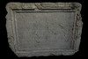
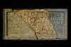
The Trajan Bridge was built between the years 103 to 105 AD east of the Iron Gate Rapids at Turnu Severin to guarantee the supply line of Roman legions during the conquest of Dacia (modern-day Romania). The bridge consisted of timber arches mounted on masonry piers spanning the 800-metre-wide stretch of the river and had a total length of over 1000 metres. A century and a half later the emperor Aurelian withdrew from Dacia and demolished the bridge. Its 54-metre spans were the longest ever constructed at the time and would not be surpassed for more than a thousand years. Today the only visible remains of the bridge are the approach sections in the village of Kostol on the Serbian riverbank and in the city of Turnu Severin on the left Romanian riverbank.
Forgotten for centuries, the remains of the bridge reappeared in 1858 when the level of the Danube hit a record low due to an extensive drought. Initial archaeological research and excavation of the bridge was carried out during the 1980s as part of the Iron Gates Dam construction project. The underwater pillars on the bed of the Danube, their position and level of preservation were examined using a special vessel equipped with sonar. This was the first time that the length of the bridge, amounting to just under 1,070 metres, had been precisely measured.
In 2003, exactly 19 centuries after the beginning of its construction, the Serbian Ministry of Culture financed an underwater archaeological project to carry out comprehensive research on the remains of the bridge. Conducted by the Institute for the Protection of Cultural Monuments of Serbia, the purpose of the project was to provide answers to a number of questions, including what construction materials and techniques had been used to sink the pillars into the riverbed and what the exact dimensions, shape and height of the bridge were.
You may be viewing yesterday's version of this page. To see the most up to date information please register for a free account.
")
")
Do not use the above information on other web sites or publications without permission of the contributor.
Nearby Images from Flickr


The above images may not be of the site on this page, but were taken nearby. They are loaded from Flickr so please click on them for image credits.
Click here to see more info for this site
Nearby sites
Click here to view sites on an interactive map of the areaKey: Red: member's photo, Blue: 3rd party photo, Yellow: other image, Green: no photo - please go there and take one, Grey: site destroyed
Download sites to:
KML (Google Earth)
GPX (GPS waypoints)
CSV (Garmin/Navman)
CSV (Excel)
To unlock full downloads you need to sign up as a Contributory Member. Otherwise downloads are limited to 50 sites.
Turn off the page maps and other distractions
Nearby sites listing. In the following links * = Image available
5.0km W 275° Schela Cladovei* Ancient Village or Settlement
28.4km W 278° Tabula Traiana* Carving
29.8km W 274° The face of Dacian King Decebalus* Sculptured Stone
51.3km W 262° Lepenski Vir* Ancient Village or Settlement
56.5km WSW 238° Rudna Glava Ancient Mine, Quarry or other Industry
66.0km NNE 34° Priest's Cave* Rock Art
74.2km W 273° Chindiei 2 Cave* Rock Art
85.8km SSW 201° Zaječar museum* Museum
89.4km SSW 206° Felix Romuliana* Ancient Palace
104.5km NNE 27° Banita Dacian citadel Hillfort
114.3km W 277° Viminacium* Ancient Village or Settlement
115.2km NNE 19° Luncani-Piatra Rosie Dacian citadel* Hillfort
121.9km NNE 24° Sarmizegetusa Regia citadel* Hillfort
122.0km NNE 24° Sarmizegetusa Regia Sacred Well* Holy Well or Sacred Spring
122.0km NNE 24° Sarmizegetusa Regia Circle* Stone Circle
122.0km NNE 24° Sarmizegetusa Regia Sanctuary* Ancient Temple
122.1km NNE 18° Mihu Tower* Stone Fort or Dun
122.1km NNE 18° Ardeu Dacian Hillfort* Hillfort
122.5km NNE 18° Costesti-Blidaru Dacian citadel* Hillfort
123.5km NNE 18° Costesti-Cetatuie Dacian citadel* Hillfort
131.2km SW 230° Zavičajni Muzej Paraćin* Museum
133.2km ESE 114° Olt Burial Site Round Cairn
140.2km NNE 12° Simeria mound* Artificial Mound
140.6km NNE 12° Magura Uroiului* Ancient Village or Settlement
143.2km WSW 247° Grncarica Ancient Village or Settlement
View more nearby sites and additional images


 We would like to know more about this location. Please feel free to add a brief description and any relevant information in your own language.
 Wir möchten mehr über diese Stätte erfahren. Bitte zögern Sie nicht, eine kurze Beschreibung und relevante Informationen in Deutsch hinzuzufügen.
 Nous aimerions en savoir encore un peu sur les lieux. S'il vous plaît n'hesitez pas à ajouter une courte description et tous les renseignements pertinents dans votre propre langue.
 Quisieramos informarnos un poco más de las lugares. No dude en añadir una breve descripción y otros datos relevantes en su propio idioma.