

<< Other Photo Pages >> Tomb of Philip II - Chambered Cairn in Greece in Northern Greece
Submitted by AlexHunger on Sunday, 29 October 2006 Page Views: 4869
Neolithic and Bronze AgeSite Name: Tomb of Philip II Alternative Name: Great TumulusCountry: Greece
NOTE: This site is 10.647 km away from the location you searched for.
Region: Northern Greece Type: Chambered Cairn
Nearest Town: Veria Nearest Village: Vergina
Latitude: 40.487438N Longitude: 22.319665E
Condition:
| 5 | Perfect |
| 4 | Almost Perfect |
| 3 | Reasonable but with some damage |
| 2 | Ruined but still recognisable as an ancient site |
| 1 | Pretty much destroyed, possibly visible as crop marks |
| 0 | No data. |
| -1 | Completely destroyed |
| 5 | Superb |
| 4 | Good |
| 3 | Ordinary |
| 2 | Not Good |
| 1 | Awful |
| 0 | No data. |
| 5 | Can be driven to, probably with disabled access |
| 4 | Short walk on a footpath |
| 3 | Requiring a bit more of a walk |
| 2 | A long walk |
| 1 | In the middle of nowhere, a nightmare to find |
| 0 | No data. |
| 5 | co-ordinates taken by GPS or official recorded co-ordinates |
| 4 | co-ordinates scaled from a detailed map |
| 3 | co-ordinates scaled from a bad map |
| 2 | co-ordinates of the nearest village |
| 1 | co-ordinates of the nearest town |
| 0 | no data |
Internal Links:
External Links:
I have visited· I would like to visit
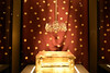
bat400 visited on 7th May 2017 - their rating: Cond: 2 Amb: 5 Access: 5 The Great Mound was apparently an overgrown but noted site into modern times when excavated formally in the 1970's. Now the multiple tombs and graves are displayed in this museum setting, with the beautiful finds along side the tombs. The lighting is very dim at first and especially when they first open each day, the site is very crowded, but in 2017, the site appears to be open into the early evening and the crowds die down by mid afternoon.
davidmorgan have visited here
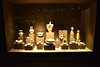
The royal tombs in the Great Tumulus includes three Macedonian tombs and one cist-grave. One of them was the tomb of King Philip II and another probably belonged to King Alexander IV. These two graves were found unplundered and are lavishly decorated with splendid wall paintings.
Note: No photographs allowed inside the mound, unfortunately. All the finds are now on display here and very well presented.
You may be viewing yesterday's version of this page. To see the most up to date information please register for a free account.
Do not use the above information on other web sites or publications without permission of the contributor.
davidmorgan has found this location on Google Street View:
Nearby Images from Flickr


The above images may not be of the site on this page, but were taken nearby. They are loaded from Flickr so please click on them for image credits.
Click here to see more info for this site
Nearby sites
Click here to view sites on an interactive map of the areaKey: Red: member's photo, Blue: 3rd party photo, Yellow: other image, Green: no photo - please go there and take one, Grey: site destroyed
Download sites to:
KML (Google Earth)
GPX (GPS waypoints)
CSV (Garmin/Navman)
CSV (Excel)
To unlock full downloads you need to sign up as a Contributory Member. Otherwise downloads are limited to 50 sites.
Turn off the page maps and other distractions
Nearby sites listing. In the following links * = Image available
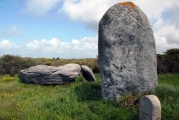
1.0km SSE 167° Vergina* Ancient Village or Settlement
24.0km NW 321° Fleurons Macedonian Tomb* Chambered Tomb
24.1km NW 320° Krisis Macedonian Tomb* Chambered Tomb
24.3km NW 319° Kinch's Macedonian Tomb* Chambered Tomb
24.5km NW 319° Lyson and Kallicleus Macedonian Tomb* Chambered Tomb
24.5km NW 310° School of Aristotle* NOT SET
24.7km NW 311° Mieza* Ancient Village or Settlement
28.3km ESE 115° Pydna* Ancient Village or Settlement
34.2km NNE 29° Pella (Greece)* Ancient Village or Settlement
35.5km NNE 21° Giannitsa Archontikon* Ancient Village or Settlement
37.5km SSE 157° Dio.* Ancient Village or Settlement
40.9km NNW 327° Edessa* Ancient Village or Settlement
53.5km ENE 78° Karabournaki* Ancient Village or Settlement
94.5km S 175° Larissa (Thessaly)* Ancient Village or Settlement
100.9km NW 306° Heraclea* Ancient Village or Settlement
100.9km NW 323° Pavla chuka Burial Chamber or Dolmen
103.9km SW 215° Metéora* Natural Stone / Erratic / Other Natural Feature
105.0km SSW 211° Theopetra Cave Cave or Rock Shelter
105.6km ESE 115° Amon Temple of Zeus Ancient Temple
106.1km ESE 115° Aphitis Temple of Zeus Ammon Ancient Temple
107.3km ESE 123° Temple of Poseidon, Posseidi* Ancient Temple
108.2km NNE 14° Tsarevi Kuli Ancient Village or Settlement
110.6km NNW 327° The Great Goddess with three faces* Natural Stone / Erratic / Other Natural Feature
122.0km NNW 346° Stobi* Ancient Village or Settlement
125.2km E 84° Stagira* Ancient Temple
View more nearby sites and additional images


 We would like to know more about this location. Please feel free to add a brief description and any relevant information in your own language.
 Wir möchten mehr über diese Stätte erfahren. Bitte zögern Sie nicht, eine kurze Beschreibung und relevante Informationen in Deutsch hinzuzufügen.
 Nous aimerions en savoir encore un peu sur les lieux. S'il vous plaît n'hesitez pas à ajouter une courte description et tous les renseignements pertinents dans votre propre langue.
 Quisieramos informarnos un poco más de las lugares. No dude en añadir una breve descripción y otros datos relevantes en su propio idioma.