


<< Our Photo Pages >> Fleurons Macedonian Tomb - Chambered Tomb in Greece in Northern Greece
Submitted by SolarMegalith on Friday, 15 October 2010 Page Views: 3913
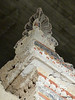
Neolithic and Bronze AgeSite Name: Fleurons Macedonian Tomb Alternative Name: Tomb of the PalmettesCountry: Greece
NOTE: This site is 7.26 km away from the location you searched for.
Region: Northern Greece Type: Chambered Tomb
Nearest Town: Lefkadia
Latitude: 40.654743N Longitude: 22.139371E
Condition:
| 5 | Perfect |
| 4 | Almost Perfect |
| 3 | Reasonable but with some damage |
| 2 | Ruined but still recognisable as an ancient site |
| 1 | Pretty much destroyed, possibly visible as crop marks |
| 0 | No data. |
| -1 | Completely destroyed |
| 5 | Superb |
| 4 | Good |
| 3 | Ordinary |
| 2 | Not Good |
| 1 | Awful |
| 0 | No data. |
| 5 | Can be driven to, probably with disabled access |
| 4 | Short walk on a footpath |
| 3 | Requiring a bit more of a walk |
| 2 | A long walk |
| 1 | In the middle of nowhere, a nightmare to find |
| 0 | No data. |
| 5 | co-ordinates taken by GPS or official recorded co-ordinates |
| 4 | co-ordinates scaled from a detailed map |
| 3 | co-ordinates scaled from a bad map |
| 2 | co-ordinates of the nearest village |
| 1 | co-ordinates of the nearest town |
| 0 | no data |
Internal Links:
External Links:
I have visited· I would like to visit
rrmoser would like to visit
")
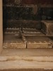
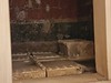
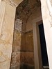
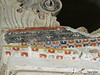
Located most to the east among Lefkadia tombs, this Macedonian tomb is dated for first half of 3rd century BC. It's name comes from the characteristic fleuron ornaments.
You may be viewing yesterday's version of this page. To see the most up to date information please register for a free account.
")
")
Do not use the above information on other web sites or publications without permission of the contributor.
davidmorgan has found this location on Google Street View:
Nearby Images from Flickr

The above images may not be of the site on this page, but were taken nearby. They are loaded from Flickr so please click on them for image credits.
Click here to see more info for this site
Nearby sites
Click here to view sites on an interactive map of the areaKey: Red: member's photo, Blue: 3rd party photo, Yellow: other image, Green: no photo - please go there and take one, Grey: site destroyed
Download sites to:
KML (Google Earth)
GPX (GPS waypoints)
CSV (Garmin/Navman)
CSV (Excel)
To unlock full downloads you need to sign up as a Contributory Member. Otherwise downloads are limited to 50 sites.
Turn off the page maps and other distractions
Nearby sites listing. In the following links * = Image available
246m WSW 255° Krisis Macedonian Tomb* Chambered Tomb
766m WSW 250° Kinch's Macedonian Tomb* Chambered Tomb
1000m WSW 256° Lyson and Kallicleus Macedonian Tomb* Chambered Tomb
4.3km SW 234° Mieza* Ancient Village or Settlement
4.4km SW 231° School of Aristotle* NOT SET
17.2km NNW 336° Edessa* Ancient Village or Settlement
24.0km SE 141° Tomb of Philip II* Chambered Cairn
25.0km SE 142° Vergina* Ancient Village or Settlement
31.3km ENE 62° Giannitsa Archontikon* Ancient Village or Settlement
33.9km ENE 71° Pella (Greece)* Ancient Village or Settlement
51.0km SE 126° Pydna* Ancient Village or Settlement
61.0km SSE 151° Dio.* Ancient Village or Settlement
68.0km E 96° Karabournaki* Ancient Village or Settlement
76.9km NW 323° Pavla chuka Burial Chamber or Dolmen
77.9km WNW 301° Heraclea* Ancient Village or Settlement
86.8km NNW 329° The Great Goddess with three faces* Natural Stone / Erratic / Other Natural Feature
95.7km NNE 25° Tsarevi Kuli Ancient Village or Settlement
100.9km N 352° Stobi* Ancient Village or Settlement
113.0km SSW 203° Metéora* Natural Stone / Erratic / Other Natural Feature
115.2km SSE 168° Larissa (Thessaly)* Ancient Village or Settlement
115.3km SSW 200° Theopetra Cave Cave or Rock Shelter
118.2km W 272° Vashtëmi* Ancient Village or Settlement
119.0km WNW 289° Ohrid Bay of Bones Museum* Ancient Village or Settlement
119.9km W 265° Kamenicë Tumulus Round Barrow(s)
124.2km WNW 295° Ohrid Ancient Village or Settlement
View more nearby sites and additional images


 We would like to know more about this location. Please feel free to add a brief description and any relevant information in your own language.
 Wir möchten mehr über diese Stätte erfahren. Bitte zögern Sie nicht, eine kurze Beschreibung und relevante Informationen in Deutsch hinzuzufügen.
 Nous aimerions en savoir encore un peu sur les lieux. S'il vous plaît n'hesitez pas à ajouter une courte description et tous les renseignements pertinents dans votre propre langue.
 Quisieramos informarnos un poco más de las lugares. No dude en añadir una breve descripción y otros datos relevantes en su propio idioma.