 with our Megalithic Portal iPhone app")


<< Text Pages >> Sanctuary of Zeus Ithomatas - Ancient Temple in Greece in Peloponnese Peninsula
Submitted by Klingon on Saturday, 22 July 2017 Page Views: 892
Neolithic and Bronze AgeSite Name: Sanctuary of Zeus Ithomatas Alternative Name: Ιερά της ΙθώμηςCountry: Greece Region: Peloponnese Peninsula Type: Ancient Temple
Latitude: 37.185900N Longitude: 21.924700E
Condition:
| 5 | Perfect |
| 4 | Almost Perfect |
| 3 | Reasonable but with some damage |
| 2 | Ruined but still recognisable as an ancient site |
| 1 | Pretty much destroyed, possibly visible as crop marks |
| 0 | No data. |
| -1 | Completely destroyed |
| 5 | Superb |
| 4 | Good |
| 3 | Ordinary |
| 2 | Not Good |
| 1 | Awful |
| 0 | No data. |
| 5 | Can be driven to, probably with disabled access |
| 4 | Short walk on a footpath |
| 3 | Requiring a bit more of a walk |
| 2 | A long walk |
| 1 | In the middle of nowhere, a nightmare to find |
| 0 | No data. |
| 5 | co-ordinates taken by GPS or official recorded co-ordinates |
| 4 | co-ordinates scaled from a detailed map |
| 3 | co-ordinates scaled from a bad map |
| 2 | co-ordinates of the nearest village |
| 1 | co-ordinates of the nearest town |
| 0 | no data |
Internal Links:
External Links:
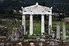
Ancient Temple in Peloponnese Peninsula
You may be viewing yesterday's version of this page. To see the most up to date information please register for a free account.
Do not use the above information on other web sites or publications without permission of the contributor.
Nearby Images from Flickr
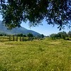
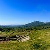
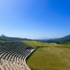
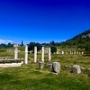
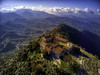
The above images may not be of the site on this page, but were taken nearby. They are loaded from Flickr so please click on them for image credits.
Click here to see more info for this site
Nearby sites
Click here to view sites on an interactive map of the areaKey: Red: member's photo, Blue: 3rd party photo, Yellow: other image, Green: no photo - please go there and take one, Grey: site destroyed
Download sites to:
KML (Google Earth)
GPX (GPS waypoints)
CSV (Garmin/Navman)
CSV (Excel)
To unlock full downloads you need to sign up as a Contributory Member. Otherwise downloads are limited to 50 sites.
Turn off the page maps and other distractions
Nearby sites listing. In the following links * = Image available
671m SSE 158° Eileithyia* Ancient Temple
930m SSE 149° Artemis Limnatis* Ancient Temple
1.0km W 276° Arkadian Gate* Hillfort
1.2km SSW 198° Ancient Messene* Ancient Village or Settlement
1.5km SE 132° Lakonian Gate* Hillfort
9.6km NNW 334° Malthi* Chambered Tomb
19.2km WNW 302° Peristeria* Passage Grave
20.3km S 183° Nichoria* Ancient Village or Settlement
23.3km SW 231° Archaeological Museum of Chora* Museum
24.5km NNE 23° Lykosoura Despoina Sanctuary* Ancient Temple
25.3km S 179° Petalidi* Ancient Temple
26.8km SW 229° Nestors Palace Tholos Tomb* Passage Grave
27.0km SW 229° Mycenaean Palace of Nestor* Ancient Palace
27.2km N 355° Bassae Temple of Apollo* Ancient Temple
27.9km SW 229° Mycenaean Tholos Tomb near Nestors Palace* Passage Grave
28.4km SW 222° Iklaina* Ancient Village or Settlement
28.8km NE 38° Despoina Sanctuary.* Ancient Temple
29.5km N 11° Sanctuary of Zeus (Mount Lykaion)* Ancient Temple
29.9km NNE 12° Lykaion Lower Sanctuary* Ancient Temple
30.6km SW 226° Korifasiou* Passage Grave
30.7km NE 36° Ancient theater of Megalopolis* Ancient Village or Settlement
31.1km NE 35° Ancient Megalopoli* Ancient Temple
31.1km SW 229° Viglitsa* Chambered Tomb
33.3km NNW 328° Lepreon* Ancient Temple
33.9km SW 224° Thrasymedes tomb* Passage Grave
View more nearby sites and additional images


 We would like to know more about this location. Please feel free to add a brief description and any relevant information in your own language.
 Wir möchten mehr über diese Stätte erfahren. Bitte zögern Sie nicht, eine kurze Beschreibung und relevante Informationen in Deutsch hinzuzufügen.
 Nous aimerions en savoir encore un peu sur les lieux. S'il vous plaît n'hesitez pas à ajouter une courte description et tous les renseignements pertinents dans votre propre langue.
 Quisieramos informarnos un poco más de las lugares. No dude en añadir una breve descripción y otros datos relevantes en su propio idioma.