 with our Megalithic Portal iPhone app")


<< Our Photo Pages >> Grodzisko Szczaworyż - Hillfort in Poland in Swietokrzyskie
Submitted by SolarMegalith on Saturday, 02 July 2011 Page Views: 3531
Iron Age and Later PrehistorySite Name: Grodzisko Szczaworyż Alternative Name: Grodzisko Kapturowa GóraCountry: Poland
NOTE: This site is 9.782 km away from the location you searched for.
Voivodeship: Swietokrzyskie Type: Hillfort
Nearest Town: Busko Zdrój Nearest Village: Szczaworyż
Latitude: 50.441944N Longitude: 20.802500E
Condition:
| 5 | Perfect |
| 4 | Almost Perfect |
| 3 | Reasonable but with some damage |
| 2 | Ruined but still recognisable as an ancient site |
| 1 | Pretty much destroyed, possibly visible as crop marks |
| 0 | No data. |
| -1 | Completely destroyed |
| 5 | Superb |
| 4 | Good |
| 3 | Ordinary |
| 2 | Not Good |
| 1 | Awful |
| 0 | No data. |
| 5 | Can be driven to, probably with disabled access |
| 4 | Short walk on a footpath |
| 3 | Requiring a bit more of a walk |
| 2 | A long walk |
| 1 | In the middle of nowhere, a nightmare to find |
| 0 | No data. |
| 5 | co-ordinates taken by GPS or official recorded co-ordinates |
| 4 | co-ordinates scaled from a detailed map |
| 3 | co-ordinates scaled from a bad map |
| 2 | co-ordinates of the nearest village |
| 1 | co-ordinates of the nearest town |
| 0 | no data |
Internal Links:
External Links:
I have visited· I would like to visit
SolarMegalith visited on 19th Oct 2018 - their rating: Cond: 4 Amb: 4 Access: 4
")
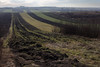
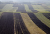
A well-preserved early medieval hillfort in Szczaworyż is dated for the 8th-9th century AD. It was one of the major strongholds of the Tribal period in this part of Poland. Its earthworks with rampart and ditch are rectangular in shape.
You may be viewing yesterday's version of this page. To see the most up to date information please register for a free account.
")
")
")
")
Do not use the above information on other web sites or publications without permission of the contributor.
Nearby Images from Flickr
The above images may not be of the site on this page, but were taken nearby. They are loaded from Flickr so please click on them for image credits.
Click here to see more info for this site
Nearby sites
Click here to view sites on an interactive map of the areaKey: Red: member's photo, Blue: 3rd party photo, Yellow: other image, Green: no photo - please go there and take one, Grey: site destroyed
Download sites to:
KML (Google Earth)
GPX (GPS waypoints)
CSV (Garmin/Navman)
CSV (Excel)
To unlock full downloads you need to sign up as a Contributory Member. Otherwise downloads are limited to 50 sites.
Turn off the page maps and other distractions
Nearby sites listing. In the following links * = Image available
3.0km NNW 341° Kurhan Żerniki Górne Round Barrow(s)
13.9km SW 219° Grodzisko Wiślica* Hillfort
17.4km SSW 202° Czarkowy - Kopiec Kościuszki Round Barrow(s)
17.7km SW 225° Kurhany Kolosy* Round Barrow(s)
24.6km SSW 211° Kurhan Królewice* Round Barrow(s)
34.7km WSW 253° Kurhan Szczotkowice Round Barrow(s)
37.8km WSW 246° Kurhan Pałecznica Round Barrow(s)
49.9km NNE 21° Łysa Góra Sacred Mountain* Misc. Earthwork
50.6km NNE 23° Pielgrzym Sculpture* Sculptured Stone
52.8km SSE 164° Grodzisko Zawada (Tarnów)* Hillfort
56.5km SSW 191° Grodzisko Jadowniki Podgórne* Hillfort
59.4km NE 56° Kurhan Leszczków Round Barrow(s)
60.6km SSW 211° Grodzisko Łapczyca Hillfort
61.0km NNW 345° Tumlin Earthwork* Misc. Earthwork
62.1km NE 54° Malice Kościelne Megalithic Tomb Long Barrow
62.8km S 179° Grodzisko Roztoka* Promontory Fort / Cliff Castle
63.4km S 181° Grodzisko Zawada Lanckorońska* Hillfort
65.8km SW 217° Kurhan Krakuszowice Round Barrow(s)
66.6km SW 232° Kopiec Wandy* Artificial Mound
68.2km NE 55° Kurhan Łopata Round Barrow(s)
68.6km NNW 332° Dobrzeszowska Góra* Misc. Earthwork
70.2km SW 219° Kurhany Jawczyce Barrow Cemetery
71.1km SSE 147° Grodzisko Przeczyca* Hillfort
73.3km W 271° Grodzisko Udórz Hillfort
73.9km SE 125° Kurhan Witkowice Round Barrow(s)
View more nearby sites and additional images


 We would like to know more about this location. Please feel free to add a brief description and any relevant information in your own language.
 Wir möchten mehr über diese Stätte erfahren. Bitte zögern Sie nicht, eine kurze Beschreibung und relevante Informationen in Deutsch hinzuzufügen.
 Nous aimerions en savoir encore un peu sur les lieux. S'il vous plaît n'hesitez pas à ajouter une courte description et tous les renseignements pertinents dans votre propre langue.
 Quisieramos informarnos un poco más de las lugares. No dude en añadir una breve descripción y otros datos relevantes en su propio idioma.