


<< Other Photo Pages >> Vinca Belo Brdo - Ancient Village or Settlement in Serbia
Submitted by davidmorgan on Monday, 13 April 2015 Page Views: 2411
Multi-periodSite Name: Vinca Belo Brdo Alternative Name: Vinča-Belo BrdoCountry: Serbia
NOTE: This site is 33.266 km away from the location you searched for.
Type: Ancient Village or Settlement
Nearest Town: Belgrade Nearest Village: Vinča
Latitude: 44.762062N Longitude: 20.623103E
Condition:
| 5 | Perfect |
| 4 | Almost Perfect |
| 3 | Reasonable but with some damage |
| 2 | Ruined but still recognisable as an ancient site |
| 1 | Pretty much destroyed, possibly visible as crop marks |
| 0 | No data. |
| -1 | Completely destroyed |
| 5 | Superb |
| 4 | Good |
| 3 | Ordinary |
| 2 | Not Good |
| 1 | Awful |
| 0 | No data. |
| 5 | Can be driven to, probably with disabled access |
| 4 | Short walk on a footpath |
| 3 | Requiring a bit more of a walk |
| 2 | A long walk |
| 1 | In the middle of nowhere, a nightmare to find |
| 0 | No data. |
| 5 | co-ordinates taken by GPS or official recorded co-ordinates |
| 4 | co-ordinates scaled from a detailed map |
| 3 | co-ordinates scaled from a bad map |
| 2 | co-ordinates of the nearest village |
| 1 | co-ordinates of the nearest town |
| 0 | no data |
Internal Links:
External Links:
I have visited· I would like to visit
Kuba would like to visit
A settlement on the bank of the Danube River occupied by people of the Early Neolithic Starčevo culture from 5700 BCE and then by the Vinča culture from 5200 BCE to 4900 BCE.
You may be viewing yesterday's version of this page. To see the most up to date information please register for a free account.
Do not use the above information on other web sites or publications without permission of the contributor.
davidmorgan has found this location on Google Street View:
Nearby Images from Flickr
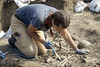
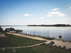
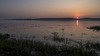
The above images may not be of the site on this page, but were taken nearby. They are loaded from Flickr so please click on them for image credits.
Click here to see more info for this site
Nearby sites
Click here to view sites on an interactive map of the areaKey: Red: member's photo, Blue: 3rd party photo, Yellow: other image, Green: no photo - please go there and take one, Grey: site destroyed
Download sites to:
KML (Google Earth)
GPX (GPS waypoints)
CSV (Garmin/Navman)
CSV (Excel)
To unlock full downloads you need to sign up as a Contributory Member. Otherwise downloads are limited to 50 sites.
Turn off the page maps and other distractions
Nearby sites listing. In the following links * = Image available
14.3km WNW 295° National Museum in Belgrade* Museum
48.0km E 94° Viminacium* Ancient Village or Settlement
78.3km SSE 157° Grncarica Ancient Village or Settlement
88.3km E 97° Chindiei 2 Cave* Rock Art
100.6km S 185° Mrcajevci Barrow Cemetery
103.7km NNE 22° Parta Neolithic Sanctuary* Ancient Temple
113.3km E 101° Lepenski Vir* Ancient Village or Settlement
117.7km SSE 148° Zavičajni Muzej Paraćin* Museum
119.9km NNE 23° Museum of Banat Museum
121.6km NNE 24° Timisoara Modern Stone Circle Modern Stone Circle etc
123.0km ESE 111° Rudna Glava Ancient Mine, Quarry or other Industry
132.5km E 95° The face of Dacian King Decebalus* Sculptured Stone
133.9km E 94° Tabula Traiana* Carving
138.7km NNE 20° Cornesti-Iarcuri Bronze Age Fortification Misc. Earthwork
142.4km SSE 157° Narodni Muzej Kruševac* Museum
154.8km N 1° Bekai halom Ancient Village or Settlement
156.8km SE 127° Felix Romuliana* Ancient Palace
157.2km N 10° Ziridava Ancient Village or Settlement
157.3km E 95° Schela Cladovei* Ancient Village or Settlement
162.3km E 95° Trajan's Roman Bridge* Ancient Trackway
162.6km SE 125° Zaječar museum* Museum
175.2km WNW 301° Osijek Ancient Village or Settlement
182.4km SSE 161° Pločnik* Ancient Village or Settlement
189.9km SSE 147° Narodni muzej Niš* Museum
196.9km SE 143° Balanica Cave Cave or Rock Shelter
View more nearby sites and additional images


 We would like to know more about this location. Please feel free to add a brief description and any relevant information in your own language.
 Wir möchten mehr über diese Stätte erfahren. Bitte zögern Sie nicht, eine kurze Beschreibung und relevante Informationen in Deutsch hinzuzufügen.
 Nous aimerions en savoir encore un peu sur les lieux. S'il vous plaît n'hesitez pas à ajouter une courte description et tous les renseignements pertinents dans votre propre langue.
 Quisieramos informarnos un poco más de las lugares. No dude en añadir una breve descripción y otros datos relevantes en su propio idioma.