

<< Our Photo Pages >> Grodzisko Klasztorzysko - Hillfort in Poland in Malopolskie
Submitted by SolarMegalith on Friday, 21 August 2020 Page Views: 351
Iron Age and Later PrehistorySite Name: Grodzisko KlasztorzyskoCountry: Poland
NOTE: This site is 9.714 km away from the location you searched for.
Voivodeship: Malopolskie Type: Hillfort
Nearest Town: Dobczyce Nearest Village: Dąbie
Latitude: 49.815222N Longitude: 20.157917E
Condition:
| 5 | Perfect |
| 4 | Almost Perfect |
| 3 | Reasonable but with some damage |
| 2 | Ruined but still recognisable as an ancient site |
| 1 | Pretty much destroyed, possibly visible as crop marks |
| 0 | No data. |
| -1 | Completely destroyed |
| 5 | Superb |
| 4 | Good |
| 3 | Ordinary |
| 2 | Not Good |
| 1 | Awful |
| 0 | No data. |
| 5 | Can be driven to, probably with disabled access |
| 4 | Short walk on a footpath |
| 3 | Requiring a bit more of a walk |
| 2 | A long walk |
| 1 | In the middle of nowhere, a nightmare to find |
| 0 | No data. |
| 5 | co-ordinates taken by GPS or official recorded co-ordinates |
| 4 | co-ordinates scaled from a detailed map |
| 3 | co-ordinates scaled from a bad map |
| 2 | co-ordinates of the nearest village |
| 1 | co-ordinates of the nearest town |
| 0 | no data |
Internal Links:
External Links:
I have visited· I would like to visit
SolarMegalith visited on 13th Jun 2020 - their rating: Cond: 4 Amb: 5 Access: 3
")
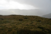
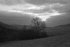
An irregular-shaped hillfort occupies one of the summits south of the village of Dąbie. The earthworks survived in good condition, especially in western and eastern part of the fort. Archaeological excavations conducted in the 1950s revealed traces of occupation associated with Puchov culture (La Tene period).
You may be viewing yesterday's version of this page. To see the most up to date information please register for a free account.
")
")
")
Do not use the above information on other web sites or publications without permission of the contributor.
Nearby Images from Flickr
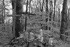

The above images may not be of the site on this page, but were taken nearby. They are loaded from Flickr so please click on them for image credits.
Click here to see more info for this site
Nearby sites
Click here to view sites on an interactive map of the areaKey: Red: member's photo, Blue: 3rd party photo, Yellow: other image, Green: no photo - please go there and take one, Grey: site destroyed
Download sites to:
KML (Google Earth)
GPX (GPS waypoints)
CSV (Garmin/Navman)
CSV (Excel)
To unlock full downloads you need to sign up as a Contributory Member. Otherwise downloads are limited to 50 sites.
Turn off the page maps and other distractions
Nearby sites listing. In the following links * = Image available
886m W 280° Grodzisko Poznachowice Górne* Hillfort
15.1km N 7° Kurhany Jawczyce Barrow Cemetery
18.2km NNE 21° Kurhan Krakuszowice Round Barrow(s)
23.2km NE 41° Grodzisko Łapczyca Hillfort
28.6km NNW 330° Kopiec Krakusa* Artificial Mound
29.1km NNW 347° Kopiec Wandy* Artificial Mound
31.0km NNW 329° Kraków - Wawel* Ancient Village or Settlement
31.3km NNW 330° Archaeological Museum of Kraków* Museum
36.3km W 277° Grodzisko Bugaj* Hillfort
36.8km SE 142° Grodzisko Góra Zyndrama Hillfort
37.2km WNW 302° Wołowice Flint Mine Ancient Mine, Quarry or other Industry
37.9km ENE 68° Grodzisko Jadowniki Podgórne* Hillfort
39.7km SE 132° Grodzisko Grobla - Podegrodzie* Hillfort
40.2km ESE 113° Grodzisko Marcinkowice* Hillfort
40.7km W 259° Muzeum Miejskie Suchej Beskidzkiej* Museum
41.0km W 263° Grodzisko Zembrzyce* Promontory Fort / Cliff Castle
41.0km ESE 118° Grodzisko Chełmiec* Hillfort
41.3km E 100° Grodzisko Małpia Wyspa* Hillfort
41.3km NW 311° Grodzisko Mników Hillfort
41.6km SE 135° Grodzisko Naszacowice* Hillfort
45.8km E 82° Grodzisko Zawada Lanckorońska* Hillfort
46.8km W 275° Grodzisko Gorzeń Górny* Hillfort
46.9km NNW 328° Jaskinia Mamutowa* Cave or Rock Shelter
47.2km NNW 328° Jaskinia Wierzchowska Górna* Cave or Rock Shelter
48.1km E 81° Grodzisko Roztoka* Promontory Fort / Cliff Castle
View more nearby sites and additional images


 We would like to know more about this location. Please feel free to add a brief description and any relevant information in your own language.
 Wir möchten mehr über diese Stätte erfahren. Bitte zögern Sie nicht, eine kurze Beschreibung und relevante Informationen in Deutsch hinzuzufügen.
 Nous aimerions en savoir encore un peu sur les lieux. S'il vous plaît n'hesitez pas à ajouter une courte description et tous les renseignements pertinents dans votre propre langue.
 Quisieramos informarnos un poco más de las lugares. No dude en añadir una breve descripción y otros datos relevantes en su propio idioma.