


<< Our Photo Pages >> Les Pierres Plates (Anglards-de-Salers) - Burial Chamber or Dolmen in France in Auvergne:Cantal (15)
Submitted by TheCaptain on Wednesday, 08 September 2010 Page Views: 2259
Neolithic and Bronze AgeSite Name: Les Pierres Plates (Anglards-de-Salers)Country: France
NOTE: This site is 8.438 km away from the location you searched for.
Département: Auvergne:Cantal (15) Type: Burial Chamber or Dolmen
Nearest Town: Maurrac Nearest Village: Anglards-de-Salers
Latitude: 45.204200N Longitude: 2.440200E
Condition:
| 5 | Perfect |
| 4 | Almost Perfect |
| 3 | Reasonable but with some damage |
| 2 | Ruined but still recognisable as an ancient site |
| 1 | Pretty much destroyed, possibly visible as crop marks |
| 0 | No data. |
| -1 | Completely destroyed |
| 5 | Superb |
| 4 | Good |
| 3 | Ordinary |
| 2 | Not Good |
| 1 | Awful |
| 0 | No data. |
| 5 | Can be driven to, probably with disabled access |
| 4 | Short walk on a footpath |
| 3 | Requiring a bit more of a walk |
| 2 | A long walk |
| 1 | In the middle of nowhere, a nightmare to find |
| 0 | No data. |
| 5 | co-ordinates taken by GPS or official recorded co-ordinates |
| 4 | co-ordinates scaled from a detailed map |
| 3 | co-ordinates scaled from a bad map |
| 2 | co-ordinates of the nearest village |
| 1 | co-ordinates of the nearest town |
| 0 | no data |
Internal Links:
External Links:
I have visited· I would like to visit
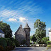
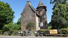
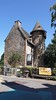
alchemille visited on 8th May 2014 - their rating: Cond: 3 Amb: 4 Access: 5 The pierres plates (because there are two) are found in the town centre, on both sides of the road near the fountain leading to the church. Precisely in the route from Mauriac to Montclard.
"La pierre plate" consists then in a cap stone 2m by 0.90. On the other side of the road we find a small cap stone of bearly 1m long by 0.60 but this small one is broken and has been repared by a blacksmith.
 (PID:119810)")
from alchemille
"The pierres plates (because there are two) are found in the town centre, on both sides of the road near the fountain leading to the church. Precisely in the route from Mauriac to Montclard. "La pierre plate" consists then in a cap stone 2m by 0.90. On the other side of the road we find a small cap stone of bearly 1m long by 0.60 but this small one is broken and has been repared by a blacksmith."
You may be viewing yesterday's version of this page. To see the most up to date information please register for a free account.
 (PID:119811)")
 (PID:119812)")
Do not use the above information on other web sites or publications without permission of the contributor.
Nearby Images from Flickr
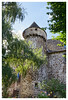
The above images may not be of the site on this page, but were taken nearby. They are loaded from Flickr so please click on them for image credits.
Click here to see more info for this site
Nearby sites
Click here to view sites on an interactive map of the areaKey: Red: member's photo, Blue: 3rd party photo, Yellow: other image, Green: no photo - please go there and take one, Grey: site destroyed
Download sites to:
KML (Google Earth)
GPX (GPS waypoints)
CSV (Garmin/Navman)
CSV (Excel)
To unlock full downloads you need to sign up as a Contributory Member. Otherwise downloads are limited to 50 sites.
Turn off the page maps and other distractions
Nearby sites listing. In the following links * = Image available
12.9km NW 320° Menhir d'Arches* Standing Stone (Menhir)
14.5km NNE 22° Oppidum de Chastel-Marlhac Ancient Village or Settlement
15.9km N 4° Menhir dit Pierre de Justice Standing Stone (Menhir)
17.8km W 261° Dolmen dit les Pierres des Géants Burial Chamber or Dolmen
18.2km SW 232° Dolmen dit Pierres des Géants Burial Chamber or Dolmen
18.9km NE 51° Cabanes de Châteauneuf Ancient Village or Settlement
19.0km NE 51° Dolmen de Cousti* Burial Chamber or Dolmen
25.9km W 269° La Peyre-Quillade Standing Stone (Menhir)
26.6km NNE 18° Dolmen de Frau (Lanobre) Burial Chamber or Dolmen
27.4km SSE 169° St Simon menhir* Standing Stone (Menhir)
27.7km N 353° Dolmen de Marly Burial Chamber or Dolmen
28.2km SSW 200° Dolmen d'Ayrens * Burial Chamber or Dolmen
29.1km SSW 212° Nieudan burial chamber* Burial Chamber or Dolmen
30.0km SSW 213° Dolmen dit Peyrelevade Burial Chamber or Dolmen
30.3km NW 311° Peyre-Fade Standing Stone (Menhir)
33.8km ESE 104° Village Fortifie Prehistorique de la Roche Hillfort
33.9km NW 309° Menhir de la Croix du Cardaire Standing Stone (Menhir)
36.8km SSE 167° Peyreficade Menhir* Standing Stone (Menhir)
37.1km N 9° Chemin Fais'Art* Modern Stone Circle etc
37.6km S 188° Menhir de Madunhac* Standing Stone (Menhir)
38.0km ESE 103° Cabanes des Fraux Ancient Village or Settlement
38.1km NW 306° Menhir de Trappe Standing Stone (Menhir)
38.2km NW 306° Menhir de Bolle Grande Standing Stone (Menhir)
39.3km E 85° Dolmen dit la Pierre au Prat* Burial Chamber or Dolmen
39.4km NNW 345° Camp de César Ancient Village or Settlement
View more nearby sites and additional images


 We would like to know more about this location. Please feel free to add a brief description and any relevant information in your own language.
 Wir möchten mehr über diese Stätte erfahren. Bitte zögern Sie nicht, eine kurze Beschreibung und relevante Informationen in Deutsch hinzuzufügen.
 Nous aimerions en savoir encore un peu sur les lieux. S'il vous plaît n'hesitez pas à ajouter une courte description et tous les renseignements pertinents dans votre propre langue.
 Quisieramos informarnos un poco más de las lugares. No dude en añadir una breve descripción y otros datos relevantes en su propio idioma.