

<< Our Photo Pages >> St Simon menhir - Standing Stone (Menhir) in France in Auvergne:Cantal (15)
Submitted by TheCaptain on Wednesday, 08 September 2010 Page Views: 2482
Neolithic and Bronze AgeSite Name: St Simon menhirCountry: France
NOTE: This site is 5.85 km away from the location you searched for.
Département: Auvergne:Cantal (15) Type: Standing Stone (Menhir)
Nearest Town: Aurillac Nearest Village: St Simon
Latitude: 44.962200N Longitude: 2.508700E
Condition:
| 5 | Perfect |
| 4 | Almost Perfect |
| 3 | Reasonable but with some damage |
| 2 | Ruined but still recognisable as an ancient site |
| 1 | Pretty much destroyed, possibly visible as crop marks |
| 0 | No data. |
| -1 | Completely destroyed |
| 5 | Superb |
| 4 | Good |
| 3 | Ordinary |
| 2 | Not Good |
| 1 | Awful |
| 0 | No data. |
| 5 | Can be driven to, probably with disabled access |
| 4 | Short walk on a footpath |
| 3 | Requiring a bit more of a walk |
| 2 | A long walk |
| 1 | In the middle of nowhere, a nightmare to find |
| 0 | No data. |
| 5 | co-ordinates taken by GPS or official recorded co-ordinates |
| 4 | co-ordinates scaled from a detailed map |
| 3 | co-ordinates scaled from a bad map |
| 2 | co-ordinates of the nearest village |
| 1 | co-ordinates of the nearest town |
| 0 | no data |
Internal Links:
External Links:
I have visited· I would like to visit
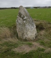
alchemille visited on 27th Oct 2013 - their rating: Cond: 4 Amb: 4 Access: 5 Hexagonal menhir with an iron cross on top. It's 1.65m high and 40cm wide. It is found in the intersection of the road to Mazeyrac, following the route d'Estive, or otherwise the Departmental road D58 to Giou de Mamou.
")
You may be viewing yesterday's version of this page. To see the most up to date information please register for a free account.
")
Do not use the above information on other web sites or publications without permission of the contributor.
Nearby Images from Flickr
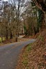

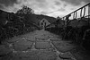

The above images may not be of the site on this page, but were taken nearby. They are loaded from Flickr so please click on them for image credits.
Click here to see more info for this site
Nearby sites
Click here to view sites on an interactive map of the areaKey: Red: member's photo, Blue: 3rd party photo, Yellow: other image, Green: no photo - please go there and take one, Grey: site destroyed
Download sites to:
KML (Google Earth)
GPX (GPS waypoints)
CSV (Garmin/Navman)
CSV (Excel)
To unlock full downloads you need to sign up as a Contributory Member. Otherwise downloads are limited to 50 sites.
Turn off the page maps and other distractions
Nearby sites listing. In the following links * = Image available
9.4km SSE 163° Peyreficade Menhir* Standing Stone (Menhir)
14.7km SW 225° Menhir de Madunhac* Standing Stone (Menhir)
15.0km W 271° Dolmen d'Ayrens * Burial Chamber or Dolmen
21.0km W 276° Nieudan burial chamber* Burial Chamber or Dolmen
22.0km W 275° Dolmen dit Peyrelevade Burial Chamber or Dolmen
25.2km NW 309° Dolmen dit Pierres des Géants Burial Chamber or Dolmen
27.4km NNW 349° Les Pierres Plates (Anglards-de-Salers)* Burial Chamber or Dolmen
28.1km E 92° Menhirs de Gourdièges Standing Stone (Menhir)
31.5km E 81° Paulhac burial chamber Burial Chamber or Dolmen
31.6km SSW 204° Cromlech de la Rouquette* Stone Circle
32.7km ESE 117° Menhir de la Baisse des Mazes Standing Stone (Menhir)
33.1km NE 56° Village Fortifie Prehistorique de la Roche Hillfort
33.4km NW 317° Dolmen dit les Pierres des Géants Burial Chamber or Dolmen
35.3km E 80° Dolmen de Lapeyre Burial Chamber or Dolmen
36.0km E 86° Alleuzet Dolmen* Burial Chamber or Dolmen
36.4km E 92° Menhir du Bois des Sagnes Standing Stone (Menhir)
36.5km ENE 60° Cabanes des Fraux Ancient Village or Settlement
37.7km ENE 74° Pierre-du-Loup (Valuejols)* Burial Chamber or Dolmen
39.1km E 87° Bargueyrac Menhir* Standing Stone (Menhir)
39.1km ESE 108° Menhir d'Arjalet Standing Stone (Menhir)
39.3km NNW 340° Menhir d'Arches* Standing Stone (Menhir)
39.5km E 86° La Table au Loup* Burial Chamber or Dolmen
39.8km NNE 14° Cabanes de Châteauneuf Ancient Village or Settlement
39.9km NNE 14° Dolmen de Cousti* Burial Chamber or Dolmen
40.3km N 0° Oppidum de Chastel-Marlhac Ancient Village or Settlement
View more nearby sites and additional images


 We would like to know more about this location. Please feel free to add a brief description and any relevant information in your own language.
 Wir möchten mehr über diese Stätte erfahren. Bitte zögern Sie nicht, eine kurze Beschreibung und relevante Informationen in Deutsch hinzuzufügen.
 Nous aimerions en savoir encore un peu sur les lieux. S'il vous plaît n'hesitez pas à ajouter une courte description et tous les renseignements pertinents dans votre propre langue.
 Quisieramos informarnos un poco más de las lugares. No dude en añadir una breve descripción y otros datos relevantes en su propio idioma.