


<< Our Photo Pages >> Tefessedt - Ancient Village or Settlement in Algeria
Submitted by AlexHunger on Friday, 18 April 2008 Page Views: 2908
Multi-periodSite Name: Tefessedt Alternative Name: ChenouaCountry: Algeria
NOTE: This site is 9.424 km away from the location you searched for.
Type: Ancient Village or Settlement
Nearest Town: Wilaya Nearest Village: Tipasa
Latitude: 36.593961N Longitude: 2.442999E
Condition:
| 5 | Perfect |
| 4 | Almost Perfect |
| 3 | Reasonable but with some damage |
| 2 | Ruined but still recognisable as an ancient site |
| 1 | Pretty much destroyed, possibly visible as crop marks |
| 0 | No data. |
| -1 | Completely destroyed |
| 5 | Superb |
| 4 | Good |
| 3 | Ordinary |
| 2 | Not Good |
| 1 | Awful |
| 0 | No data. |
| 5 | Can be driven to, probably with disabled access |
| 4 | Short walk on a footpath |
| 3 | Requiring a bit more of a walk |
| 2 | A long walk |
| 1 | In the middle of nowhere, a nightmare to find |
| 0 | No data. |
| 5 | co-ordinates taken by GPS or official recorded co-ordinates |
| 4 | co-ordinates scaled from a detailed map |
| 3 | co-ordinates scaled from a bad map |
| 2 | co-ordinates of the nearest village |
| 1 | co-ordinates of the nearest town |
| 0 | no data |
Internal Links:
External Links:
I have visited· I would like to visit
SimonBlackmore has visited here
")
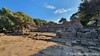
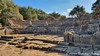
On the shores of the Mediterranean, Tipasa was an ancient Phoenician or Punic trading-post or Emporium conquered by Rome and turned into a strategic base for the conquest of the kingdoms of Mauritania. It was made a Roman military colony by the emperor Claudius, and afterwards became a municipium. It comprises a unique group of Phoenician, Roman, palaeochristian and Byzantine ruins alongside indigenous monuments such as the Kbor er Roumia, the great royal mausoleum of Mauritania.
Unesco World heritage site.
You may be viewing yesterday's version of this page. To see the most up to date information please register for a free account.
")
")
Do not use the above information on other web sites or publications without permission of the contributor.
Nearby Images from Flickr
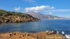
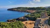
The above images may not be of the site on this page, but were taken nearby. They are loaded from Flickr so please click on them for image credits.
Click here to see more info for this site
Nearby sites
Click here to view sites on an interactive map of the areaKey: Red: member's photo, Blue: 3rd party photo, Yellow: other image, Green: no photo - please go there and take one, Grey: site destroyed
Download sites to:
KML (Google Earth)
GPX (GPS waypoints)
CSV (Garmin/Navman)
CSV (Excel)
To unlock full downloads you need to sign up as a Contributory Member. Otherwise downloads are limited to 50 sites.
Turn off the page maps and other distractions
Nearby sites listing. In the following links * = Image available
10.1km ESE 102° Tombeau de la Chrétienne* Pyramid / Mastaba
22.6km W 273° Iol.* Ancient Village or Settlement
56.9km ENE 71° Ikosim Ancient Village or Settlement
252.9km NNW 340° Ca Na Costa* Passage Grave
270.9km NNW 339° Sa Caleta Ancient Village or Settlement
271.5km NNW 340° Pou Roig* Holy Well or Sacred Spring
272.1km E 99° Dejmila* Ancient Village or Settlement
272.2km NNW 341° Puig Des Molins* Museum
274.4km NNW 338° Font den Xiquet* Holy Well or Sacred Spring
277.6km NNW 339° Font de Verger* Holy Well or Sacred Spring
281.9km NNW 344° Font de Peralta* Holy Well or Sacred Spring
283.1km NNW 341° Pou de Forada* Holy Well or Sacred Spring
284.0km NNW 343° Font de Balafi* Holy Well or Sacred Spring
284.6km NNW 343° Pou d’Albarqueta Holy Well or Sacred Spring
286.9km NNW 345° Cova d'Es Cuieram Cave or Rock Shelter
287.4km NNW 343° Pou de Labritja* Holy Well or Sacred Spring
288.5km NNW 344° Pou des Baladre* Holy Well or Sacred Spring
289.0km NNW 342° Font des ses Torres Holy Well or Sacred Spring
305.2km NW 306° Peña Negra* Ancient Village or Settlement
306.9km N 11° Punta des Baus* Ancient Village or Settlement
308.9km N 10° Ets Antigors* Ancient Village or Settlement
310.9km N 6° Talaies de Cala Pi* Ancient Village or Settlement
312.7km N 8° Talaiot de Ca n'Estela* Broch or Nuraghe
313.6km N 6° Capocorb Vell* Ancient Village or Settlement
315.4km N 11° Talaies de Can Jordi* Ancient Village or Settlement
View more nearby sites and additional images


 We would like to know more about this location. Please feel free to add a brief description and any relevant information in your own language.
 Wir möchten mehr über diese Stätte erfahren. Bitte zögern Sie nicht, eine kurze Beschreibung und relevante Informationen in Deutsch hinzuzufügen.
 Nous aimerions en savoir encore un peu sur les lieux. S'il vous plaît n'hesitez pas à ajouter une courte description et tous les renseignements pertinents dans votre propre langue.
 Quisieramos informarnos un poco más de las lugares. No dude en añadir una breve descripción y otros datos relevantes en su propio idioma.