

<< Our Photo Pages >> Túmulo de Son Ferrer - Round Barrow(s) in Spain in Balearic Isles (Mallorca / Majorca)
Submitted by Ogneslav on Monday, 15 September 2014 Page Views: 3489
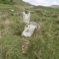
Neolithic and Bronze AgeSite Name: Túmulo de Son Ferrer Alternative Name: Turriforme Escalonado de Son FerrerCountry: Spain Region: Balearic Isles (Mallorca / Majorca) Type: Round Barrow(s)
Nearest Town: Santa Ponça Nearest Village: Son Ferrer
Latitude: 39.493330N Longitude: 2.499080E
Condition:
| 5 | Perfect |
| 4 | Almost Perfect |
| 3 | Reasonable but with some damage |
| 2 | Ruined but still recognisable as an ancient site |
| 1 | Pretty much destroyed, possibly visible as crop marks |
| 0 | No data. |
| -1 | Completely destroyed |
| 5 | Superb |
| 4 | Good |
| 3 | Ordinary |
| 2 | Not Good |
| 1 | Awful |
| 0 | No data. |
| 5 | Can be driven to, probably with disabled access |
| 4 | Short walk on a footpath |
| 3 | Requiring a bit more of a walk |
| 2 | A long walk |
| 1 | In the middle of nowhere, a nightmare to find |
| 0 | No data. |
| 5 | co-ordinates taken by GPS or official recorded co-ordinates |
| 4 | co-ordinates scaled from a detailed map |
| 3 | co-ordinates scaled from a bad map |
| 2 | co-ordinates of the nearest village |
| 1 | co-ordinates of the nearest town |
| 0 | no data |
Internal Links:
External Links:
I have visited· I would like to visit
sem has visited here
")
The funerary use of the complex lasted till the beginning of the 3rd century AD.
During the thorough excavations the remains of 101 humans were found among those only 10 were adults (sex men and four women).
Further are the exact reprints from several information boards installed around the site.
«TALAYÓTIC PHASE
(850-500 BC)
By excavating the stepped tower-form they have been able to establish how these little known architectural structures were built. The conserved structures were built between 850 and 750 BC. The main building was built within a solid quadrangular structure. The central structure was surrounded by oval walls made of solid blocks of sandstone and earth. The end result gives this construction an irregular stepped appearance.
POSTALAYÓTIC PHASE
(500-200 BC)
The stepped tower-form was used as a Funeral area / burial ground from 500 BC. 101 individuals were buried in artificial caves until 200 BC. The funeral ritual was different for the 37 foetuses neo-natal and pre-natal remains, as they were buried in ceramic containers.
The rest of the remains (49 infants, 4 youths and 11 adults) were deposited directly in the caves. After analysis herbal remains were found along with flower offerings and little flower vases.
POSTALAYÓTIC PHASE
(200-75 BC)
Around 200 BC the community were forced to use the access corridor for burials because of the lack of space. This was clearly divided into two areas. The first area was used exclusively for the remains of Neo-natales and Peri-Natales. They were buried in sandstone and hand made ceramics. In the second area they deposited vases related to the funeral ritual, such as small Roman indigenous ceramic containers.
As from 200 BC the space within the artificial cave was insufficient. Due to this, the Prehistoric Community used other areas of the stepped tower-form to bury their people, emptying and re-utilizing the space between the walls of the structure. Here they buried the remains of five new-borns, three of them in sandstone pots and two of them in ancient vases reutilized as funeral containers.
While the slope area of the stepped tower-form was used as a funeral area, the west slope was used in a different way. In this zone 4 rooms were built of which only two have been clearly conserved. These were used as storage rooms for products relating to the Funeral rituals».
References:
In English - Matching Data: Analyzing the Chronological Use Sequence in the Iron Age Necropolis of the Staggered Turriform of Son Ferrer (Balearic Islands, Spain)
In Spanish - Talayots.es, la guía de la prehistoria de Mallorca y Menorca
You may be viewing yesterday's version of this page. To see the most up to date information please register for a free account.
")
")
")
")
")
")
")
")
Do not use the above information on other web sites or publications without permission of the contributor.
Click here to see more info for this site
Nearby sites
Click here to view sites on an interactive map of the areaKey: Red: member's photo, Blue: 3rd party photo, Yellow: other image, Green: no photo - please go there and take one, Grey: site destroyed
Download sites to:
KML (Google Earth)
GPX (GPS waypoints)
CSV (Garmin/Navman)
CSV (Excel)
To unlock full downloads you need to sign up as a Contributory Member. Otherwise downloads are limited to 50 sites.
Turn off the page maps and other distractions
Nearby sites listing. In the following links * = Image available
1.7km NW 321° Túmulo de Son Miralles* Artificial Mound
1.8km NW 318° Talayot de Son Miralles* Broch or Nuraghe
1.8km NNW 330° Santa Ponça 20* Ancient Village or Settlement
2.0km NW 325° Santa Ponça 5* Ancient Village or Settlement
2.2km NW 315° Poblat del Puig de sa Morisca* Ancient Village or Settlement
2.3km E 81° Naveta Alemany* Ancient Village or Settlement
15.4km ENE 58° Museu de Mallorca* Museum
18.9km ENE 73° Son Oms santuario* Ancient Temple
24.6km NNE 17° Son Oleza Ancient Village or Settlement
25.9km NNE 20° The Maze, Mallorca Ancient Village or Settlement
26.1km NNE 20° Son Mas* Ancient Temple
29.9km ESE 111° Capocorb Vell* Ancient Village or Settlement
30.9km E 92° Son Noguera* Broch or Nuraghe
32.8km ESE 114° Talaies de Cala Pi* Ancient Village or Settlement
38.3km E 80° Son Coll Nou Broch or Nuraghe
38.7km NE 48° Es Castellot Ancient Village or Settlement
38.9km ENE 63° Camp del Bisbe* Cave or Rock Shelter
39.9km ENE 62° Son Fred* Broch or Nuraghe
41.0km ENE 66° Binifat* Broch or Nuraghe
41.3km ENE 64° Son Corro* Ancient Village or Settlement
41.4km ENE 76° Son Fornes Settlement* Ancient Village or Settlement
42.1km ENE 67° Es Turassot* Ancient Village or Settlement
42.1km ESE 108° Talaiot de Ca n'Estela* Broch or Nuraghe
42.7km ENE 76° Campanari des Moros* Broch or Nuraghe
42.7km ENE 78° Archaeological Museum of Son Fornés* Museum
View more nearby sites and additional images


 We would like to know more about this location. Please feel free to add a brief description and any relevant information in your own language.
 Wir möchten mehr über diese Stätte erfahren. Bitte zögern Sie nicht, eine kurze Beschreibung und relevante Informationen in Deutsch hinzuzufügen.
 Nous aimerions en savoir encore un peu sur les lieux. S'il vous plaît n'hesitez pas à ajouter une courte description et tous les renseignements pertinents dans votre propre langue.
 Quisieramos informarnos un poco más de las lugares. No dude en añadir una breve descripción y otros datos relevantes en su propio idioma.