 with our Megalithic Portal iPhone app")

<< Text Pages >> Dolmen du Col des Trabesses - Burial Chamber or Dolmen in France in Languedoc:Aude (11)
Submitted by holger_rix on Monday, 08 February 2016 Page Views: 1737
Neolithic and Bronze AgeSite Name: Dolmen du Col des TrabessesCountry: France Département: Languedoc:Aude (11) Type: Burial Chamber or Dolmen
Nearest Town: Ax-Les-Thermes Nearest Village: Mijanès
Latitude: 42.737121N Longitude: 2.011758E
Condition:
| 5 | Perfect |
| 4 | Almost Perfect |
| 3 | Reasonable but with some damage |
| 2 | Ruined but still recognisable as an ancient site |
| 1 | Pretty much destroyed, possibly visible as crop marks |
| 0 | No data. |
| -1 | Completely destroyed |
| 5 | Superb |
| 4 | Good |
| 3 | Ordinary |
| 2 | Not Good |
| 1 | Awful |
| 0 | No data. |
| 5 | Can be driven to, probably with disabled access |
| 4 | Short walk on a footpath |
| 3 | Requiring a bit more of a walk |
| 2 | A long walk |
| 1 | In the middle of nowhere, a nightmare to find |
| 0 | No data. |
| 5 | co-ordinates taken by GPS or official recorded co-ordinates |
| 4 | co-ordinates scaled from a detailed map |
| 3 | co-ordinates scaled from a bad map |
| 2 | co-ordinates of the nearest village |
| 1 | co-ordinates of the nearest town |
| 0 | no data |
Internal Links:
External Links:
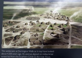
Remains of this little known dolmen are the most southerly in the departement of l'Aude
More Details: T4T35.fr
You may be viewing yesterday's version of this page. To see the most up to date information please register for a free account.
Do not use the above information on other web sites or publications without permission of the contributor.
Nearby Images from Flickr


The above images may not be of the site on this page, but were taken nearby. They are loaded from Flickr so please click on them for image credits.
Click here to see more info for this site
Nearby sites
Click here to view sites on an interactive map of the areaKey: Red: member's photo, Blue: 3rd party photo, Yellow: other image, Green: no photo - please go there and take one, Grey: site destroyed
Download sites to:
KML (Google Earth)
GPX (GPS waypoints)
CSV (Garmin/Navman)
CSV (Excel)
To unlock full downloads you need to sign up as a Contributory Member. Otherwise downloads are limited to 50 sites.
Turn off the page maps and other distractions
Nearby sites listing. In the following links * = Image available
11.5km SE 143° Dolmen de Bruga Burial Chamber or Dolmen
13.8km NNE 25° Grotte de la Cauna Cave or Rock Shelter
15.8km W 267° Menhir de Savignac-les-Ormeaux* Standing Stone (Menhir)
17.3km E 93° Grand Menhir de Counozouls* Standing Stone (Menhir)
18.3km W 275° La Cabane de Rolana* Burial Chamber or Dolmen
18.6km NNW 336° Source de Fontestorbes* Holy Well or Sacred Spring
20.3km ESE 105° Col de Jau menhir* Standing Stone (Menhir)
20.8km NW 316° Montségur museum* Museum
21.3km NW 317° Montségur* Ancient Village or Settlement
21.7km NW 323° Roc de Fougasse Natural Stone / Erratic / Other Natural Feature
22.5km NNW 345° Angauly Dolmen Burial Chamber or Dolmen
25.0km S 181° Dolmen de l'Arrel Burial Chamber or Dolmen
25.9km S 174° Menhir d'Odeillo* Standing Stone (Menhir)
26.2km S 179° Menhir d'Egat Standing Stone (Menhir)
26.4km S 179° Dolmen d'Egat Burial Chamber or Dolmen
26.9km S 184° Menhir n°2 de Targassonne* Standing Stone (Menhir)
26.9km S 184° Menhir Pedra dreta n°1 de Targassonne* Standing Stone (Menhir)
27.7km S 187° Tombe mégalithique des Fontetes* Chambered Tomb
28.4km S 171° Ciste n°1 Roca flavia* Cist
28.5km S 170° Dolmen de Pascarets* Burial Chamber or Dolmen
28.5km ESE 115° Dolmen du Roc de Jornac Burial Chamber or Dolmen
28.6km SSW 192° Dolmen de Dorres Burial Chamber or Dolmen
28.6km S 170° Cista del Molí* Burial Chamber or Dolmen
28.7km S 173° Ciste del Bac d'Amount* Chambered Tomb
28.7km SSE 167° Menhir du Col de la Perche* Standing Stone (Menhir)
View more nearby sites and additional images


 We would like to know more about this location. Please feel free to add a brief description and any relevant information in your own language.
 Wir möchten mehr über diese Stätte erfahren. Bitte zögern Sie nicht, eine kurze Beschreibung und relevante Informationen in Deutsch hinzuzufügen.
 Nous aimerions en savoir encore un peu sur les lieux. S'il vous plaît n'hesitez pas à ajouter une courte description et tous les renseignements pertinents dans votre propre langue.
 Quisieramos informarnos un poco más de las lugares. No dude en añadir una breve descripción y otros datos relevantes en su propio idioma.