


<< Our Photo Pages >> Pierre du Fouret - Standing Stone (Menhir) in France in Ile-de-France:Val-d'Oise (95)
Submitted by binardino on Thursday, 10 February 2005 Page Views: 4908
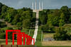
Neolithic and Bronze AgeSite Name: Pierre du Fouret Alternative Name: Palet de Gargantua, menhir de gencyCountry: France
NOTE: This site is 2.395 km away from the location you searched for.
Département: Ile-de-France:Val-d'Oise (95) Type: Standing Stone (Menhir)
Nearest Town: Pontoise Nearest Village: Cergy
Latitude: 49.042490N Longitude: 2.045487E
Condition:
| 5 | Perfect |
| 4 | Almost Perfect |
| 3 | Reasonable but with some damage |
| 2 | Ruined but still recognisable as an ancient site |
| 1 | Pretty much destroyed, possibly visible as crop marks |
| 0 | No data. |
| -1 | Completely destroyed |
| 5 | Superb |
| 4 | Good |
| 3 | Ordinary |
| 2 | Not Good |
| 1 | Awful |
| 0 | No data. |
| 5 | Can be driven to, probably with disabled access |
| 4 | Short walk on a footpath |
| 3 | Requiring a bit more of a walk |
| 2 | A long walk |
| 1 | In the middle of nowhere, a nightmare to find |
| 0 | No data. |
| 5 | co-ordinates taken by GPS or official recorded co-ordinates |
| 4 | co-ordinates scaled from a detailed map |
| 3 | co-ordinates scaled from a bad map |
| 2 | co-ordinates of the nearest village |
| 1 | co-ordinates of the nearest town |
| 0 | no data |
Internal Links:
External Links:
")
In profile, this menhir can look like a face.
Positional co-ordinates scaled from a map source.
Address: 57 rue de Vauréal, D922, 95000
Wikipedia article
Sites mégalithiques du Val-d'Oise
You may be viewing yesterday's version of this page. To see the most up to date information please register for a free account.
Do not use the above information on other web sites or publications without permission of the contributor.
Nearby Images from Flickr
![Belv�d�re Saint-Christophe [1985] - Cergy](https://farm66.static.flickr.com/65535/53600813109_eac8cde739_t.jpg)


The above images may not be of the site on this page, but were taken nearby. They are loaded from Flickr so please click on them for image credits.
Click here to see more info for this site
Nearby sites
Click here to view sites on an interactive map of the areaKey: Red: member's photo, Blue: 3rd party photo, Yellow: other image, Green: no photo - please go there and take one, Grey: site destroyed
Download sites to:
KML (Google Earth)
GPX (GPS waypoints)
CSV (Garmin/Navman)
CSV (Excel)
To unlock full downloads you need to sign up as a Contributory Member. Otherwise downloads are limited to 50 sites.
Turn off the page maps and other distractions
Nearby sites listing. In the following links * = Image available
1.8km SW 223° Cimetière des Anglais Allée couverte* Passage Grave
2.5km SSW 198° Menhir la Grande Pierre de Jouy* Standing Stone (Menhir)
4.1km ENE 77° Dampont Allée couverte* Passage Grave
5.4km NE 51° Menhir de la Haute Borne (Ennery)* Standing Stone (Menhir)
9.2km NE 44° Herouville Chateau Stones Ancient Village or Settlement
11.5km WSW 243° Allée Couverte des Mureaux* Passage Grave
11.5km WSW 243° Polissoir des Mureaux Polissoir
12.3km NNE 26° Allée couverte de la Chapelle* Passage Grave
12.5km ENE 70° L'Abbaye du Val Passage Grave
12.5km ENE 70° Dolmen le Mériel Passage Grave
14.1km ENE 56° Le Temple Passage Grave
14.4km NNE 22° Côte du Libéria* Passage Grave
14.4km NNE 22° Vigne des Grès Menhir* Standing Stone (Menhir)
14.5km WNW 293° Polissoir de St Martin* Polissoir
15.1km NE 47° Hypogée le Trou à Mort* Chambered Tomb
15.7km WNW 293° Menhir dit la Pierre Droite (Gadancourt)* Standing Stone (Menhir)
15.9km NE 42° Polissoir de la Forêt du Lay Polissoir
16.0km WNW 298° La Ferme Duport Passage Grave
16.0km WNW 297° Musée Archéologique Du Val-D'Oise* Museum
16.1km WNW 302° Menhir dit la Croisette* Standing Stone (Menhir)
16.5km SSE 167° Trou aux Anglais (Aubergenville)* Passage Grave
16.5km SSE 167° Conflans-Sainte-Honorine Allee-Couverte* Passage Grave
16.6km SSE 167° Musée D'Archeologie Nationale* Museum
16.7km WSW 236° Le Trou aux Anglais Passage Grave
16.9km W 268° La Cave aux Fées (Brueil-en-Vexin)* Passage Grave
View more nearby sites and additional images


 We would like to know more about this location. Please feel free to add a brief description and any relevant information in your own language.
 Wir möchten mehr über diese Stätte erfahren. Bitte zögern Sie nicht, eine kurze Beschreibung und relevante Informationen in Deutsch hinzuzufügen.
 Nous aimerions en savoir encore un peu sur les lieux. S'il vous plaît n'hesitez pas à ajouter une courte description et tous les renseignements pertinents dans votre propre langue.
 Quisieramos informarnos un poco más de las lugares. No dude en añadir una breve descripción y otros datos relevantes en su propio idioma.