


<< Our Photo Pages >> Érsekhalmi Földvár - Artificial Mound in Hungary
Submitted by Izozo on Sunday, 28 January 2024 Page Views: 104
Multi-periodSite Name: Érsekhalmi FöldvárCountry: Hungary
NOTE: This site is 51.79 km away from the location you searched for.
Type: Artificial Mound
Nearest Town: Érsekhalma Nearest Village: Érsekhalma
Latitude: 46.358954N Longitude: 19.108491E
Condition:
| 5 | Perfect |
| 4 | Almost Perfect |
| 3 | Reasonable but with some damage |
| 2 | Ruined but still recognisable as an ancient site |
| 1 | Pretty much destroyed, possibly visible as crop marks |
| 0 | No data. |
| -1 | Completely destroyed |
| 5 | Superb |
| 4 | Good |
| 3 | Ordinary |
| 2 | Not Good |
| 1 | Awful |
| 0 | No data. |
| 5 | Can be driven to, probably with disabled access |
| 4 | Short walk on a footpath |
| 3 | Requiring a bit more of a walk |
| 2 | A long walk |
| 1 | In the middle of nowhere, a nightmare to find |
| 0 | No data. |
| 5 | co-ordinates taken by GPS or official recorded co-ordinates |
| 4 | co-ordinates scaled from a detailed map |
| 3 | co-ordinates scaled from a bad map |
| 2 | co-ordinates of the nearest village |
| 1 | co-ordinates of the nearest town |
| 0 | no data |
Internal Links:
External Links:
")
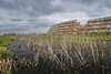
Can be reached from road 54, opposite to Érsekhalma, opposite to road 54118. Wooden steps to the top.
One of the most important Bronze Age ‘Vatya culture’ earthen castles, located on a steep loess bank, with one of the biggest diameter of 125 m (115 m at present). The Vatya culture is an archaeological culture of the Early to Middle Bronze Age (ca. 200 - 1400 BC) located in the central area of the Danube basin in Hungary. It is characterized mainly by fortified settlements, cremation burial sites and bronze production.
This place was called Vawantschana Bearg by the local germans (haunted hill). When the light of the full Moon just reaches the hill, its gate can be opened only with the hollowed out eyes of a six year old child, so the unbelivable treausure can be seen and taken. But be careful. When the Moon light passes by, the gate closes again. As until now nobody has sacrified a child the gate has never opened. This tale was collected by Mária Schőn from Ferencné Mendler in 1919. In 1959 Ferenc Deli, the local teacher reported the place to the National Museum.
You may be viewing yesterday's version of this page. To see the most up to date information please register for a free account.
")
")
Do not use the above information on other web sites or publications without permission of the contributor.
Nearby Images from Flickr
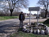
The above images may not be of the site on this page, but were taken nearby. They are loaded from Flickr so please click on them for image credits.
Click here to see more info for this site
Nearby sites
Click here to view sites on an interactive map of the areaKey: Red: member's photo, Blue: 3rd party photo, Yellow: other image, Green: no photo - please go there and take one, Grey: site destroyed
Download sites to:
KML (Google Earth)
GPX (GPS waypoints)
CSV (Garmin/Navman)
CSV (Excel)
To unlock full downloads you need to sign up as a Contributory Member. Otherwise downloads are limited to 50 sites.
Turn off the page maps and other distractions
Nearby sites listing. In the following links * = Image available
46.1km NNW 346° Bölcske-Vörösgyuru Tell Ancient Village or Settlement
65.2km NNW 343° Baracs-Földvar Tell Ancient Village or Settlement
66.1km N 350° Dunaujvaros-Koziderpadlas Tell Ancient Village or Settlement
89.9km NE 52° Tiszaug-Kemenyteto Tell Ancient Village or Settlement
90.9km NNE 32° Nagykőrös-Földvar Tell Ancient Village or Settlement
93.8km SSW 200° Osijek Ancient Village or Settlement
96.7km NNW 327° Gorsium Ancient Village or Settlement
102.6km NE 51° Nagyrev Zsidohalom Tell Ancient Village or Settlement
109.4km N 353° Százhalombatta Barrow Barrow Cemetery
109.5km N 353° Százhalombatta Tell* Ancient Village or Settlement
112.3km NE 44° Tószeg-Laposhalom Tell Ancient Village or Settlement
114.0km ENE 63° Gödény-halom* Ancient Village or Settlement
121.2km E 100° Bekai halom Ancient Village or Settlement
134.3km N 358° Aquincumi Museum Museum
146.2km E 98° Ziridava Ancient Village or Settlement
151.0km NNW 339° Vértesszőlősi Kő* Modern Stone Circle etc
152.7km NNE 26° Jaszdozsa-Kapolnahalom Tell Ancient Village or Settlement
155.4km NNW 338° Tatai Kő* Modern Stone Circle etc
155.5km ENE 76° Kevermesi sztélé* Standing Stones
158.0km SSW 213° Galovo Ancient Village or Settlement
166.5km ENE 75° Dobozi Kő* Modern Stone Circle etc
170.8km ESE 105° Cornesti-Iarcuri Bronze Age Fortification Misc. Earthwork
173.3km ENE 67° Veszto-Magor Tell Ancient Village or Settlement
175.2km ESE 117° Parta Neolithic Sanctuary* Ancient Temple
176.8km ESE 112° Museum of Banat Museum
View more nearby sites and additional images


 We would like to know more about this location. Please feel free to add a brief description and any relevant information in your own language.
 Wir möchten mehr über diese Stätte erfahren. Bitte zögern Sie nicht, eine kurze Beschreibung und relevante Informationen in Deutsch hinzuzufügen.
 Nous aimerions en savoir encore un peu sur les lieux. S'il vous plaît n'hesitez pas à ajouter une courte description et tous les renseignements pertinents dans votre propre langue.
 Quisieramos informarnos un poco más de las lugares. No dude en añadir una breve descripción y otros datos relevantes en su propio idioma.