


<< Our Photo Pages >> Grodzisko Stary Olkusz - Hillfort in Poland in Malopolskie
Submitted by SolarMegalith on Friday, 12 June 2020 Page Views: 645
Multi-periodSite Name: Grodzisko Stary OlkuszCountry: Poland
NOTE: This site is 9.119 km away from the location you searched for.
Voivodeship: Malopolskie Type: Hillfort
Nearest Town: Olkusz
Latitude: 50.286268N Longitude: 19.526916E
Condition:
| 5 | Perfect |
| 4 | Almost Perfect |
| 3 | Reasonable but with some damage |
| 2 | Ruined but still recognisable as an ancient site |
| 1 | Pretty much destroyed, possibly visible as crop marks |
| 0 | No data. |
| -1 | Completely destroyed |
| 5 | Superb |
| 4 | Good |
| 3 | Ordinary |
| 2 | Not Good |
| 1 | Awful |
| 0 | No data. |
| 5 | Can be driven to, probably with disabled access |
| 4 | Short walk on a footpath |
| 3 | Requiring a bit more of a walk |
| 2 | A long walk |
| 1 | In the middle of nowhere, a nightmare to find |
| 0 | No data. |
| 5 | co-ordinates taken by GPS or official recorded co-ordinates |
| 4 | co-ordinates scaled from a detailed map |
| 3 | co-ordinates scaled from a bad map |
| 2 | co-ordinates of the nearest village |
| 1 | co-ordinates of the nearest town |
| 0 | no data |
Internal Links:
External Links:
I have visited· I would like to visit
SolarMegalith visited on 23rd May 2020 - their rating: Cond: 4 Amb: 3 Access: 4
")
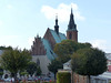
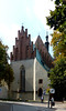
A well-preserved medieval hillfort with an impressive rampart, ditch and outer bank is located west of the town of Olkusz. The earthworks survived in good condition, especially in western and southern part of the hillfort. In 15th-16th century a church of St. John the Baptist was built within the site of the abandoned hillfort, it survived as a ruin.
Reference:
Sypek R. (2001). Zamki i obiekty warowne Jury Krakowsko-Częstochowskiej. Warszawa: Agencja Wydawnicza CB.
You may be viewing yesterday's version of this page. To see the most up to date information please register for a free account.
")
")
")
Do not use the above information on other web sites or publications without permission of the contributor.
Nearby Images from Flickr
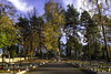
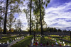
The above images may not be of the site on this page, but were taken nearby. They are loaded from Flickr so please click on them for image credits.
Click here to see more info for this site
Nearby sites
Click here to view sites on an interactive map of the areaKey: Red: member's photo, Blue: 3rd party photo, Yellow: other image, Green: no photo - please go there and take one, Grey: site destroyed
Download sites to:
KML (Google Earth)
GPX (GPS waypoints)
CSV (Garmin/Navman)
CSV (Excel)
To unlock full downloads you need to sign up as a Contributory Member. Otherwise downloads are limited to 50 sites.
Turn off the page maps and other distractions
Nearby sites listing. In the following links * = Image available
17.1km SSE 155° Grodzisko Bartlowa Góra - Czatkowice Hillfort
18.4km NNE 32° Jaskinia Na Biśniku Cave or Rock Shelter
19.9km NNE 32° Smoleń - Zamek Pilcza* Ancient Village or Settlement
19.9km SE 130° Grodzisko Będkowice* Hillfort
23.5km ESE 122° Jaskinia Wierzchowska Górna* Cave or Rock Shelter
23.6km ESE 123° Jaskinia Mamutowa* Cave or Rock Shelter
24.5km NE 44° Grodzisko Udórz Hillfort
28.9km N 1° Jaskinia w Dziadowej Skale Cave or Rock Shelter
29.0km SSE 152° Grodzisko Mników Hillfort
34.0km N 5° Grodzisko Góra Słupsko* Hillfort
35.5km SSE 158° Wołowice Flint Mine Ancient Mine, Quarry or other Industry
38.7km SE 131° Archaeological Museum of Kraków* Museum
38.9km SE 131° Kraków - Wawel* Ancient Village or Settlement
41.3km SE 132° Kopiec Krakusa* Artificial Mound
45.4km ESE 122° Kopiec Wandy* Artificial Mound
45.8km N 350° Grodzisko Wały - Potok Złoty* Hillfort
48.3km S 182° Grodzisko Gorzeń Górny* Hillfort
48.9km S 169° Grodzisko Bugaj* Hillfort
52.3km NNW 342° Jaskinia Komarowa Cave or Rock Shelter
56.1km E 88° Kurhan Pałecznica Round Barrow(s)
56.4km NNW 341° Jaskinia Towarna Cave or Rock Shelter
57.6km S 175° Grodzisko Zembrzyce* Promontory Fort / Cliff Castle
57.8km E 83° Kurhan Szczotkowice Round Barrow(s)
59.9km SE 128° Kurhany Jawczyce Barrow Cemetery
60.3km S 175° Muzeum Miejskie Suchej Beskidzkiej* Museum
View more nearby sites and additional images


 We would like to know more about this location. Please feel free to add a brief description and any relevant information in your own language.
 Wir möchten mehr über diese Stätte erfahren. Bitte zögern Sie nicht, eine kurze Beschreibung und relevante Informationen in Deutsch hinzuzufügen.
 Nous aimerions en savoir encore un peu sur les lieux. S'il vous plaît n'hesitez pas à ajouter une courte description et tous les renseignements pertinents dans votre propre langue.
 Quisieramos informarnos un poco más de las lugares. No dude en añadir una breve descripción y otros datos relevantes en su propio idioma.