

<< Our Photo Pages >> Lauterhorn - Natural Stone / Erratic / Other Natural Feature in Sweden in Gotland
Submitted by Bjorn on Monday, 04 June 2007 Page Views: 5204
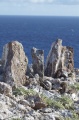
Natural PlacesSite Name: LauterhornCountry: Sweden
NOTE: This site is 4.799 km away from the location you searched for.
Landskap: Gotland Type: Natural Stone / Erratic / Other Natural Feature
Latitude: 57.953000N Longitude: 19.077200E
Condition:
| 5 | Perfect |
| 4 | Almost Perfect |
| 3 | Reasonable but with some damage |
| 2 | Ruined but still recognisable as an ancient site |
| 1 | Pretty much destroyed, possibly visible as crop marks |
| 0 | No data. |
| -1 | Completely destroyed |
| 5 | Superb |
| 4 | Good |
| 3 | Ordinary |
| 2 | Not Good |
| 1 | Awful |
| 0 | No data. |
| 5 | Can be driven to, probably with disabled access |
| 4 | Short walk on a footpath |
| 3 | Requiring a bit more of a walk |
| 2 | A long walk |
| 1 | In the middle of nowhere, a nightmare to find |
| 0 | No data. |
| 5 | co-ordinates taken by GPS or official recorded co-ordinates |
| 4 | co-ordinates scaled from a detailed map |
| 3 | co-ordinates scaled from a bad map |
| 2 | co-ordinates of the nearest village |
| 1 | co-ordinates of the nearest town |
| 0 | no data |
Internal Links:
External Links:
I have visited· I would like to visit
43559959 visited on 10th Jul 2014 - their rating: Cond: 4 Amb: 4 Access: 4
Bjorn have visited here
")
Since the inland ice cleared the area over 10,000 years ago these lime stone rocks have been eroded by water and wind. In Gotland there are 25 of these rauk areas.
You may be viewing yesterday's version of this page. To see the most up to date information please register for a free account.
")
")
")
")
")
")
")
Do not use the above information on other web sites or publications without permission of the contributor.
Click here to see more info for this site
Nearby sites
Click here to view sites on an interactive map of the areaKey: Red: member's photo, Blue: 3rd party photo, Yellow: other image, Green: no photo - please go there and take one, Grey: site destroyed
Download sites to:
KML (Google Earth)
GPX (GPS waypoints)
CSV (Garmin/Navman)
CSV (Excel)
To unlock full downloads you need to sign up as a Contributory Member. Otherwise downloads are limited to 50 sites.
Turn off the page maps and other distractions
Nearby sites listing. In the following links * = Image available
2.3km ENE 70° Lauter (Fårö)* Stone Circle
3.8km NNE 32° Digerhuvud* Natural Stone / Erratic / Other Natural Feature
8.2km NE 50° Langhammars* Natural Stone / Erratic / Other Natural Feature
11.4km SSW 195° Bunge Museet Museum
11.4km SSW 196° Bunge Trojaborg Turf Maze
18.5km SSW 197° Lergravsporten* Natural Stone / Erratic / Other Natural Feature
22.3km SSW 213° Lilla Ihre Gravfält Barrow Cemetery
22.9km SW 224° Kauparve röse* Cairn
24.1km WSW 244° Hangvar 34:1 Barrow Cemetery
24.3km SW 219° Domarlunden* Stone Circle
24.3km SW 220° Lajkarhajd* Cairn
24.6km SW 220° Sangelstainen* Natural Stone / Erratic / Other Natural Feature
24.9km SW 222° Lärbro Kyrka Bildsten* Sculptured Stone
25.2km SW 216° Pavals* Stone Circle
26.5km SW 234° Tänselgårde* Stone Circle
27.5km SW 218° Stora Bjärs* Chambered Cairn
29.5km SW 216° Stenstugu* Stone Circle
35.8km SW 223° Filehajdars* Standing Stones
35.9km SW 223° Tiselhagens* Stone Circle
36.1km SSW 210° Klinteklinten* Natural Stone / Erratic / Other Natural Feature
36.5km WSW 240° Lilla Bjärs Gravfält* Barrow Cemetery
36.9km WSW 242° Hjulkorsgraven* Chambered Cairn
38.9km SW 223° Bjärs Gravfält (Hejnum) Barrow Cemetery
41.2km SSW 209° Gothem 232:1* Hillfort
41.4km SSW 210° Boge 33:1* Barrow Cemetery
View more nearby sites and additional images


 We would like to know more about this location. Please feel free to add a brief description and any relevant information in your own language.
 Wir möchten mehr über diese Stätte erfahren. Bitte zögern Sie nicht, eine kurze Beschreibung und relevante Informationen in Deutsch hinzuzufügen.
 Nous aimerions en savoir encore un peu sur les lieux. S'il vous plaît n'hesitez pas à ajouter une courte description et tous les renseignements pertinents dans votre propre langue.
 Quisieramos informarnos un poco más de las lugares. No dude en añadir una breve descripción y otros datos relevantes en su propio idioma.