

<< Our Photo Pages >> Palenica Earthwork - Misc. Earthwork in Poland in Slaskie
Submitted by SolarMegalith on Wednesday, 17 November 2010 Page Views: 2954
Multi-periodSite Name: Palenica EarthworkCountry: Poland
NOTE: This site is 7.598 km away from the location you searched for.
Voivodeship: Slaskie Type: Misc. Earthwork
Nearest Town: Bielsko-Biała Nearest Village: Jaworze
Latitude: 49.779050N Longitude: 18.962230E
Condition:
| 5 | Perfect |
| 4 | Almost Perfect |
| 3 | Reasonable but with some damage |
| 2 | Ruined but still recognisable as an ancient site |
| 1 | Pretty much destroyed, possibly visible as crop marks |
| 0 | No data. |
| -1 | Completely destroyed |
| 5 | Superb |
| 4 | Good |
| 3 | Ordinary |
| 2 | Not Good |
| 1 | Awful |
| 0 | No data. |
| 5 | Can be driven to, probably with disabled access |
| 4 | Short walk on a footpath |
| 3 | Requiring a bit more of a walk |
| 2 | A long walk |
| 1 | In the middle of nowhere, a nightmare to find |
| 0 | No data. |
| 5 | co-ordinates taken by GPS or official recorded co-ordinates |
| 4 | co-ordinates scaled from a detailed map |
| 3 | co-ordinates scaled from a bad map |
| 2 | co-ordinates of the nearest village |
| 1 | co-ordinates of the nearest town |
| 0 | no data |
Internal Links:
External Links:
")
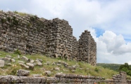
Ring of earthwork located on top of Palenica mountain was a sacred place for local Slavic tribes in early medieval period. The bank consists of earth and stones and is surrounded with a ditch. Inside the earthwork small stone mounds were discovered, but the excavations did not reveal any trances of burials inside them, just thick layer of charcoal.
Access to Palenica is quite difficult, the trail is climbing sharply, but well-preserved sacred place of Slavs is worth visiting.
You may be viewing yesterday's version of this page. To see the most up to date information please register for a free account.
")
Do not use the above information on other web sites or publications without permission of the contributor.
Nearby Images from Flickr


The above images may not be of the site on this page, but were taken nearby. They are loaded from Flickr so please click on them for image credits.
Click here to see more info for this site
Nearby sites
Click here to view sites on an interactive map of the areaKey: Red: member's photo, Blue: 3rd party photo, Yellow: other image, Green: no photo - please go there and take one, Grey: site destroyed
Download sites to:
KML (Google Earth)
GPX (GPS waypoints)
CSV (Garmin/Navman)
CSV (Excel)
To unlock full downloads you need to sign up as a Contributory Member. Otherwise downloads are limited to 50 sites.
Turn off the page maps and other distractions
Nearby sites listing. In the following links * = Image available
1.4km NNW 334° Grodzisko Zómczysko* Ancient Village or Settlement
3.1km NW 325° Młyńska Kępa Settlement* Ancient Village or Settlement
6.5km NE 40° Grodzisko Stare Bielsko* Hillfort
13.6km W 274° Grodzisko Międzyświeć* Hillfort
16.2km WSW 246° Machulowa Settlement* Ancient Village or Settlement
16.6km WSW 241° Góra Grodzisko Settlement* Ancient Village or Settlement
18.2km WSW 241° Góra Tuł Settlement* Ancient Village or Settlement
19.0km SW 233° Góra Ostry Settlement* Ancient Village or Settlement
22.6km WSW 248° Puńców Settlement* Ancient Village or Settlement
24.3km W 263° Grodzisko Góra Zamkowa - Cieszyn* Hillfort
28.9km ESE 108° Grodzisko Gilowice* Hillfort
40.0km ENE 78° Grodzisko Gorzeń Górny* Hillfort
45.2km E 91° Grodzisko Zembrzyce* Promontory Fort / Cliff Castle
46.1km E 94° Muzeum Miejskie Suchej Beskidzkiej* Museum
50.4km E 80° Grodzisko Bugaj* Hillfort
58.9km ENE 66° Wołowice Flint Mine Ancient Mine, Quarry or other Industry
59.8km W 275° Selebice Menhir Standing Stone (Menhir)
62.3km ENE 60° Grodzisko Mników Hillfort
62.9km NE 49° Grodzisko Bartlowa Góra - Czatkowice Hillfort
63.0km NNW 332° Kurhan Łany Wielkie* Round Barrow(s)
63.8km WNW 304° Muzeum w Raciborzu* Museum
69.3km NE 35° Grodzisko Stary Olkusz* Hillfort
70.9km NE 52° Grodzisko Będkowice* Hillfort
72.9km WSW 239° Vidče Stone Spheres* Natural Stone / Erratic / Other Natural Feature
74.5km NE 54° Jaskinia Mamutowa* Cave or Rock Shelter
View more nearby sites and additional images


 We would like to know more about this location. Please feel free to add a brief description and any relevant information in your own language.
 Wir möchten mehr über diese Stätte erfahren. Bitte zögern Sie nicht, eine kurze Beschreibung und relevante Informationen in Deutsch hinzuzufügen.
 Nous aimerions en savoir encore un peu sur les lieux. S'il vous plaît n'hesitez pas à ajouter une courte description et tous les renseignements pertinents dans votre propre langue.
 Quisieramos informarnos un poco más de las lugares. No dude en añadir una breve descripción y otros datos relevantes en su propio idioma.