


<< Our Photo Pages >> Grodzisko Góra Zamkowa - Cieszyn - Hillfort in Poland in Slaskie
Submitted by SolarMegalith on Tuesday, 09 August 2011 Page Views: 4327
Iron Age and Later PrehistorySite Name: Grodzisko Góra Zamkowa - Cieszyn Alternative Name: Wzgórze ZamkoweCountry: Poland
NOTE: This site is 24.037 km away from the location you searched for.
Voivodeship: Slaskie Type: Hillfort
Nearest Town: Cieszyn
Latitude: 49.751389N Longitude: 18.626111E
Condition:
| 5 | Perfect |
| 4 | Almost Perfect |
| 3 | Reasonable but with some damage |
| 2 | Ruined but still recognisable as an ancient site |
| 1 | Pretty much destroyed, possibly visible as crop marks |
| 0 | No data. |
| -1 | Completely destroyed |
| 5 | Superb |
| 4 | Good |
| 3 | Ordinary |
| 2 | Not Good |
| 1 | Awful |
| 0 | No data. |
| 5 | Can be driven to, probably with disabled access |
| 4 | Short walk on a footpath |
| 3 | Requiring a bit more of a walk |
| 2 | A long walk |
| 1 | In the middle of nowhere, a nightmare to find |
| 0 | No data. |
| 5 | co-ordinates taken by GPS or official recorded co-ordinates |
| 4 | co-ordinates scaled from a detailed map |
| 3 | co-ordinates scaled from a bad map |
| 2 | co-ordinates of the nearest village |
| 1 | co-ordinates of the nearest town |
| 0 | no data |
Internal Links:
External Links:
I have visited· I would like to visit
SolarMegalith visited on 6th Aug 2011 - their rating: Cond: 1 Amb: 3 Access: 4
")
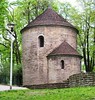
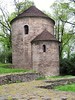
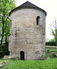
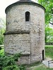
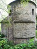
The earliest finds from Góra Zamkowa (Castle Hill) in Cieszyn are dated for the Neolithic period. Materials of Lusatian culture (Early Iron Age) and Puchov culture (La Tene period) were discovered beneath the earthworks of the early medieval (9th-10th century) hillfort. In 1374 prince Przemysław I Noszak started construction of a stone castle here, remains of which are visible till nowadays.
You may be viewing yesterday's version of this page. To see the most up to date information please register for a free account.
")
Do not use the above information on other web sites or publications without permission of the contributor.
Nearby Images from Flickr

The above images may not be of the site on this page, but were taken nearby. They are loaded from Flickr so please click on them for image credits.
Click here to see more info for this site
Nearby sites
Click here to view sites on an interactive map of the areaKey: Red: member's photo, Blue: 3rd party photo, Yellow: other image, Green: no photo - please go there and take one, Grey: site destroyed
Download sites to:
KML (Google Earth)
GPX (GPS waypoints)
CSV (Garmin/Navman)
CSV (Excel)
To unlock full downloads you need to sign up as a Contributory Member. Otherwise downloads are limited to 50 sites.
Turn off the page maps and other distractions
Nearby sites listing. In the following links * = Image available
6.1km SSE 149° Puńców Settlement* Ancient Village or Settlement
9.9km ESE 110° Machulowa Settlement* Ancient Village or Settlement
10.2km SE 125° Góra Tuł Settlement* Ancient Village or Settlement
10.8km ESE 117° Góra Grodzisko Settlement* Ancient Village or Settlement
11.3km ENE 69° Grodzisko Międzyświeć* Hillfort
12.2km SE 133° Góra Ostry Settlement* Ancient Village or Settlement
23.1km ENE 76° Młyńska Kępa Settlement* Ancient Village or Settlement
23.9km E 79° Grodzisko Zómczysko* Ancient Village or Settlement
24.3km E 83° Palenica Earthwork* Misc. Earthwork
29.4km ENE 74° Grodzisko Stare Bielsko* Hillfort
36.4km WNW 283° Selebice Menhir Standing Stone (Menhir)
48.0km NW 323° Muzeum w Raciborzu* Museum
51.5km SW 228° Vidče Stone Spheres* Natural Stone / Erratic / Other Natural Feature
51.9km E 96° Grodzisko Gilowice* Hillfort
58.9km N 354° Kurhan Łany Wielkie* Round Barrow(s)
61.6km NW 323° Grodzisko Dzielawy Hillfort
64.2km E 80° Grodzisko Gorzeń Górny* Hillfort
69.3km E 88° Grodzisko Zembrzyce* Promontory Fort / Cliff Castle
70.1km E 90° Muzeum Miejskie Suchej Beskidzkiej* Museum
74.8km E 81° Grodzisko Bugaj* Hillfort
78.6km NW 322° Grodzisko Naczęsławice Hillfort
82.5km ENE 71° Wołowice Flint Mine Ancient Mine, Quarry or other Industry
84.2km ENE 58° Grodzisko Bartlowa Góra - Czatkowice Hillfort
85.3km ENE 66° Grodzisko Mników Hillfort
87.6km NE 47° Grodzisko Stary Olkusz* Hillfort
View more nearby sites and additional images

")
 We would like to know more about this location. Please feel free to add a brief description and any relevant information in your own language.
 Wir möchten mehr über diese Stätte erfahren. Bitte zögern Sie nicht, eine kurze Beschreibung und relevante Informationen in Deutsch hinzuzufügen.
 Nous aimerions en savoir encore un peu sur les lieux. S'il vous plaît n'hesitez pas à ajouter une courte description et tous les renseignements pertinents dans votre propre langue.
 Quisieramos informarnos un poco más de las lugares. No dude en añadir una breve descripción y otros datos relevantes en su propio idioma.