


<< Our Photo Pages >> Runriket - Standing Stones in Sweden in Uppland
Submitted by meginring on Wednesday, 20 August 2008 Page Views: 5710
Neolithic and Bronze AgeSite Name: Runriket Alternative Name: Jarlabankes bro, The Kingdom of RunesCountry: Sweden Landskap: Uppland Type: Standing Stones
Nearest Town: Täby Nearest Village: Täby kyrkby
Latitude: 59.499060N Longitude: 18.063180E
Condition:
| 5 | Perfect |
| 4 | Almost Perfect |
| 3 | Reasonable but with some damage |
| 2 | Ruined but still recognisable as an ancient site |
| 1 | Pretty much destroyed, possibly visible as crop marks |
| 0 | No data. |
| -1 | Completely destroyed |
| 5 | Superb |
| 4 | Good |
| 3 | Ordinary |
| 2 | Not Good |
| 1 | Awful |
| 0 | No data. |
| 5 | Can be driven to, probably with disabled access |
| 4 | Short walk on a footpath |
| 3 | Requiring a bit more of a walk |
| 2 | A long walk |
| 1 | In the middle of nowhere, a nightmare to find |
| 0 | No data. |
| 5 | co-ordinates taken by GPS or official recorded co-ordinates |
| 4 | co-ordinates scaled from a detailed map |
| 3 | co-ordinates scaled from a bad map |
| 2 | co-ordinates of the nearest village |
| 1 | co-ordinates of the nearest town |
| 0 | no data |
Internal Links:
External Links:
")
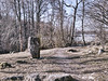
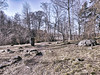
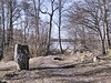
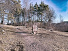
Runriket – The Kingdom of Runes
The suburb Täby just north of Stockholm and the adjacent Vallentuna, has the largest collection of rune stones in the world.
Täby kommun (municipality) has managed to restore the one thousand year old Jarlabankes bro (Jarlabanke’s Bridge), to what it is known to have looked like in the 18th century.
Jarlabankes bro is a causeway for public use which now also marks the beginning of "Runriket" ("The Kingdom of Runes"). This is a never closing open-air museum and history trail, vividly depicting the breaking-point between the "heathen" period and Christianity in Scandinavia.
Lit up at night, it also has signs with explanations and translations in English.
http://www.taby.se/templates/TswComplexPage.aspx?id=2608
Don’t miss out the nearby early medieval Täby kyrka (church) in Täby kyrkby (church village).
For more rune stones in "Runriket", check out the post "Täby" submitted by greyweather
You may be viewing yesterday's version of this page. To see the most up to date information please register for a free account.
")
")
")
Do not use the above information on other web sites or publications without permission of the contributor.
Nearby Images from Flickr


The above images may not be of the site on this page, but were taken nearby. They are loaded from Flickr so please click on them for image credits.
Click here to see more info for this site
Nearby sites
Click here to view sites on an interactive map of the areaKey: Red: member's photo, Blue: 3rd party photo, Yellow: other image, Green: no photo - please go there and take one, Grey: site destroyed
Download sites to:
KML (Google Earth)
GPX (GPS waypoints)
CSV (Garmin/Navman)
CSV (Excel)
To unlock full downloads you need to sign up as a Contributory Member. Otherwise downloads are limited to 50 sites.
Turn off the page maps and other distractions
Nearby sites listing. In the following links * = Image available
3.6km SW 222° Täby* Carving
7.9km NE 50° Örsta hällristning* Rock Art
9.0km W 280° Hammarby 154:1* Sculptured Stone
9.8km WNW 282° Zamores kulle* Barrow Cemetery
10.3km W 280° Smedby* Sculptured Stone
13.5km NW 320° Nordians hög* Barrow Cemetery
14.9km WNW 299° Runsa (Upplands-Väsby)* Stone Circle
16.9km SE 127° U 170 (Vaxholm)* Carving
17.9km NNW 335° Arlanda Mäby Rune Stone* Carving
18.8km S 175° Historiska Museet* Museum
18.9km S 179° Medelhavsmuseet Museum Museum
19.1km SSW 209° Björklunds hage* Barrow Cemetery
19.2km S 177° Museum of Far Eastern Antiquities* Museum
19.4km S 179° Gamla stans runsten* Carving
23.3km NW 304° Sigtuna U 389* Sculptured Stone
23.3km NW 304° Sigtuna U Fv1958 250* Sculptured Stone
23.4km NW 304° Sigtuna U 390* Sculptured Stone
25.2km W 273° Upplands-Bro* Carving
27.2km SSW 200° Skärholmen Domarringen* Stone Circle
28.1km WSW 236° Sånga 70:1 Cairn
28.5km W 273° Rösaring* Carving
28.8km WSW 258° Vallbyåsen* Standing Stones
30.1km SSW 204° Slagsta Hällristning* Rock Art
31.3km SW 223° Nyckelby* Standing Stone (Menhir)
33.8km WSW 243° Skopintull* Round Barrow(s)
View more nearby sites and additional images


 We would like to know more about this location. Please feel free to add a brief description and any relevant information in your own language.
 Wir möchten mehr über diese Stätte erfahren. Bitte zögern Sie nicht, eine kurze Beschreibung und relevante Informationen in Deutsch hinzuzufügen.
 Nous aimerions en savoir encore un peu sur les lieux. S'il vous plaît n'hesitez pas à ajouter une courte description et tous les renseignements pertinents dans votre propre langue.
 Quisieramos informarnos un poco más de las lugares. No dude en añadir una breve descripción y otros datos relevantes en su propio idioma.