


<< Our Photo Pages >> Xrobb l-Għaġin Temple - Ancient Temple in Malta in Mainland
Submitted by KaiHofmann on Thursday, 16 February 2023 Page Views: 339
Neolithic and Bronze AgeSite Name: Xrobb l-Għaġin TempleCountry: Malta
NOTE: This site is 324.78 km away from the location you searched for.
Island: Mainland Type: Ancient Temple
Nearest Town: Marsaxlokk
Latitude: 35.843801N Longitude: 14.568455E
Condition:
| 5 | Perfect |
| 4 | Almost Perfect |
| 3 | Reasonable but with some damage |
| 2 | Ruined but still recognisable as an ancient site |
| 1 | Pretty much destroyed, possibly visible as crop marks |
| 0 | No data. |
| -1 | Completely destroyed |
| 5 | Superb |
| 4 | Good |
| 3 | Ordinary |
| 2 | Not Good |
| 1 | Awful |
| 0 | No data. |
| 5 | Can be driven to, probably with disabled access |
| 4 | Short walk on a footpath |
| 3 | Requiring a bit more of a walk |
| 2 | A long walk |
| 1 | In the middle of nowhere, a nightmare to find |
| 0 | No data. |
| 5 | co-ordinates taken by GPS or official recorded co-ordinates |
| 4 | co-ordinates scaled from a detailed map |
| 3 | co-ordinates scaled from a bad map |
| 2 | co-ordinates of the nearest village |
| 1 | co-ordinates of the nearest town |
| 0 | no data |
Internal Links:
External Links:
")
Ruined neolithic temple of the Ġgantija phase. Today with disabled access. Probably some of the megaliths are still to see.
You may be viewing yesterday's version of this page. To see the most up to date information please register for a free account.
Do not use the above information on other web sites or publications without permission of the contributor.
Nearby Images from Flickr
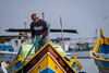
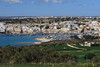
The above images may not be of the site on this page, but were taken nearby. They are loaded from Flickr so please click on them for image credits.
Click here to see more info for this site
Nearby sites
Click here to view sites on an interactive map of the areaKey: Red: member's photo, Blue: 3rd party photo, Yellow: other image, Green: no photo - please go there and take one, Grey: site destroyed
Download sites to:
KML (Google Earth)
GPX (GPS waypoints)
CSV (Garmin/Navman)
CSV (Excel)
To unlock full downloads you need to sign up as a Contributory Member. Otherwise downloads are limited to 50 sites.
Turn off the page maps and other distractions
Nearby sites listing. In the following links * = Image available
1.5km W 279° Tas-Silg* Ancient Temple
2.0km WNW 285° Hal Ginwi temple Ancient Temple
2.9km NNW 335° Il-Bidni* Burial Chamber or Dolmen
3.7km WSW 248° St George's Bay Cart Ruts* Ancient Trackway
3.7km WSW 248° St George's Bay Silos* Ancient Mine, Quarry or other Industry
3.7km WSW 257° Ghar Dalam Cart Ruts* Ancient Trackway
3.8km WSW 257° Ghar Dalam Cave* Cave or Rock Shelter
3.8km WSW 249° Borg in-Nadur Temple* Ancient Temple
3.9km WSW 250° Borg in-Nadur Settlement* Ancient Village or Settlement
3.9km WSW 252° Borg in-Nadur Cart Ruts* Ancient Trackway
5.8km NNW 326° il-Kalkara Cart Ruts* Ancient Trackway
5.8km WNW 299° Tarxien* Ancient Temple
6.3km WNW 297° Hal Saflieni Hypogeum* Ancient Temple
6.3km SW 235° Wied Znuber* Burial Chamber or Dolmen
6.5km NW 305° Kordin III* Ancient Temple
7.8km W 274° Is-Salib* Standing Stone (Menhir)
7.9km NW 319° The Malta National Museum of Archaeology* Museum
10.3km WNW 298° Ta' Raddiena* Ancient Temple
10.6km W 269° Misrah is-Sinjura* Burial Chamber or Dolmen
11.1km NW 313° Tal-Mensija Cart Tracks San Gwann* Ancient Trackway
11.5km W 261° Hagar Qim* Ancient Temple
12.1km W 261° Mnajdra* Ancient Temple
12.1km W 262° Misqa Tanks* NOT SET
14.5km WNW 303° Tal-Wej Cart Ruts* Ancient Trackway
14.7km NW 308° Triq il-Fortizza tal-Mosta Cart Ruts* Ancient Trackway
View more nearby sites and additional images


 We would like to know more about this location. Please feel free to add a brief description and any relevant information in your own language.
 Wir möchten mehr über diese Stätte erfahren. Bitte zögern Sie nicht, eine kurze Beschreibung und relevante Informationen in Deutsch hinzuzufügen.
 Nous aimerions en savoir encore un peu sur les lieux. S'il vous plaît n'hesitez pas à ajouter une courte description et tous les renseignements pertinents dans votre propre langue.
 Quisieramos informarnos un poco más de las lugares. No dude en añadir una breve descripción y otros datos relevantes en su propio idioma.