


<< Our Photo Pages >> Te Waikoropupu Springs - Holy Well or Sacred Spring in New Zealand
Submitted by KiwiBetsy on Monday, 20 June 2005 Page Views: 11557
Springs and Holy WellsSite Name: Te Waikoropupu Springs Alternative Name: Pupu SpringsCountry: New Zealand
NOTE: This site is 2.587 km away from the location you searched for.
Type: Holy Well or Sacred Spring
Nearest Town: Takaka Nearest Village: Takaka
Latitude: 40.8477S Longitude: 172.769400E
Condition:
| 5 | Perfect |
| 4 | Almost Perfect |
| 3 | Reasonable but with some damage |
| 2 | Ruined but still recognisable as an ancient site |
| 1 | Pretty much destroyed, possibly visible as crop marks |
| 0 | No data. |
| -1 | Completely destroyed |
| 5 | Superb |
| 4 | Good |
| 3 | Ordinary |
| 2 | Not Good |
| 1 | Awful |
| 0 | No data. |
| 5 | Can be driven to, probably with disabled access |
| 4 | Short walk on a footpath |
| 3 | Requiring a bit more of a walk |
| 2 | A long walk |
| 1 | In the middle of nowhere, a nightmare to find |
| 0 | No data. |
| 5 | co-ordinates taken by GPS or official recorded co-ordinates |
| 4 | co-ordinates scaled from a detailed map |
| 3 | co-ordinates scaled from a bad map |
| 2 | co-ordinates of the nearest village |
| 1 | co-ordinates of the nearest town |
| 0 | no data |
Internal Links:
External Links:
I have visited· I would like to visit
Klingon visited - their rating: Cond: 5 Amb: 4 Access: 5
")
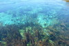
The water bursts forth at around 40 bathtubs per second after percolating through a network of natural marble lined channels under the Takaka Hills.
A mirrored viewing platform, rather like a periscope in reverse, allows one to view the rich variety of plant life that enjoys the upthrust pure water.
Note: The Portal has arrived in New Zealand, try the Multimap link, it really works!
You may be viewing yesterday's version of this page. To see the most up to date information please register for a free account.
")
")
")
Do not use the above information on other web sites or publications without permission of the contributor.
Nearby Images from Flickr
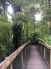
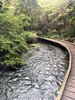
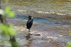
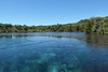
The above images may not be of the site on this page, but were taken nearby. They are loaded from Flickr so please click on them for image credits.
Click here to see more info for this site
Nearby sites
Click here to view sites on an interactive map of the areaKey: Red: member's photo, Blue: 3rd party photo, Yellow: other image, Green: no photo - please go there and take one, Grey: site destroyed
Download sites to:
KML (Google Earth)
GPX (GPS waypoints)
CSV (Garmin/Navman)
CSV (Excel)
To unlock full downloads you need to sign up as a Contributory Member. Otherwise downloads are limited to 50 sites.
Turn off the page maps and other distractions
Nearby sites listing. In the following links * = Image available
57.5km WSW 254° Whakapoāi* Ancient Village or Settlement
192.2km NE 43° Te Uma a Tongahake Pa* Hillfort
192.4km NE 43° Turuturu Mokai Pa* Hillfort
193.4km NE 43° Tawhiti Museum* Museum
224.7km NNE 29° Whakawhitiwhiti Pā* Hillfort
228.0km NNE 30° Te Punga a Matori* Sculptured Stone
233.4km SW 215° Taramakau Pa* Ancient Village or Settlement
237.4km E 98° Stonehenge Aotearoa* Modern Stone Circle etc
244.2km E 91° Wairarapa Stone Circle Modern Stone Circle etc
298.6km S 182° Canterbury Museum* Museum
306.4km S 181° Ōhinehou* Ancient Village or Settlement
319.1km S 176° Okains Bay Maori and Colonial Museum* Museum
369.8km NNE 28° Ruapuke Pa* Standing Stone (Menhir)
388.5km NE 47° Pohaturoa* Hillfort
467.1km NNE 23° Mangere Mountain Pa* Hillfort
469.5km NNE 22° Puketapapa Pa* Hillfort
470.8km NNE 23° Otahuhu Pa* Hillfort
472.3km NNE 22° Maungakiekie Pa* Hillfort
472.8km NNE 22° Cornwall Park Rongo Stone* Standing Stone (Menhir)
473.3km NNE 22° Epsom Modern Megalith* Modern Stone Circle etc
473.9km NNE 22° Te Kopuke Pa* Hillfort
474.0km NNE 22° Maungawhau* Hillfort
474.7km NNE 22° Remuera Pa* Hillfort
474.9km NNE 23° Maungarei Stonefields* Ancient Village or Settlement
475.2km NNE 23° Maungarei Pa* Hillfort
View more nearby sites and additional images


 We would like to know more about this location. Please feel free to add a brief description and any relevant information in your own language.
 Wir möchten mehr über diese Stätte erfahren. Bitte zögern Sie nicht, eine kurze Beschreibung und relevante Informationen in Deutsch hinzuzufügen.
 Nous aimerions en savoir encore un peu sur les lieux. S'il vous plaît n'hesitez pas à ajouter une courte description et tous les renseignements pertinents dans votre propre langue.
 Quisieramos informarnos un poco más de las lugares. No dude en añadir una breve descripción y otros datos relevantes en su propio idioma.