


<< Our Photo Pages >> Pyramid of Dragon - Natural Stone / Erratic / Other Natural Feature in Bosnia
Submitted by Klingon on Friday, 15 September 2006 Page Views: 4732
Natural PlacesSite Name: Pyramid of DragonCountry: Bosnia
NOTE: This site is 30.287 km away from the location you searched for.
Type: Natural Stone / Erratic / Other Natural Feature
Nearest Town: Sarejevo Nearest Village: Visoko
Latitude: 43.957401N Longitude: 18.182959E
Condition:
| 5 | Perfect |
| 4 | Almost Perfect |
| 3 | Reasonable but with some damage |
| 2 | Ruined but still recognisable as an ancient site |
| 1 | Pretty much destroyed, possibly visible as crop marks |
| 0 | No data. |
| -1 | Completely destroyed |
| 5 | Superb |
| 4 | Good |
| 3 | Ordinary |
| 2 | Not Good |
| 1 | Awful |
| 0 | No data. |
| 5 | Can be driven to, probably with disabled access |
| 4 | Short walk on a footpath |
| 3 | Requiring a bit more of a walk |
| 2 | A long walk |
| 1 | In the middle of nowhere, a nightmare to find |
| 0 | No data. |
| 5 | co-ordinates taken by GPS or official recorded co-ordinates |
| 4 | co-ordinates scaled from a detailed map |
| 3 | co-ordinates scaled from a bad map |
| 2 | co-ordinates of the nearest village |
| 1 | co-ordinates of the nearest town |
| 0 | no data |
Be the first person to rate this site - see the 'Contribute!' box in the right hand menu.
Internal Links:
External Links:
I have visited· I would like to visit
ModernExplorers visited on 1st Sep 2012 - their rating: Cond: 3 Amb: 3 Access: 3 Is it a hill? is it a Pyramid?? There is enough evidence to suggest it is more than a hill. I was there for a 2 week volunteer program but I must return to investigate further.
Excavation has only just started but the hill is certainly pyramid shaped
")
Also see the Megalithic Portal's site listing for the 'Pyramid of the Sun' for more complete information on these hills, the alternative archaeological theory proposed for them, and what our correspondents have found at the site.
You may be viewing yesterday's version of this page. To see the most up to date information please register for a free account.
")
")
")
Do not use the above information on other web sites or publications without permission of the contributor.
Nearby Images from Flickr

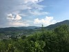
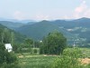
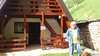

The above images may not be of the site on this page, but were taken nearby. They are loaded from Flickr so please click on them for image credits.
Click here to see more info for this site
Nearby sites
Click here to view sites on an interactive map of the areaKey: Red: member's photo, Blue: 3rd party photo, Yellow: other image, Green: no photo - please go there and take one, Grey: site destroyed
Download sites to:
KML (Google Earth)
GPX (GPS waypoints)
CSV (Garmin/Navman)
CSV (Excel)
To unlock full downloads you need to sign up as a Contributory Member. Otherwise downloads are limited to 50 sites.
Turn off the page maps and other distractions
Nearby sites listing. In the following links * = Image available
920m NE 41° Pyramid of Love* Natural Stone / Erratic / Other Natural Feature
1.6km N 353° Visoko Pyramid of Earth* Natural Stone / Erratic / Other Natural Feature
2.2km NE 43° Visoko Pyramid of the Moon* Natural Stone / Erratic / Other Natural Feature
2.2km NNW 348° Visoko Pyramid of the Sun* Natural Stone / Erratic / Other Natural Feature
4.7km NNW 337° Ravne Tunnel Megaliths* Natural Stone / Erratic / Other Natural Feature
21.2km ESE 122° Butmir* Ancient Village or Settlement
75.5km SSW 212° Zvonigrad* Hillfort
75.5km SSW 212° Zvonigrad - fortification wall* Hillfort
76.0km SSW 210° Polog.* Hillfort
88.9km SSW 207° Citluk-Greda-Illyrian observatory* Carving
97.1km SSW 192° Osanici Hillfort* Hillfort
102.4km SSW 201° Klepci tumuli 1* Round Barrow(s)
102.5km SSW 201° Klepci tumuli 2* Round Barrow(s)
107.4km SSW 205° Narona Town Wall* Hillfort
107.5km SSW 205° Narona Museum* Museum
122.0km WSW 255° Cetina Valley Ancient Village or Settlement
134.6km SSE 168° Crvena Stjena Cave or Rock Shelter
135.2km N 354° Galovo Ancient Village or Settlement
138.4km SW 220° Nakovana Cave* Cave or Rock Shelter
140.5km WSW 252° Klis Hillfort* Hillfort
144.3km WSW 252° Salona Town wall* Hillfort
144.3km WSW 252° Solin Town Gate* Ancient Village or Settlement
144.7km SSE 156° Roman bridge over Moštanica Ancient Mine, Quarry or other Industry
148.7km WSW 251° Diocletian's Palace* Ancient Palace
149.4km WSW 243° Brac Island* Ancient Village or Settlement
View more nearby sites and additional images


 We would like to know more about this location. Please feel free to add a brief description and any relevant information in your own language.
 Wir möchten mehr über diese Stätte erfahren. Bitte zögern Sie nicht, eine kurze Beschreibung und relevante Informationen in Deutsch hinzuzufügen.
 Nous aimerions en savoir encore un peu sur les lieux. S'il vous plaît n'hesitez pas à ajouter une courte description et tous les renseignements pertinents dans votre propre langue.
 Quisieramos informarnos un poco más de las lugares. No dude en añadir una breve descripción y otros datos relevantes en su propio idioma.